Maps of Parma
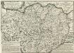
L'Etat du Duc de Parme Contenant Les Duches de Parme et Plaisance et les États Palavicin et de Landi &c.
1 : 350000 Mollova mapová sbírka Nolin, Jean-Baptiste Nolin, Jean Baptiste
DVCATO | di | PARMA | et di | PIACENZA.
[Amsterdam : Joan Blaeu]

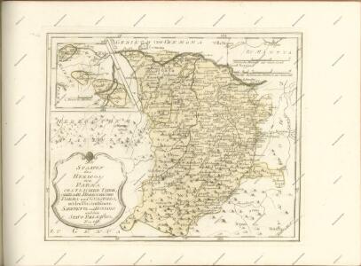
Status Parmensis
1 : 230000 Mollova mapová sbírka Homann, Johann Baptista - dědici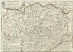
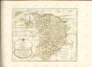
L'Etat du Duc de Parme
1 : 340000 Mollova mapová sbírka Locato, R.P. Omberto Nolin, Jean Baptiste II.
Dvcato di Modena Regio et Carpi
1 : 320000 Mollova mapová sbírka Magini, Fabio Magini, Fabio
Pianta della città di Parma = plan de la ville de Parme
Allodi inc. ; Ferd. Artaria et fils. Milan
La nobiliss.a citta di Piacenza
Piacenza (Itálie) Florimi, Matteo Matteo florimi
Parma
Parma
Parma (Itálie) Braun, Georg Hogenberg, Franz
Plan van den veldslag bij Parma tusschen de Keizerschen, en geallieerde Fransen en Savojaarden, op den 29.st Juny 1734
[S.l.] : [s.n.]
Plan de la bataille de Parme, gagnée le 29 Juin 1734 par l'armée des deux couronnes alliées sur celle de l'Empereur
[par J. B. Nolin] Te Amsterdam : bij Hendrik de Leth, kaartverkoper op de Beurssluys
Pianta icnografica della regio-ducal villa di Colorno
Colorno (Itálie) Sardi, Pietro Patrini, Giuseppe
Plan des verschanzten Lagers von Piacenza
Piacenza (Itálie)
Vorstellung uber die bey Piacenza den 16ten Juny 1746 von der kayserl. königl. hungar. Armee glückl. erfochtenen Battaille wider die feindl. combinirte Machten
1 : 113800 Piacenza-oblast (Itálie) Lidl, Johann Jakob J.J. Lidl
Gvastalla Sampt dero Gegend
1 : 220000 Mollova mapová sbírka Bodenehr, Gabriel Bodenehr, Gabriel
Ducato di Parma et di Piacenza [Karte], in: Le théâtre du monde, ou, Nouvel atlas contenant les chartes et descriptions de tous les païs de la terre, Bd. 3, S. 81.
1 Karte aus Atlas Blaeu, Willem Janszoon und Blaeu, Joan Blaeu, Willem Janszoon
Ducato di Parma et di Piacenza [Karte], in: Theatrum orbis terrarum, sive, Atlas novus, Bd. 3, S. 79.
1 Karte aus Atlas Blaeu, Joan Blaeu, Willem Janszoon
Ducato di Parma et di Piacenza [Karte], in: Novus Atlas, das ist, Weltbeschreibung, Bd. 3, S. 93.
1 Karte aus Atlas Blaeu, Joan Blaeu, Willem Janszoon
Ducato di Parma, et di Piacenza. [Karte], in: Novus atlas absolutissimus, Bd. 5, S. 136.
1 Karte aus Atlas Janssonius Offizin
Ducato Di Parma Et Di Piacenza [Karte], in: Gerardi Mercatoris et I. Hondii Newer Atlas, oder, Grosses Weltbuch, Bd. 2, S. 288.
1 Karte aus Atlas Mercator, Gerhard und Hondius, Jodocus Jansson, Jan

Ducatus Parmensis Et Placentinus
1 : 230000 Mollova mapová sbírka Seutter, Matthäus Seutter, Matthäus
Status Parmensis...

Ducato Di Modena Regio et Carpi Col Dominio della Carsagnana [Karte], in: Novus atlas absolutissimus, Bd. 5, S. 139.
1 Karte aus Atlas Janssonius Offizin
Geographische Special Carte von Italien
Mollova mapová sbírka Hemeling, Johann Carl
Dvcato di Modena regio et Carpi Col Dominio della Carsagnana
1 : 327000 titelvariant: Ducato di Modena regio et Carpi Col Dominio della Carsagnana; Annotatie: Origineel is Blad 161 in atlas factice; Annotatie geografische gegevens: Schaalstokken op de kaart: 12 Milliaria Italica communia (=6,1 cm), en: 3 Milliaria Germanica communia (=6,8 cm) Amstelodami : Apud Ioannem Ianssonium