Maps of Utrecht
14. Rijnland, uit: Geologische kaart van Nederland / door W.C.H. Staring ; bew. aan de Topographische Inrichting
1 : 200000 Winand Carel Hugo Staring 1808-1877; Topographische Inrichting, 's-Gravenhage 's-Gravenhage : Belinfante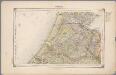
14. Rijnland, uit: Geologische kaart van Nederland / door W.C.H. Staring ; bew. aan de Topographische Inrichting
1 : 200000 Winand Carel Hugo Staring 1808-1877; Topographische Inrichting, 's-Gravenhage 's-Gravenhage : Belinfante
Rhenolandiae et Amstellandiae exactiβima Tabula. [Karte], in: Novus Atlas, das ist, Weltbeschreibung, Bd. 1, S. 394.
1 Karte aus Atlas Blaeu, Joan Blaeu, Willem Janszoon
Rhenolandiae et Amstellandiae exactißima Tabula. [Karte], in: Le théâtre du monde, ou, Nouvel atlas contenant les chartes et descriptions de tous les païs de la terre, Bd. 1, S. 425.
1 Karte aus Atlas Blaeu, Willem Janszoon und Blaeu, Joan Blaeu, Willem Janszoon
RHENOLANDIÆ | et | AMSTELLANDIÆ | exactißima Tabula
Exc. Guilj. Blaeuw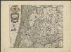
Rhenolandiae et Amstellandiae exactissima tabula
1 : 110000 exc. Guilj. Blaeuw. [S.l.] : [s.n.]
Rhenolandia, Amstelandia Et Circumiacentia aliquot Territoria, cum Aggeribus omnibus, Terminisque suis. [Karte], in: Novus atlas absolutissimus, Bd. 3, S. 179.
1 Karte aus Atlas Janssonius Offizin

Rhenolandia, Amstelandia et circumjacentia aliquot territoria, cum aggeribus omnibus, terminisq[ue] suis / accurate et distincte edita per Nicolaum Visscher
1 : 180000 Annotatie: Cum privilegio Ordinum Hollandiae et West-Frisiae; Met opdracht van Nicolaus Visscher aan Johannes Hudde; Annotatie geografische gegevens: West boven; Met 2 schaalstokken Nicolaes Jansz Visscher sr 1618-1679 [Amsterdam : Nicolaus Visscher]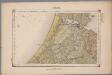
14. Rijnland, uit: Geologische kaart van Nederland : schaal van 1:200.000 / door W.C.H. Staring ; uitgevoerd door het Topographisch Bureau van Oorlog ; uitgegeven op last van Zijne Majesteit Den Koning
Annotatie: Impressum ontleend aan omslag; Kaart "Nederland de dijken weggedacht" [kaart 25] en kaart 13 (bladwijzer) vermelden het jaar 1869; Kaart 'Limburg en de Hesbaije' (bladnr. 26) vermeldt het jaar 1868; Blad 5/9 ontbreekt Topographische Inrichting, 's-Gravenhage; Topographisch Bureau Haarlem : A.C. Kruseman
La Rhinlande Amstellande et terres circõvosines
1 : 300000 auctore Balt[hasar] Flo: a Berkêrode. [Amsterdam] : [Jacob Aertsz. Colom]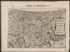
Rhinolandiæ Amstelandiæ et circumjacent. aliquot territoriû accurata descriptio
1 : 360000 Auctore Balth. Florentio a Berckenrode. Amstelodami : sumptibus Henrici Hondii.
Rijnland
1 : 200000 ['s-Gravenhage : Topographische Inrichting]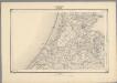
9, uit: Topografische atlas van het Koninkrijk der Nederlanden
Annotatie: Map met 19 losse krt. schaal 1:200.000 en 1 bladwijzer schaal 1:1.000.000 ['s-Gravenhage : Ministerie van Oorlog, Topografisch Bureau]
Rhenolandia, Amstelandia et circumjacentia aliquot territoria, cum aggeribus omnibus, terminisq. suis
1 : 180000 accurate et distincte edita per Nicolaum Visscher. [Amsterdam] : nunc apud Petrum Schenk Junior
't Hooge heem-raed-schap van Rhynland.
1 : 28800 [Amsterdam] : [Tirion]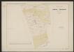
Rhinolandiae, Amstelandiae et circumiacent. aliquot territorumque, accurat desc. [Karte], in: Gerardi Mercatoris et I. Hondii Newer Atlas, oder, Grosses Weltbuch, Bd. 1, S. 451.
1 Karte aus Atlas Mercator, Gerhard und Hondius, Jodocus Jansson, Jan
Rhenolandia, Amstelandia et circumjacentia aliquot territoria, cum aggeribus omnibus terminisque suis
1 : 180000 accurate et distincte edita per Nicolaum Visscher. [Amsterdam] : [N. Visscher]
Rhinolandiae, Amstelandiae, et circumiacent. aliquot territorium, accurata desc. [Karte], in: Novus atlas absolutissimus, Bd. 3, S. 174.
1 Karte aus Atlas Janssonius Offizin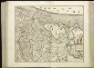
[102[104] Rhinolandiae, Amstelandiae, ..., uit: Atlas sive Descriptio terrarum orbis
Annotatie: Gedigitaliseerde versie. Amsterdam. Heiloo : Picturae (vervaardiger), 2015. tiff-bestand. Gedigitaliseerd: 07-01-2015; Origineel: Universiteitsbibliotheek Vrije Universiteit (XL.05127.-) ; Netherlands; Titelpagina ontbreekt Wit, Frederik de Amsterdam : Frederick de Wit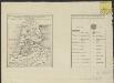
Algemeen kaartje, aantonende de uitgestrektheid en verdeling der bladen van de Kaart van een gedeelte der Departementen van Amstelland, Maasland en Utrecht
1 : 530000 onder directie en naar de geodesische waarnemingen van ... C.R.T. Krayenhoff ... te zamen gesteld en getekend door ... J.E. van Gorkum C. van Baarsel, sculp. Amsterdam : Mortier, Covens en Zoon
Rhinolandiae, Amstelandiae, et circumjacent. aliquot territoriorũ, accurata desc.
1 : 100000 Auct. Balthazaro Flor. a Berckenrode. Amstelodami : Sumptibus Henrici Hondii
Rhinolandiae, Amstelandiae, et circumiacent. aliquot territorioräu accurata desc. / auct. Balthazaro Flor. a Berckenrode
1 : 100000 Berckenrode, Balthasar Florisz. van Amstelodami : apud Frederick de Wit
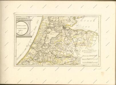
14me Utrecht, uit: [Nouvelle carte de la Hollande, d'après Kraijenhoff et les meilleures cartes connus] / [Ph. Vandermaelen]
1 : 130000 Annotatie: Ontbreekt: bl. 1-12 Vandermaelen, Philippe Marie Guillaume Bruxelles : Établissement Géographique
Kaart van het Hoogheemraadschap van Rijnland : opgedragen aan de Weledele Heeren Dijkgraaf, Hoog-Heemraden en Hoofd-Ingelanden
1 : 75000 vervaardigd naar de nieuwste Kaarten en eigen-meting en-opneming, alsook mededeeling van den Landmeter der 1e Klasse van het Kadaster W.J. van Campen, door den Eersten Opziener over den Waterstaat en Landmeter van Rijnland, J. Kros. 's Gravenhage : Lith. des Konings E. Spanier
Vernieuwde kaart van Noordholland en Westfriesland, benevens het voornaamste gedeelte van Rhynland en daar aan grenzende landen
1 : 80000 met alle naauwkeurigheid gevolgd naar de caerte van Joost Jansz Beelsnyder Ao. 1575, door Jan van Jagen, 1778 C. Bogerts sculps. Te Amsterdam : uitgeg. by Yntema en Tieboel
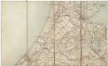
14me Utrecht, uit: Nouvelle carte de la Hollande, d'après Kraijenhoff et les meilleures cartes connues / Établissement Géographique de Bruxelles, fondé par Ph. Vander Maelen
1 : 117000 Annotatie: De bladen zijn genummerd 1-24. De bladen 2 t/m 24 hebben elk een afzonderlijke titel. Blad 5 bevat: Triangulations et positions. Blad 9 bevat: Plan d'Amsterdam; De kaartbladen 1, 5, 9 en 24 zijn niet ingekleurd; Van kaartblad 24 is een extra (ingekleurd) exempl. aanwezig; Annotatie geografische gegevens: 2 schaalstokken: 5 Echelle de 5 lieues de 20 au degré ... (= 23,2 cm) en 7380 Echelle de 5 lieues de 20 au degré ... (= 23,2 cm); Legenda; Met indexkaart: Carte d'assemblage Philippe Marie Guillaume Vander Maelen 1795-1869; Établissement Géographique de Bruxelles Bruxelles : Établissement Géographique