Maps of Bandung

Pamanoekan- en Tjiasemlanden
[S.l. : s.n.]
[Goenoeng Boekittoenggoel] / Topographisch Bureau, herzien in het jaar 1909
Topographisch Bureau Batavia Batavia : Topografisch Bureau
Subang / Direktorat Tata Guna Tanah, Departemen Dalam Negeri
Departemen Dalam Negeri Jakarta . Direktorat Tata Guna Tanah [Jakarta] : Direktorat Tata Guna Tanah, Departemen Dalam Negeri
[Segalaherang] / Survey Production Centre South East Asia ; reproduced by 110 Map Production Co[mpan]y R.E., 1945
Survey Production Centre South East Asia [S.l.] : Survey Production Centre South East Asia
Ciasem / Direktorat Tata Guna Tanah, Departemen Dalam Negeri
Departemen Dalam Negeri Jakarta . Direktorat Tata Guna Tanah [Jakarta] : Direktorat Tata Guna Tanah, Departemen Dalam Negeri
Sagalaherang / Direktorat Tata Guna Tanah, Departemen Dalam Negeri
Departemen Dalam Negeri Jakarta . Direktorat Tata Guna Tanah [Jakarta] : Direktorat Tata Guna Tanah, Departemen Dalam Negeri
[Tjimalaka] / photolithographed and reprinted from a Dutch map dated 1925 by the Army Map Service
Army Map Service U.S. Army Washington D.C. Washington D.C. : Army Map Service
[Nenggeng] / photolithographed and reprinted from a Dutch map dated 1915 by the Army Map Service
Army Map Service U.S. Army Washington D.C. Washington D.C. : Army Map Service
Cempaka / Direktorat Tata Guna Tanah, Departemen Dalam Negeri
Departemen Dalam Negeri Jakarta . Direktorat Tata Guna Tanah [Jakarta] : Direktorat Tata Guna Tanah, Departemen Dalam Negeri
Paboearan / prepared under the direction of the Chief Of Engineers U.S. Army, 1943 ; copied from a Dutch map dated 1938 [by the] Army Map Service
Army Map Service U.S. Army Washington D.C. Washington D.C. : Army Map Service
Pabuaran / Direktorat Tata Guna Tanah, Departemen Dalam Negeri
Departemen Dalam Negeri Jakarta . Direktorat Tata Guna Tanah [Jakarta] : Direktorat Tata Guna Tanah, Departemen Dalam Negeri
G[unung] Tangkuban Prahu / Direktorat Tata Guna Tanah, Departemen Dalam Negeri
Departemen Dalam Negeri Jakarta . Direktorat Tata Guna Tanah [Jakarta] : Direktorat Tata Guna Tanah, Departemen Dalam Negeri
[Bodjongkeding] : herzien in 1912-1915 / Topografische Inrichting
Topografische Inrichting Batavia Batavia : Topografische Inrichting
[Tjinangka] : herzien in 1912-1914 / Topografische Inrichting
Topografische Inrichting Batavia Batavia : Topografische Inrichting
[Maranggi] : herzien in 1912-1914 / Topografische Inrichting
Topografische Inrichting Batavia Batavia : Topografische Inrichting
[Tjibosok] : hermeten in 1909-1913 / Topografische Inrichting
Topografische Inrichting Batavia Batavia : Topografische Inrichting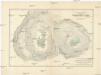
Stereophotogrammetrische Aufnahme des Kraters vom Tangkoeban Prahoe auf Java (Niederl. Jdien)
1 : 2500 Boon Luftbild-Stereographik-Konßortium
[Belendoeng] : hermeten in 1912-1914 / Topografische Inrichting
Topografische Inrichting Batavia Batavia : Topografische Inrichting
[Kalidjati] : hermeten in 1910-1912 / Topografische Inrichting
Topografische Inrichting Batavia Batavia : Topografische Inrichting
[Nenggeng] : hermeten in 1910-1912 / Topografische Inrichting
Topografische Inrichting Batavia Batavia : Topografische Inrichting
[Tjiratjas] : hermeten in 1909-1913 / Topografische Inrichting
Topografische Inrichting Batavia Batavia : Topografische Inrichting
[Tjikeusik] : opgenomen door den Topografischen Dienst in 1920-1922 / Topografische Inrichting
Topografische Inrichting Batavia Batavia : Topografische Inrichting
[Gempolsari] : hermeten in 1909-1914 / Topografische Inrichting
Topografische Inrichting Batavia Batavia : Topografische Inrichting
[Djambelar] : hermeten in 1910-1912 / Topografische Inrichting
Topografische Inrichting Batavia Batavia : Topografische Inrichting
[Manganti] : hermeten in 1912-1914 / Topografische Inrichting
Topografische Inrichting Batavia Batavia : Topografische Inrichting
[Segalaherang] : hermeten in 1910-1911 / Topografische Inrichting
Topografische Inrichting Batavia Batavia : Topografische Inrichting
[Moendjoel] : hermeten in 1912-1914 / Topografische Inrichting
Topografische Inrichting Batavia Batavia : Topografische Inrichting
[Tjidjengkol] : hermeten in 1912-1913 / Topografische Inrichting
Topografische Inrichting Batavia Batavia : Topografische Inrichting
[Tjisalak] : hermeten in 1910-1911 / Topografische Inrichting
Topografische Inrichting Batavia Batavia : Topografische Inrichting


