Maps of Zakynthos Regional Unit
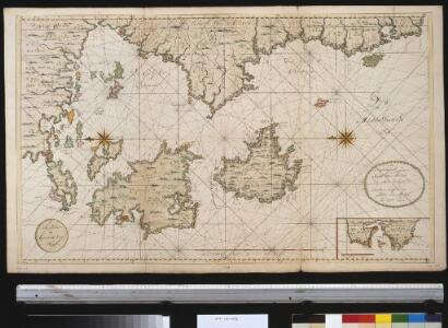
De zuijdelijkste zeekust van Morea als meede het eyland Zante en Cefalonia geleegen in de Middellandsche Zee
Greece Gerard van Keulen
Elis und Triphylia
1 : 640000 Peloponés (Řecko) Barbié du Bocage, Jean Denis
Candia cum Insulis aliquot circa Graeciam[:] [Zante] [Karte], in: Gerardi Mercatoris et I. Hondii Newer Atlas, oder, Grosses Weltbuch, Bd. 2, S. 336.
1 Karte aus Atlas Mercator, Gerhard und Hondius, Jodocus Jansson, Jan
Candia cum Insulis aliquot circa Graeciam[:] [Zante] [Karte], in: Gerardi Mercatoris Atlas, sive, Cosmographicae meditationes de fabrica mundi et fabricati figura, S. 493.
1 Karte aus Atlas Mercator, Gerhard Montanus, Petrus
Het eijland St. Maura met alle dessels havenen geleegen aen de kust van Grecia in de Middelandse Zee aen de Oost sijde vant incomen van de Golf v. Venetia
Greece Gerard van Keulen
Plan of the position of the allied squadrons and turkisch fleet in the action of the 20th Octr. 1827 at Navarino
1 : 30000 Pylos (Řecko) Officier of the Dartmouth Mollo, Tranquillo
Plan of the position of the allied squadrons and turkisch fleet in the action of the 20th Oct.r 1827 at Navarino
1 : 30000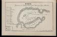
Plan sraženīja v Navarinskoj gubě, Oktjabrja 8go dnja 1827 goda
Griechenland Pylos Seeschlacht von Navarino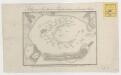
Stelling van de Geallieerde en Turksche eskaders in de haven van Navarino

Olympia
Olympia Antike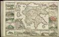
[82][82] Peloponnesus hodie Morea Regnum, ..., uit: Atlas sive Descriptio terrarum orbis
Annotatie: Gedigitaliseerde versie. Amsterdam. Heiloo : Picturae (vervaardiger), 2015. tiff-bestand. Gedigitaliseerd: 07-01-2015; Origineel: Universiteitsbibliotheek Vrije Universiteit (XL.05127.-) ; Netherlands; Titelpagina ontbreekt Wit, Frederik de Amsterdam : Frederick de Wit

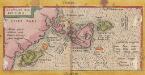
Insulae Mari Ionii. [Karte], in: Theatrum orbis terrarum, S. 416.
1 Karte aus Atlas Ortelius, Abraham

Peloponesus hodie Moreae Regnum in Omnes suas Provincias Veteres et Hodiernas accurate divisum
1 : 850000 Mollova mapová sbírka Homann, Johann Baptist Homann, Johann Baptista - dědici
Peloponesvs sive Morea
1 : 1100000 Peloponés (Řecko) Laurenberg, L.
Griechenland
1 : 2000000 Griechenland
Peloponesus hodie Morea ad normam veterum et recentiorum mappar
1 : 900000 Achaia (Řecko) Seutter, Matthäus Matth. Seutter
Regnum Moreae accuratissime divisum in provincias Saccaniam, Tzaconiam, Caliscopium et ducatum Clarensae
1 : 590000 Achaia (Řecko) Lotter, Georg F. sumptibus Tobiae Conradi Lotter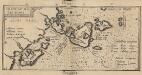
Insulae Maris Ionii. [Karte] , in: Theatrum orbis terrarum, S. 520.
1 Karte aus Atlas Ortelius, Abraham Vrients, Jan Baptista
Regnum Moreae, accuratissime divisum in provincias Saccaniam, Tzaconiam, Caliscopium et ducatum Clarensae, una cum insulis Cephalonia, Zacyntho Cythera, Aegina et Sidra
1 : 580000 sumptibus Tobiae Conradi Lotter Georg Friderich Lotter, sculpsit Aug. Vind : [T.C. Lotter]

Southern Greece, with the adjacent Islands
1 : 1100000 Arrowsmith, Aaron Jr.
Ionian Islands, Malta.
1 : 411840 Stanford, Edward
Messenia
1 : 640000 Messénie (Řecko) Barbié du Bocage, Jean Denis
La Morée Et les Isles de Zante, Cefalonie, Ste. Maure, Cerigo &c. [Karte], in: Atlas nouveau, contenant toutes les parties du monde [...], Bd. 2, S. 233.
1 Karte aus Atlas Sanson, Nicolas Jaillot, Alexis Hubert und Mortier, Pieter
Regnum Moreae accuratissime divisum in provincias Saccaniam, Tzaconiam, Caliscopium et ducatum Clarensae, una cum insulis Cephalonia, Zacyntho Cythera, AEgina et Sidra
1 : 585000 Achaia (Řecko) Lotter, Georg F. sumptibus Tobiae Conradi Lotter
[Historisch-geographischer Atlas zu den allgemeinen Geschichtswerken von C. v. Rotteck, Pölitz u. Becker] : Alt Griechenland
von Julius Loewenberg [Freiburg im Breisgau] : [Herder]