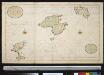
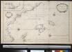
Maps of Balearic Islands
Dekust van Spanien met de eijlanden van Ivica, Majorca en Minorca
Spain Henri Michelot & Laurent Brémond Gerard van Keulen
Insulae Balearides et Pytiusae. [Karte], in: Theatrum orbis terrarum, sive, Atlas novus, Bd. 2, S. 237.
1 Karte aus Atlas Blaeu, Joan Blaeu, Willem Janszoon

Insulae Balearides et Pytiusae. [Karte], in: Novus atlas absolutissimus, Bd. 6, S. 82.
1 Karte aus Atlas Janssonius Offizin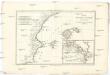
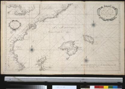
Isles Mayorque, Minorque et Yvice
1 : 7660000 Ibiza (Baleáry : ostrov) Bonne, Rigobert André
Maiorca et Minorca vulgo insvlæ Balearides et Pytivsæ
1 Karte : Kupferdruck ; 37 x 48 cm Wit apud I. Covens et C. Mortier
Insvlæ Balearides et Pytivsæ
1 Karte : Kupferdruck ; 37 x 48 cm Blaeu Joan Blaeu
Insulae Balearides et Pytiusae. [Karte], in: Le théâtre du monde, ou, Nouvel atlas contenant les chartes et descriptions de tous les païs de la terre, Bd. 2, S. 230.
1 Karte aus Atlas Blaeu, Willem Janszoon und Blaeu, Joan Blaeu, Willem Janszoon
Insulae Balearides et Pytiusae [Karte], in: Novus Atlas, das ist, Weltbeschreibung, Bd. 2, S. 237.
1 Karte aus Atlas Blaeu, Joan Blaeu, Willem Janszoon
INSVLÆ | BALEARIDES | et PYTIVSÆ.
[Amsterdam : Joan Blaeu]
[Carte d'Espagne et de Portugal en neuf feuilles, 6]
1 Blatt : 31 x 41 cm P.G. Chanlaire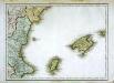
Espagne et Portugal, 6
1 Blatt : 31 x 42 cm Mentelle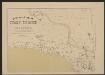
Insulae Balearides et Pytiusae. [Karte], in: Gerardi Mercatoris et I. Hondii Newer Atlas, oder, Grosses Weltbuch, Bd. 2, S. 201.
1 Karte aus Atlas Mercator, Gerhard und Hondius, Jodocus Jansson, Jan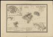
Islas Baleares con las nuevas divisiones
1 : 600000 formado por A. H. Dufour Paris : Bulla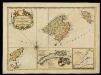
Carte des Isles de Maiorque, Minorque et Yvice / par N.B.
Bellin, Jacques Nicolas ; Dépôt de la Marine (França)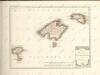

Vista de la posicion topográfica de Cataluña por su parte meridional / a S. M. Da. Isabel 2a q,D.g. dedica la presente obra su autor D. Francisco Mestres y Pujol ; ; V. Jordana scrip[si]t ; P. de la Barre fe[ci]t
1 Mapa, b/n. Mapa i projecte per al ""Resguardo de costas y fronteras"", dedicat a Isabel II. Datat al 1850 aproximadament. Mestres Pujol, Francesc ; Jordana, V. ; Barre, P. de la
Mapa general: España: Hoja 1: (Barcelona, Castellon, Gerona, Huesca, Lérida, Tarragona, Teruel) / Imp. de l'Institut Cartographique de Paris
1 : 500000 1 Mapa, col. Es presentava dins d'un sobre: Mapa turista de España en 4 colores, amb el gràfic de fulls (5 fulls). - Conté finestra de les illes Balears a 1:800 000. Datació aproximada. Blondel la Rougery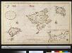
Nieuwe afteekening van de eijlanden Majorca, Ivica en Minorca als ook de haven van Porto Maon int groot geleegen in de Middelandse Zee
Spain Gerard van Keulen
Carta esferica desde cabo Oropesa a cabo de Creux
1 manuscrit. Tofiño, V.; Valdés, A.
Carte des isles de Majorque, Minorque et Yvice
1 Karte : Kupferdruck ; Bildgrösse 41 x 54 cm Bellin; Santini; Remondini chez M. Remondini
Carte des isles de Maiorque Minorque et d'Yvice
1 Karte : Kupferdruck ; Bildgrösse 47 x 55 cm Lotter s.n.
Carte welche die Inseln Maiorca, Minorca, Yvica und Formentera
1 Karte : Kupferdruck ; Bildgrösse 27 x 36 cm Bellin; Küffner s.n.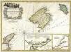
Carte des isles de Maiorque, Minorque et Yvice
1 Karte : Kupferdruck ; Bildgrösse 39 x 55 cm Bellin; Dorn les Heritiers de Homann
Carte des iles de Maiorque Minorque et d'Yvice
1 Karte : Kupferdruck ; 40 x 55 cm Bellin; Seutter; Lotter s.n.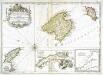
Carte des isles de Maiorque Minorque et Yvice
1 Karte : Kupferdruck ; Bildgrösse 40 x 56 cm Bellin s.n.
Carte des isles de Maiorque Minorque et d'Yvice
1 Karte : Kupferdruck ; Bildgrösse 47 x 55 cm Seutter; Lotter s.n.
Baleares seu Gymnesiae et Pityvsae insulæ, dictæ Maiorca, Minorca et Yvica
1 Karte : Kupferdruck ; 48 x 57 cm Ottens; Ottens R. et I. Ottens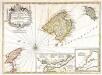
Carte des isles de Maiorque Minorque et Yvice
1 Karte : Kupferdruck ; Bildgrösse 40 x 56 cm Bellin; Condet chez I. Cóvens et C. Mortier