Maps of Zande

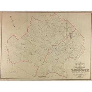
Plan parcellaire de la commune de Zevecote : avec les mutations
1 : 5000 Royal Library of Belgium Map Room Popp, Philippe Christian (1805-1879) Popp, Philippe Christian (1805-1879)
Plan parcellaire de la commune de Zande : avec les mutations
1 : 5000 Royal Library of Belgium Map Room Popp, Philippe Christian (1805-1879) Popp, Philippe Christian (1805-1879)
Plan parcellaire de la commune de St Pierre-Cappelle : avec les mutations
1 : 5000 Royal Library of Belgium Map Room Popp, Philippe Christian (1805-1879) Popp, Philippe Christian (1805-1879)
Plan parcellaire de la commune de Leffinghe : avec les mutations
1 : 5000 Royal Library of Belgium Map Room Popp, Philippe Christian (1805-1879) Popp, Philippe Christian (1805-1879)
Plan parcellaire de la commune de Ghistelles : avec les mutations
1 : 5000 Royal Library of Belgium Map Room Popp, Philippe Christian (1805-1879) Popp, Philippe Christian (1805-1879)
Plan parcellaire de la commune de Slype : avec les mutations
1 : 5000 Royal Library of Belgium Map Room Popp, Philippe Christian (1805-1879) Popp, Philippe Christian (1805-1879)
Plan parcellaire de la commune de Moere : avec les mutations
1 : 5000 Royal Library of Belgium Map Room Popp, Philippe Christian (1805-1879) Popp, Philippe Christian (1805-1879)
Plan parcellaire de la commune de Leke : avec les mutations
1 : 5000 Royal Library of Belgium Map Room Popp, Philippe Christian (1805-1879) Popp, Philippe Christian (1805-1879)
Ostende. Grid maps with 'Revised system of squaring' in top margin
1 : 40000 First World War map of Ostende. Grid maps with 'Revised system of squaring' in top margin. Improved squaring for artillery. War Office
CASTELLANIA | FURNENSIS
[Amsterdam : Joan Blaeu]
Map of water supply: Ostend
1 : 100000 Series of maps on water supplies. Ostend. War Office
Carte Particuliere des Environs de Bruges, Ostende, Damme, l'Ecluse et Autres
1 : 250000 Mollova mapová sbírka Seutter, Matthäus Lotter, Tobias Conrad Seutter, Matthäus
Flandriae Comitatus Pars Septentrionalis
1 : 133000 Mollova mapová sbírka Visscher, Nicolaes Schenk, Peter II
Brugge, Gent, Damme, Oostende, Schluys, und andere nah anliegende Staette Plaetze und Vestungen mitt deren Gegenden
1 : 115000 Belgie Bodenehr, Gabriel G. Bodenehr
Brugge, Gent, Damme, Oostende, Schluys und andere Nah an liegende Staette Plaetze und Vestungen mitt deren Gegenden
1 : 250000 Mollova mapová sbírka Bodenehr, Gabriel Bodenehr, Gabriel
Le Theatre de Bellone :
Mollova mapová sbírka Schenk, Pieter Braakman, Adriaan
Flandriae Comitatus pars occidentalis
1 : 133000 Mollova mapová sbírka Visscher, Nicolaes Schenk, Peter II
Theatre de La Guerre dans les Pais Bas et en France, Depuis La Haie jusqu'a Partis; ousont. Les Partis Meridionales d'Hollande et d'Utrecht La Zeelande La Flandre Le Brabant - Le Namur, L'Hainaut L'Artois, La Picardie, La Champagne, L'Isle de France :
1 : 250000 Mollova mapová sbírka Allard, Abraham Allart, Abraham
Franconatvs vulgo het Vrye
1 : 190000 Nizozemsko Blaeu, Joan Guiljelmus et Iohannes Blaeuw
IPRENSIS | Episcopatus
Ioh. Blaeu excud.
Flandriae tevtonicae pars orientalior
1 : 190000 Flandry Blaeu, Joan Guiljelmus et Iohannes Blaeuw exc.
FLANDRIÆ | TEVTONICÆ | PARS ORIENTALIOR
Guilielmus et Iohannes Blaeuw exc. Amsterdami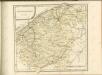

EPISCOPATVS | BRVGENSIS
[Amsterdam : Joan Blaeu]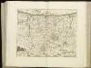
[108][111] Pars Flandriae occiden[talis] ..., uit: Atlas sive Descriptio terrarum orbis
Annotatie: Gedigitaliseerde versie. Amsterdam. Heiloo : Picturae (vervaardiger), 2015. tiff-bestand. Gedigitaliseerd: 07-01-2015; Origineel: Universiteitsbibliotheek Vrije Universiteit (XL.05127.-) ; Netherlands; Titelpagina ontbreekt Wit, Frederik de Amsterdam : Frederick de Wit
FRANCONATVS, | Vulgo | HET VRYE
Guilielmus et Iohannes Blaeuw exc. Amsterdami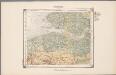
21. Walcheren, uit: Geologische kaart van Nederland / door W.C.H. Staring ; bew. aan de Topographische Inrichting
1 : 200000 Winand Carel Hugo Staring 1808-1877; Topographische Inrichting, 's-Gravenhage 's-Gravenhage : Belinfante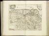
[107][110] Pars Flandriae orientalis ..., uit: Atlas sive Descriptio terrarum orbis
Annotatie: Gedigitaliseerde versie. Amsterdam. Heiloo : Picturae (vervaardiger), 2015. tiff-bestand. Gedigitaliseerd: 07-01-2015; Origineel: Universiteitsbibliotheek Vrije Universiteit (XL.05127.-) ; Netherlands; Titelpagina ontbreekt Wit, Frederik de Amsterdam : Frederick de Wit
Kriegsgeologische Uebersichtskarte für den Stellungsbau : Zusammendruck für die 4. Armee
1 : 20000 Relief shown by spot heights and hachures. War Geological overview map of the fortifications. "Stand der Erkundung: 1. September 1918." " ... am 12.9.18." "Lfd. Nr. 3297." Germany. Heer. Stoverm IV. Geologengruppe.; Germany. Heer. Vermessungs-Abteilung 24. Germany : Gruppen-Kartenstelle II, Verm. Abtlg. 24