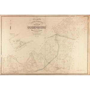
Maps of Oudenburg

Plan parcellaire de la commune de Oudenburg : avec les mutations
1 : 7500 Royal Library of Belgium Map Room Popp, Philippe Christian (1805-1879) Popp, Philippe Christian (1805-1879)
Plan parcellaire de la commune de Zandvoorde : avec les mutations
1 : 5000 Royal Library of Belgium Map Room Popp, Philippe Christian (1805-1879) Popp, Philippe Christian (1805-1879)
PLASSCHENDAELE
A. Villegas ad vivum fecit [Amsterdam : Joan Blaeu]
Plan parcellaire de la commune de Breedene : avec les mutations
1 : 5000 Royal Library of Belgium Map Room Popp, Philippe Christian (1805-1879) Popp, Philippe Christian (1805-1879)
Plan parcellaire de la commune de Ettelghem : avec les mutations
1 : 5000 Royal Library of Belgium Map Room Popp, Philippe Christian (1805-1879) Popp, Philippe Christian (1805-1879)
Ostende. Grid maps with 'Revised system of squaring' in top margin
1 : 40000 First World War map of Ostende. Grid maps with 'Revised system of squaring' in top margin. Improved squaring for artillery. War Office
Plan parcellaire de la commune de Clemskerke : avec les mutations
1 : 7500 Royal Library of Belgium Map Room Popp, Philippe Christian (1805-1879) Popp, Philippe Christian (1805-1879)
Plan parcellaire de la commune de Steene : avec les mutations
1 : 5000 Royal Library of Belgium Map Room Popp, Philippe Christian (1805-1879) Popp, Philippe Christian (1805-1879)
Plan parcellaire de la commune de Snaeskerke : avec les mutations
1 : 5000 Royal Library of Belgium Map Room Popp, Philippe Christian (1805-1879) Popp, Philippe Christian (1805-1879)
Plan parcellaire de la commune de Ghistelles : avec les mutations
1 : 5000 Royal Library of Belgium Map Room Popp, Philippe Christian (1805-1879) Popp, Philippe Christian (1805-1879)
Plan parcellaire de la commune de Westkerke : avec les mutations
1 : 5000 Royal Library of Belgium Map Room Popp, Philippe Christian (1805-1879) Popp, Philippe Christian (1805-1879)
Plan parcellaire de la commune de Roxem : avec les mutations
1 : 5000 Royal Library of Belgium Map Room Popp, Philippe Christian (1805-1879) Popp, Philippe Christian (1805-1879)
OSTENDA OBSESSA ET CAPTA | Ab Alberto et Isabella d.g. Archiducib. Austriæ, | Ducib. Burgundiæ, Brabantiæ, etc. Com. Flandriæ, etc.
Inset: OSTENDA ut jam conspicitur A 1641. - 12.5 x 14 cm [Amsterdam : Joan Blaeu]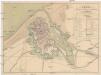
Plan du fort, de la ville et des environs d'Ostende
1 : 7400 Ostende (Belgie) Bulcke, François Elleboudt, J.
La Flandre
Mollova mapová sbírka Aa, Pieter van der Aa, Janson Vander
Carte Particuliere des environs de Bruges, Ostende, Damme, l'Ecluse et autres
1 : 116600 Mollova mapová sbírka Fricx, Eugène Henry Covens, Johannes I
Carte particuliere des Environs de Bruges, Ostende, Damme, l'Ecluse et Autres
1 : 116600 Mollova mapová sbírka Fricx, Eugène Henry Harrewyn, Jacques Fricx, Eugené Henry
Carte Particuliere des Environs de Bruges, Ostende, Damme, l'Ecluse et Autres
1 : 250000 Mollova mapová sbírka Seutter, Matthäus Lotter, Tobias Conrad Seutter, Matthäus
Carte particuliere des environs de Bruges, Ostende, Damme, l'Ecluse et autres
1 : 110000 Belgie Fricx, Eugene Henry Harrewyn, Jacques chez Eugene Henry Fricx
Flandriae Comitatus Pars Septentrionalis
1 : 133000 Mollova mapová sbírka Visscher, Nicolaes Schenk, Peter II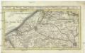
Brugge, Gent, Damme, Oostende, Schluys, und andere nah anliegende Staette Plaetze und Vestungen mitt deren Gegenden
1 : 115000 Belgie Bodenehr, Gabriel G. Bodenehr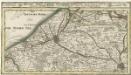
Brugge, Gent, Damme, Oostende, Schluys und andere Nah an liegende Staette Plaetze und Vestungen mitt deren Gegenden
1 : 250000 Mollova mapová sbírka Bodenehr, Gabriel Bodenehr, Gabriel
Le Theatre de Bellone :
Mollova mapová sbírka Schenk, Pieter Braakman, Adriaan
Theatre de La Guerre dans les Pais Bas et en France, Depuis La Haie jusqu'a Partis; ousont. Les Partis Meridionales d'Hollande et d'Utrecht La Zeelande La Flandre Le Brabant - Le Namur, L'Hainaut L'Artois, La Picardie, La Champagne, L'Isle de France :
1 : 250000 Mollova mapová sbírka Allard, Abraham Allart, Abraham
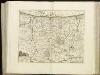
Franconatvs vulgo het Vrye
1 : 190000 Nizozemsko Blaeu, Joan Guiljelmus et Iohannes Blaeuw
Flandriae tevtonicae pars orientalior
1 : 190000 Flandry Blaeu, Joan Guiljelmus et Iohannes Blaeuw exc.
FLANDRIÆ | TEVTONICÆ | PARS ORIENTALIOR
Guilielmus et Iohannes Blaeuw exc. Amsterdami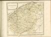

EPISCOPATVS | BRVGENSIS
[Amsterdam : Joan Blaeu]