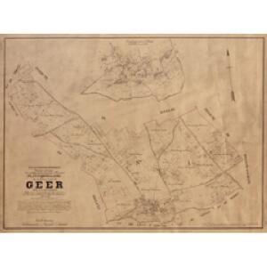
Maps of Geer

Plan parcellaire de la commune de Geer : avec les mutations
1 : 5000 Royal Library of Belgium Map Room Popp, Philippe Christian (1805-1879) Popp, Philippe Christian (1805-1879)
Plan parcellaire de la commune de Boelhe : avec les mutations
1 : 5000 Royal Library of Belgium Map Room Popp, Philippe Christian (1805-1879) Popp, Philippe Christian (1805-1879)
Plan parcellaire de la commune de Lens-St-Remy : avec les mutations
1 : 5000 Royal Library of Belgium Map Room Popp, Philippe Christian (1805-1879) Popp, Philippe Christian (1805-1879)
Plan parcellaire de la commune de Trognée : avec les mutations
1 : 5000 Royal Library of Belgium Map Room Popp, Philippe Christian (1805-1879) Popp, Philippe Christian (1805-1879)
Plan parcellaire de la commune de Hollogne-sur-Geer : avec les mutations
1 : 5000 Royal Library of Belgium Map Room Popp, Philippe Christian (1805-1879) Popp, Philippe Christian (1805-1879)
Plan parcellaire de la commune de Lens-Saint-Servais : avec les mutations
1 : 5000 Royal Library of Belgium Map Room Popp, Philippe Christian (1805-1879) Popp, Philippe Christian (1805-1879)
Plan parcellaire de la commune de Darion : avec les mutations
1 : 2500 Royal Library of Belgium Map Room Popp, Philippe Christian (1805-1879) Popp, Philippe Christian (1805-1879)
Plan parcellaire de la commune de Cras-Avernas : avec les mutations
1 : 5000 Royal Library of Belgium Map Room Popp, Philippe Christian (1805-1879) Popp, Philippe Christian (1805-1879)
Plan parcellaire de la commune de Ligney : avec les mutations
1 : 2500 Royal Library of Belgium Map Room Popp, Philippe Christian (1805-1879) Popp, Philippe Christian (1805-1879)
Comté de Namur
1 : 115000 A Amsterdam : chez Cóvens et Mortier
Prima Pars Brabantiae cuius caput Lovanium
1 : 135000 auctore Michaele Florentio a Langren Guiljelmus Blaeu excudit [Amsterdam] : [Blaeu]
PRIMA PARS | BRABANTIÆ | cuius caput | LOVANIVM
Auctore | Michaele Florentio a Langren | Hispan. regis mathematico. Guiljelmus Blaeu excudit

Prima Pars Brabantiae cuius caput Lovanium [Karte], in: Novus Atlas, das ist, Weltbeschreibung, Bd. 1, S. 313.
1 Karte aus Atlas Blaeu, Joan Blaeu, Willem Janszoon
Prima Pars Brabantiae cuius caput Lovanium [Karte], in: Le théâtre du monde, ou, Nouvel atlas contenant les chartes et descriptions de tous les païs de la terre, Bd. 1, S. 343.
1 Karte aus Atlas Blaeu, Willem Janszoon und Blaeu, Joan Blaeu, Willem Janszoon
Prima Pars Brabantiae cuius caput Lovanium [Karte], in: Novus atlas absolutissimus, Bd. 3, S. 42.
1 Karte aus Atlas Janssonius Offizin
Lovaniensis Tetrarchia
1 : 133000 Mollova mapová sbírka Visscher, Nicolaes Jansz. Schenk, Peter II
Prima Pars Brabantiae cuius caput Lovanium [Karte], in: Theatrum orbis terrarum, sive, Atlas novus, Bd. 1, S. 335.
1 Karte aus Atlas Blaeu, Joan Blaeu, Willem Janszoon
Lovaniensis tetrarchia una cum Arscotano ducatu in eiusdem ditiones subiacentes accuratissime divisa
1 : 176000 Aarschot (Belgie) Visscher, Nicolaes Jansz. Schenk, Pieter apud Petrum Schenk iunior
XIV ; 3.L., uit: Carte chorographique des Pays-Bas Autrichiens / ... par le Comte de Ferraris ; gravée par L.A. Dupuis
1 : 86400 Annotatie: Bladen linksboven genummerd met Romeinse cijfers, rechtsboven met een cijfer en een letter; Met opdracht aan keizer Joseph II (bl.XVI); Met plattegrond van Brussel (bl. XXI), overzichtskaart (bl. XXII) en bladwijzer (bl. XXIII); Annotatie geografische gegevens: Schaalstokken: Echelle de Toises ou de Lieues communes de France; Echelle de Verges ou de Lieues de Brabant; Echelle de Milles d'Allemagne (bl. XVII); Echelle de Mètres; In de hoeken lengte- en breedtematen T.M.e en T.P.e Joseph-Jean François Ferraris Comte de 1726-1814; L.A. Dupuis [S.l. : s.n.]
27. Limburg, uit: Geologische kaart van Nederland / door W.C.H. Staring ; bew. aan de Topographische Inrichting
1 : 200000 Winand Carel Hugo Staring 1808-1877; Topographische Inrichting, 's-Gravenhage 's-Gravenhage : Belinfante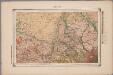
27. Limburg, uit: Geologische kaart van Nederland : schaal van 1:200.000 / door W.C.H. Staring ; uitgevoerd door het Topographisch Bureau van Oorlog ; uitgegeven op last van Zijne Majesteit Den Koning
Annotatie: Impressum ontleend aan omslag; Kaart "Nederland de dijken weggedacht" [kaart 25] en kaart 13 (bladwijzer) vermelden het jaar 1869; Kaart 'Limburg en de Hesbaije' (bladnr. 26) vermeldt het jaar 1868; Blad 5/9 ontbreekt Topographische Inrichting, 's-Gravenhage; Topographisch Bureau Haarlem : A.C. Kruseman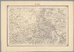
19, uit: Topografische atlas van het Koninkrijk der Nederlanden
Annotatie: Map met 19 losse krt. schaal 1:200.000 en 1 bladwijzer schaal 1:1.000.000 ['s-Gravenhage : Ministerie van Oorlog, Topografisch Bureau]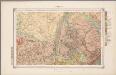
27. Limburg, uit: Geologische kaart van Nederland / door W.C.H. Staring ; bew. aan de Topographische Inrichting
1 : 200000 Winand Carel Hugo Staring 1808-1877; Topographische Inrichting, 's-Gravenhage 's-Gravenhage : Belinfante
[Kaart], uit: Carte routière des environs de Namur
1 : 160000 Bruxelles : De Boeck
Carte No 67. Limbourg

Tetrarchia Lovaniensis una cum Arschotano Ducatu
1 : 135000 quam emendatam [...] dedicat consecratque M. van Medtman Lovanii A Amsterdam : chez R. & I. Ottens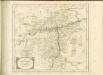

Leodiensis Episcopatus
1 : 130000 Mollova mapová sbírka Visscher, Nicolaes Schenk, Peter I