Maps of Sandefjord

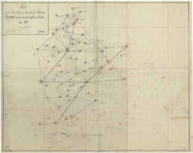
Trigonometrisk grunnlag, Squelet-Cart 34: En Deel af Laurvigs Grevskab trigonometrisk bestemte Punkter
H. Gløersen | J. J. Broch
Trigonometrisk grunnlag, Squelet-Cart 30: En Deel af Laurvigs Grevskab
H. Gløersen
9D 1 vest
1 : 50000 Nicolay Caspary Ræder
Kartblad 17: Wey-Cart af det Westre Laurwigske Compagnie District
von Petersen
Kartblad 15: Militair Cart over det Nordre Lauerwigske Compagnie District
Blix
1713-2 Porsgrunn
1 : 50000 Statens kartverk
1813-3 Sandefjord
1 : 50000 Statens kartverk
1813-3 Sandefjord
1 : 50000 Norges Geografiske Oppmåling
1813-3 Sandefjord
1 : 50000 Statens kartverk
1813-3 Sandefjord
1 : 50000 Norges Geografiske Oppmåling
1813-3 Sandefjord
1 : 50000 Statens kartverk
1813-3 Sandefjord
1 : 50000 Norges Geografiske Oppmåling
1713-2 Porsgrunn
1 : 50000 Statens kartverk
1713-2 Porsgrunn
1 : 50000 Statens kartverk
1713-2 Porsgrunn
1 : 50000 Statens kartverk
1713-2 Skien
1 : 50000 Norges Geografiske Oppmåling
Museumskart 217-58: Specialkart over Kristianiafjorden fra Tønsberg Tønde til Jomfruland
1 : 50000 A. Dellinger Den Geografiske Opmaaling
Museumskart 37: Kaart over Grevskaberne Jarlsberg og Laurvigen
1 : 50000
9C 3 9C 7 9C 11 14A 3
1 : 100000 Ramm
Museumskart 39: Situations Kaart over Fiordene fra Langesund til Scheen
1 : 50000
Kartblad 16: Millitair Cort over det Østere Lauerwigske Compagnie District
Blekkesrud | Tharum
1713-2 Porsgrunn
1 : 50000 Norges Geografiske Oppmåling
Kartblad 14: Millitairisk Vey-Cart over det Søndre Jarlsbergske Compagnie
Fougner | Hans Rad Ager
9D 1 sà ̧
1 : 25000 Marius Widerà ̧e
9B 10 nv
1 : 25000 Kristen Gran Gleditsch
9D 1
1 : 20000
Museumskart 35: Kaart over Udseilingen fra Tønsberg til Bulleren
1 : 20000
9D 5
1 : 50000 Marius Widerà ̧e
9B 9
1 : 20000 JÃ ̧rgen Scielderup Grimseth