Maps of Kirkenes

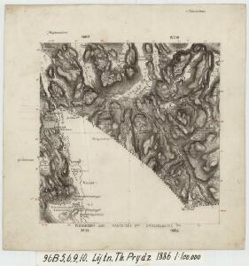
96B 5; 96B 6; 96B 9; 96B10
1 : 100000 Thorvald Prydz
2434-2 Kirkenes
1 : 50000 Norges Geografiske Oppmåling
2434-2 Kirkenes
1 : 50000 Statens kartverk
2434-2 Kirkenes
1 : 50000 Norges Geografiske Oppmåling
2434-2 Kirkenes
1 : 50000 Statens kartverk
2434-2 Kirkenes
1 : 50000 Statens kartverk
2434-2 Kirkenes
1 : 50000 Norges Geografiske Oppmåling
Ø6, Ø7 og Ø8. Kirkenesområdet Karpelvdalen
1 : 25000
Æ5 sørøstre del
1 : 25000 Andreas Theodor Walle | O. Ruud
Ø6 nordre del og Ø9 nordre del ?
1 : 25000 Thoralf Martinsen | Andreas Theodor Walle
Finmarkens amt 62: Kart over Den norske kyst fra Tromsà ̧ til Grændsen mod Russland
1 : 350000 G. L. Fehr, Vibe
Finmarkens amt 48-K: Grændserà ̧skarter, optagne under Grændserydningerne 1896 og 1897
1 : 8400 Gustaf Peter GrÃ1⁄4ner
Finmarkens amt 48-M: Grændserà ̧skarter, optagne under Grændserydningerne 1896 og 1897
1 : 8400 M. A. Ween
Finmarkens amt 48-J1: Grændserà ̧skarter, optagne under Grændserydningerne 1896 og 1897
1 : 8400 M. A. Ween
Finmarkens amt 48-L: Grændserà ̧skarter, optagne under Grændserydningerne 1896 og 1897
1 : 8400 M. A. Ween
96A 4; 96B 1
1 : 100000 Johan Christopher Ræder
Æ5 sørøstre del og Æ6 nord østre del
1 : 25000 Andreas Theodor Walle | R. Østerholt
Æ6 nordøstre del
1 : 25000 Andreas Theodor Walle
96B 7; 96B 8
1 : 100000 Thorvald Prydz
Ø6 Karpelven
1 : 100000 Arnt Magnus Andreassen Øgaard | Ole Engh
Ø5 Jarfjorden
1 : 100000 Johan Nordhagen | Arnt Magnus Andreassen Øgaard
Ø6 Karpelven
1 : 100000 Arnt Magnus Andreassen Øgaard | Ole Engh
Ø6 Karpelven
1 : 100000
Ø6 Karpelven
1 : 100000 Arnt Magnus Andreassen Øgaard | Ole Engh
Æ6 Svanvik
1 : 100000
Æ5 Neiden
1 : 100000 Johan Gulbrandsen Natrud
Æ5 Neiden
1 : 100000 Johan Gulbrandsen Natrud | C. Pedersen
96D 1; 96D 2; 96D 5
1 : 100000 Daniel Tønnesen
Finmarkens amt nr 5: Alte Botne udi Finmarken
1 : 70000 Mattis Ibsen