Maps of Vevelstad

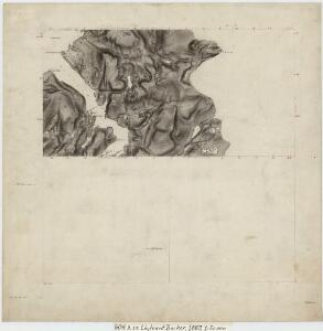
60A 9; 60A 10
1 : 50000 Thomas Georg Backer
Geologisk kart 124: Vistenvassdraget - Kvartærgeologi og geomorfologi
1 : 50000 J. L. Sollid | L. M. Sollid Geografisk institutt, Universitetet i Oslo
1826-2 Eiterå
1 : 50000 Norges Geografiske Oppmåling
1826-2 Eiterådalen
1 : 50000 Statens kartverk
1826-2 Eiterådalen
1 : 50000 Norges Geografiske Oppmåling
1826-2 Eiterådalen
1 : 50000 Statens kartverk
60A 1; 60A 5
1 : 50000 Hans Gjestvang
1826-2 Eiterådalen
1 : 50000 Statens kartverk
1826-3 Vevelstad
1 : 50000 Statens kartverk
60A 2; 60A 6
1 : 50000 Carl Aksel Sigurd Sissener
1826-3 Vevelstad
1 : 50000 Norges Geografiske Oppmåling
60A 10; 60C 1 (halv); 60C 2
1 : 50000 Thomas Georg Backer
I18 Velfjord
1 : 100000
1826-3 Vevelstad
1 : 50000 Statens kartverk
1826-3 Vevelstad
1 : 50000 Statens kartverk
I18 Velfjorden
1 : 100000 Arnt Magnus Andreassen Øgaard
I18 Velfjord
1 : 100000 Arnt Magnus Andreassen Øgaard | H. C. Wanggård
59B 4; 59B 8
1 : 50000 Hans Gjestvang
59B 12
1 : 50000 Hans Gjestvang
I18 Velfjorden
1 : 100000 H. C. Wanggård | Arnt Magnus Andreassen Øgaard
I17 Mosjøen
1 : 100000 Torgrim Lundtvedt | C. Pedersen
Norge 55-12: Accurat landcaart over Norges Rige anden Part
1 : 3000000 G. Bordin
I18 Velfjord
1 : 100000 Arnt Magnus Andreassen Øgaard | H. C. Wanggård
I17 Mosjøen
1 : 100000 C. Pedersen | Torgrim Lundtvedt
I17 Mosjøen
1 : 100000
I18 Velfjord
1 : 100000
I17 Mosjøen
1 : 100000
I17 Mosjøen
1 : 100000 C. Pedersen | Torgrim Lundtvedt
I17 Mosjøen
1 : 100000