Maps of Gjøvik

25B 8
1 : 50000 Oluf Holm
25B 8
1 : 50000 Oluf Holm
Kartblad 176-b: Det Nordre Totenske Compagnie District
E. Fougner
25B 4; 25B 8
1 : 50000 Niels Finckenhagen
25B 8; 25B 12
1 : 50000 Schilling
Fra Helgerud til Bråstad
J. H. Reichborn
Fra Slagsvoll til Stensli
J. H. Reichborn
Kartblad 3: Kart over Veien fra Eidsvold til Gausdal og til Skydsstationen Holmen i Øyer
J. H. Reichborn
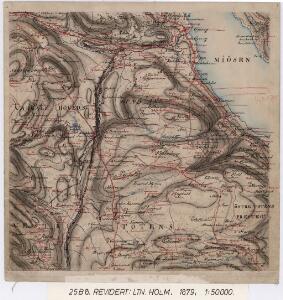
25B 8
1 : 20000 Collin
1816-1 Gjövik
1 : 50000 Norges Geografiske Oppmåling
1816-1 Gjøvik
1 : 50000 Statens kartverk
25B Gjøvik
1 : 100000 Holm | Ole Engh Dahls oppmåling
25B Gjøvik
1 : 100000
Spesielle kart 34: Christiania - Gjøvik-Banen
1 : 100000
Geologiske kart 25: Den geologiske Undersøgelse, Gjøvik
1 : 100000 O. Hagen | P. Krohn | Holm | Theodor Kjerulf Norges geologiske undersøkelse
Spesielle kart 33: Christiania - Gjøvik-Banen
1 : 100000
Kartblad 176-a: Det Nordre Totenske Compagnie District
E. Fougner
25B Gjøvik
1 : 100000 Holm | Ole Engh
25B Gjøvik
1 : 100000 Holm | Ole Engh
1816-1 Gjövik
1 : 50000 Norges Geografiske Oppmåling
Geologisk kart 8b: Jordbundskart over en del af Mjøsens Omegn
1 : 100000 Theodor Kjerulf | Irgens
Trigonometrisk grunnlag, vedlegg 51
1 : 50000
1816-2 Eina
1 : 50000 Statens kartverk
1816-2 Eina
1 : 50000 Norges Geografiske Oppmåling
1916-4 Hamar
1 : 50000 Statens kartverk
Kartblad 50: Militairisk Wej-Cart over det Westre Hedemarkske Compagnie District
De Place
1816-2 Eina
1 : 50000 Statens kartverk
1816-2 Eina
1 : 50000 Statens kartverk
1816-2 Eina
1 : 50000 Norges Geografiske Oppmåling