Maps of Bærum

15C 3 nø
1 : 25000 Johannes Solem
Mil nr 57
1 : 10000 Scheel
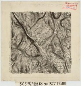
15C 3
1 : 20000 Ramm
15C 3 sør
1 : 10000 Qvist
15C 3 nord
1 : 10000 Qvist
15C 3 sø
1 : 25000 Håkon Bernhard Hansen
15C 7 sø
1 : 25000 Johannes Solem
15C 3 nv
1 : 25000 David Ebbesen | Johannes Solem
Jegerkorps nr 9: Kart over den nordlige del av Hemnæs, Baastad, Enebak, Høland, vestre del
1 : 13000 Kiølstad
15C 2; 15C 3 (geometrisk hovednet)
1 : 50000
1914-1 Fet
1 : 50000 Statens kartverk
15C 4; 15C 8 (geometrisk hovednet)
1 : 50000
15A 11; 15C 3
1 : 25000 Toralf Øyen
Nr. 14; felt 29-30
1 : 25000 Th. Ween
1914-1 Öyeren
1 : 50000 Norges Geografiske Oppmåling
1914-1 Fet
1 : 50000 Norges Geografiske Oppmåling
1914-1 Fet
1 : 50000 Statens kartverk
1914-1 Fet
1 : 50000 Statens kartverk
1914-1 Fet
1 : 50000 Norges Geografiske Oppmåling
Jegerkorps nr 18: Kart over Baastad, Hemnes, Trøgstad, Askim og en del av Eidsberg og Røddenæs, del B
1 : 13000 Kinestad | von Staffeldt | von Stabell
Jegerkorps nr 9: Kart over den nordlige del av Hemnæs, Baastad, Enebak, Høland, østre del
1 : 13000 Kiølstad
Jegerkorps nr 10B: Kart over Hovi, Tomter, Ski og anneks til Enebak og Høland, øst
1 : 13000
Nr. 14; felt 32
1 : 25000 Graff - Wang Generalstabens topografiske avdeling
Mil nr 58
1 : 10000 Johan Henrich Ramm
Nr. 14; felt 31
1 : 25000 H. K. Hertzberg Generalstabens topografiske avdeling
Nr. 14; felt 27 ø
1 : 25000 Schiøtz Generalstabens topografiske avdeling
15C 4 nv
1 : 25000 Johannes Solem
15A 11
1 : 25000 Georg Otto Lorange
15C 4 sør
1 : 10000 Qvist