Maps of Flekkefjord

Museumskart 68: Kart over den Norske kyst fra Christiansand til Ekersund
1 : 200000 H. Wille | Schie
Museumskart 217-2 Kart over Den Norske Kyst fra Christiansand til Ekersund
1 : 50000 H. Wille | Schie Opmaalings Directionen
Geologiske kart 121-F: Kart med magnetisk totalfelt. Mandal
1 : 250000 Norges geologiske undersøkelse
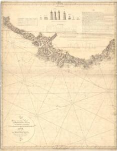
The coast of NORWAY from Bergen to the High Land of Horrel
from The sea-atlas : containing an hydrographical description of most of the sea-coasts of the known parts of the world.
Museumskart 217-27: Kart over Den Norske Kyst fra Lindesnæs til Ekersund
1 : 50000 H. Wille | Schie Opmaalings Directionen
Museumskart 217-25: Kart over Den Norske Kyst fra Christiansand til Lindesnæs
1 : 50000 H. Wille | Schie Opmaalings Directionen
Museumskart 66: Kart over den Norske kyst fra Lindesnæs til Ekersund
1 : 100000 H. Wille | Schie
Trigonometrisk grunnlag, Squelet-Cart 47: Kart for 1851
C. S. Grimsgaard
Trigonometrisk grunnlag, Squelet-Cart 18-2: Kysten fra Tromøy til Christiansand
Niels Andreas Wibe | B. Aubert
Portefølje nr 1
1 : 100000 F. Næser | H. Gill
Portefølje nr 1
1 : 100000 F. Næser | H. Gill
Portefølje nr 2
1 : 100000 H. Gill
Portefølje nr 2
1 : 100000 H. Gill
Spesielle kart 36: Egersund - Flekkefjordbanen
1 : 200000
1D Mandal
1 : 100000 Oluf Lier | Ole Engh
Museumskart 65: Kart over Den Norske Kyst fra Christiansand til Lindesnæs
1 : 150000 Schie
4A Flekkefjord
1 : 100000 Torgrim Lundtvedt | C. Pedersen
Geologisk kart 3-1b: Snitt over det Søndenfjeldske Norge
1 : 200000 P. Waage | H. Mohn | Tellef Dahll | A. S. Bachke
Kartblad 143-2: Geographiske Wej-Cart over det 2det Mandahlske Compagnie District; versjon 2

Kartblad 143- Geographiske Wej-Cart over det 2det Mandahlske Compagnie District; versjon 1

4A Flekkefjord
1 : 100000
4A Flekkefjord
1 : 100000 C. Pedersen | Torgrim Lundtvedt
4A Flekkefjord
1 : 100000 Torgrim Lundtvedt | C. Pedersen
4A Flekkefjord
1 : 100000
1C Lodshavn
1 : 100000 Ole Engh | Ole Tostad
1C Lodshavn
1 : 100000
1D Mandal
1 : 100000 H. Wangård | Oluf Lier
1D Mandal
1 : 100000 H. Wangård | Oluf Lier
1D Mandal
1 : 100000