Maps of Lierne

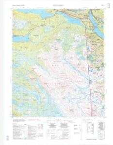
1923-1 Murusjöen
1 : 50000 Statens kartverk
1923-1 Murusjöen
1 : 50000 Norges Geografiske Oppmåling
1923-1 Murusjöen
1 : 50000 Norges Geografiske Oppmåling
1923-1 Murusjøen
1 : 50000 Statens kartverk
54B 6; 54B 7; 54B 8; 54B 10; 54B 11; 54B 12
1 : 50000 Thorvald Prydz
54B 3; 54B 4
1 : 50000 Thorvald Prydz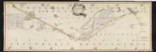
NRA GA 13
Krogh | Thodal | Mackuer | Marelius | Holm | Wetterstedt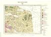
Geologisk kart 86: Nordli
1 : 100000 Steinar Foslie Norges geologiske undersøkelse
54B 1; 54B 2; 54B 5
1 : 50000 Georg Peter Leganger Mamen
1924-2 Limingen
1 : 50000 Norges Geografiske Oppmåling
1924-2 Limingen
1 : 50000 Norges Geografiske Oppmåling
1924-2 Limingen
1 : 50000 Statens kartverk
1923-2 Sørli
1 : 50000 Norges Geografiske Oppmåling
1923-2 Sørli
1 : 50000 Statens kartverk
1923-2 Sørli
1 : 50000 Statens kartverk
1923-2 Sørli
1 : 50000 Statens kartverk
Statistikk 43-18- Bosettingskart over Grogn. Blad 18
1 : 250000 Statistisk Sentralbyrå
Statistikk 43-18-2: Bosettingskart over Grong. Blad 18
1 : 250000 Statistisk Sentralbyrå
Liene
1 : 250000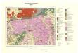
Geologisk kart 93: Sanddøla
1 : 100000 Steinar Foslie Norges geologiske undersøkelse
1923-2 Rengen
1 : 50000 Norges Geografiske Oppmåling
1923-4 Nordli
1 : 50000 Statens kartverk
51D 2; 51D 3; 51D 6; 51D 7; 51D 10; 51D 11; 51D 12
1 : 50000 David Vogt
54B 9
1 : 50000 Vilhelm Herman Ludvig von Munthe af Morgenstierne
51D Sørli
1 : 100000 Johan Nordhagen | Prydz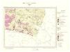
Geologisk kart 96: Sørli
1 : 100000 Steinar Foslie Norges geologiske undersøkelse
51D Sørli
1 : 100000 Johan Nordhagen | Prydz
51D Sørli
1 : 100000 Ole Engh | Prydz
51D Sørli
1 : 100000 Ole Engh | Prydz