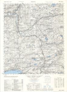
Maps of Snåsa

1823-4 Grong
1 : 50000 Norges Geografiske Oppmåling
1823-4 Grong
1 : 50000 Norges Geografiske Oppmåling
1823-4 Grong
1 : 50000 Statens kartverk
1823-4 Grong
1 : 50000 Norges Geografiske Oppmåling
1823-4 Grong
1 : 50000 Statens kartverk
1823-4 Grong
1 : 50000 Statens kartverk
54A 5; 54A 9
1 : 50000 Hans Gjestvang
53B 3; 53B 4; 53B 8
1 : 50000 Eiler Christian Holtermann
54A 1
1 : 50000 Thomas Georg Backer
53B 7; 53B 11; 53B 12
1 : 50000 Eiler Christian Holtermann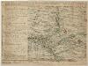
Kartblad 90-2: Cituations Carte over det Overhaldske Præstegield og Major F. H. Sommerschields Compagnie; versjon 2
Henrich Christopher Sommerschield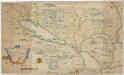
Kartblad 168: Carta over Schieløber-Compagniet og Eendeel af det Første Tronhiemsche Regiement
Christian Wilhelm Klüwer
53B Overhalla
1 : 100000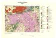
Geologisk kart 93: Sanddøla
1 : 100000 Steinar Foslie Norges geologiske undersøkelse
Kartblad 89: Overhaldske Compagnie
P. Q. Borg
53B Overhalla
1 : 100000
53B Overhallen
1 : 100000 Torgrim Lundtvedt | Einar Sigurd Ween
53B Overhalla
1 : 100000 Einar Sigurd Ween | Torgrim Lundtvedt
53B Overhalla
1 : 100000 Torgrim Lundtvedt | Einar Sigurd Ween
53B Overhallen
1 : 100000 Torgrim Lundtvedt | H. Hagen
53B Overhalla
1 : 100000
53B Overhalden
1 : 100000 Torgrim Lundtvedt | H. Hagen
54A Sanddøla
1 : 100000
54A Sanddøla
1 : 100000 Thorvald Prydz | C. Pedersen
54A Sanddøla
1 : 100000
54A Sanddøla
1 : 100000 Nicolai Franck | Thorvald Prydz
54A Sanddøla
1 : 100000 Thorvald Prydz | C. Pedersen
Kartblad 86: Wey-Cart over det Stodske Compagnie District
von Rosenvinge
1824-3 Harran
1 : 50000 Norges Geografiske Oppmåling