Maps of Luster

D30-10; D30-11; D30-12
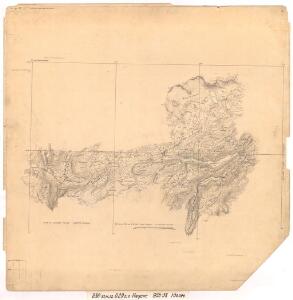
1 : 50000 Gunvald Hagene
1518-3 Sygnefjell
1 : 50000 Norges Geografiske Oppmåling
D30-12
1 : 50000 Gunvald Hagene
1518-3 Sygnefjell
1 : 50000 Statens kartverk
1518-3 Sygnefjell
1 : 50000 Norges Geografiske Oppmåling
1518-3 Sognefjellet
1 : 50000 Statens kartverk
1518-3 Sognefjellet
1 : 50000 Statens kartverk
D29-4; D29-5
1 : 50000 Gunvald Hagene
Kroki i 100000 over trakten Skarvedalseggen - Heggebotthovd - Skarstind
1 : 100000 Finn Qvale
D29-5; D29-6; E29-1
1 : 50000 Gunvald Hagene
Kart over Gaardene Lien
1 : 5000 K. M. Norum
D30 aust Sygnefjell
1 : 100000
D30-10D; 30-12; D30-11
1 : 50000 Gunvald Hagene
D30 aust Sygnefjell
1 : 100000
30C 5; 30C 6; 30C 7; 30C 9; 30C 10; 30C 11; 29D 12
1 : 100000 Henrik Lund
D29 aust Skjåk
1 : 100000
D29 aust Skjåk
1 : 100000
D29 aust Skjåk
1 : 100000
C29 aust Skjåk
1 : 50000
D30 aust Sygnefjell
1 : 100000
D30 aust Sygnefjell
1 : 100000
1518-4 Pollfoss
1 : 50000 Statens kartverk
1518-2 Galdhöpiggen
1 : 50000 Statens kartverk
1518-2 Galdhøpiggen
1 : 50000 Statens kartverk
1518-2 Galdhöpiggen
1 : 50000 Norges Geografiske Oppmåling
1518-2 Visdalen
1 : 50000 Norges Geografiske Oppmåling
30D 1; 30D 2; 30D 3; 30D 5; 30D 6; 30D 7; 30D 9; 30D 10; 30D 11; 30C 4; 30C 7; 30C 8; 30C 11; 30C 12; 30B 10; 36A 3; 36A 4; 36B 1; 36B 2
1 : 100000 Harald Nicolai Storm Wergeland
Norge 55-9: Accurat landcaart over Norges Rige anden Part
1 : 300000 G. Bordin
30B 9; 30B 10; 30B 11; 30C 8; 30C 12; 30D 1; 30D 2; 30D 3; 30D 5; 30D 6; 30D 7; 30D 9; 30D 10; 30D 11
1 : 100000 Johan Nicolai Hertzberg