Maps of Oslo

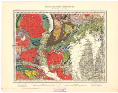
Geologiske kart 58: Den geologiske Undersøgelse, Kristiania
1 : 100000 J. Natrud | J. Schetelig | W. C. Brøgger Norges geologiske undersøkelse
Portefølje nr 23
1 : 100000
Geologisk kart 59: Den geologiske Undersøgelse, Kristianiafeltet-Fet
1 : 100000 W. C. Brøgger | J. Schetelig Norges geologiske undersøkelse
14D Oslo
1 : 100000 Johan Gulbrandsen Natrud | Ole Engh
14D Oslo
1 : 100000 Johan Gulbrandsen Natrud | Ole Engh
14D Oslo
1 : 100000 Johan Gulbrandsen Natrud | Ole Engh
14D Oslo
1 : 100000 Johan Gulbrandsen Natrud | Ole Engh
14D Oslo
1 : 100000 E. Heiberg | H. N. Bergh
14D Oslo
1 : 100000 Johan Gulbrandsen Natrud | Ole Engh
Geologisk kart 1 Den geologiske undersøgelse, Rektangel 14D Kristiania
1 : 100000 Kjerulf Norges geologiske undersøkelse
Geologiske kart 50: Geologisk kart over Christiania omegn
1 : 100000 Theodor Kjerulf
Kartblad 25: Cartt over det Lierske Infanterie Compagnies District
Christian Heubsch
Kartblad 29: Militært Cart over det Askerske Compagnie District
M. Grønvold
Geologisk kart 118: The Aker Moraines
1 : 50000 J. Gjessing Norsk geografisk tidsskrift
1814-1 Asker
1 : 50000 Statens kartverk
1814-4 Lier
1 : 50000 Statens kartverk
1814-4 Lier
1 : 50000 Statens kartverk
1814-4 Lier
1 : 50000 Norges Geografiske Oppmåling
1814-1 Asker
1 : 50000 Statens kartverk
1814-4 Lier
1 : 50000 Norges Geografiske Oppmåling
Geologisk kart 102: Eiker
1 : 100000 Arne Bugge Norges geologiske undersøkelse
14D 5
1 : 50000 Carl Aksel Sigurd Sissener
1814-4 Lier
1 : 50000 Norges Geografiske Oppmåling
Kartblad 23: Kart over det Aggerske Compagnie District
Fridrich Helle Grønvold
14D 9
1 : 50000 Carl Aksel Sigurd Sissener
F35 aust Eiker
1 : 100000
Spesielle kart nr 195. Kopi av kart over kullmilene på Krokskogen.
Conrad Clausen
F35 aust Eiker
1 : 100000
Tysk kart over Eiker (Deutsche Heereskarte)
1 : 50000