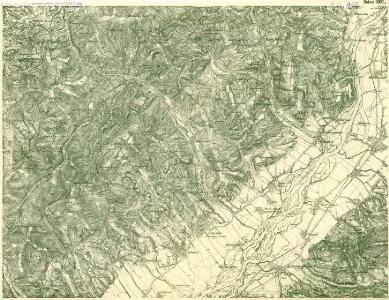
Maps of Mikušovce

III. vojenské mapování 4360/4
1 : 25000
[Gradkartenblatt]
1 : 25000 Slovensko Vojenský zeměpisný ústav
Nedaschow - m1940-1-004 - Kaiserpflichtexemplar der Landkarten des stabilen Katasters
1 : 2880
Nedaschow - m1940-1-006 - Kaiserpflichtexemplar der Landkarten des stabilen Katasters
1 : 2880
Nedaschow - m1940-1-002 - Kaiserpflichtexemplar der Landkarten des stabilen Katasters
1 : 2880
Nedaschow - m1940-1-007 - Kaiserpflichtexemplar der Landkarten des stabilen Katasters
1 : 2880
Nedaschow - m1940-1-005 - Kaiserpflichtexemplar der Landkarten des stabilen Katasters
1 : 2880
Nedaschow - m1940-1-003 - Kaiserpflichtexemplar der Landkarten des stabilen Katasters
1 : 2880
Nedaschow - m1940-1-001 - Kaiserpflichtexemplar der Landkarten des stabilen Katasters
1 : 2880
Orientační mapy. Vlárský průsmyk


III. vojenské mapování 4360
1 : 75000
Wisowitz und Bellus
1 : 75000 Vizovice, Beluša Geripp: Fwkr. Rohn. Rittmeister Mirilović
Vizovice
1 : 75000 Morava (Česko) Vojenský zeměpisný ústav
Vizovice
1 : 75000 Morava (Česko) Vojenský zeměpisný ústav
Vizovice a Beluša
1 : 75000 Morava (Česko) Vojenský zeměpisný ústav
Beluša a Vizovice
1 : 75000 Morava (Česko) Vojenský zeměpisný ústav
Beluša a Vizovice
1 : 75000 Morava (Česko) Vojenský zeměpisný ústav
Wisowitz und Bellus.; Spezialkarte der osterreichisch-ungarischen Monarchie.
from Spezialkarte der osterreichisch-ungarischen Monarchie. Austro-Hungarian Monarchy. Militärgeographisches Institut.,
Mapa okresu uh. brodského
1 : 150000 Uherský Brod-oblast (Česko) Křivánek, K. Růžička, V.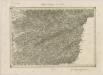
II. vojenské mapování 15
1 : 144000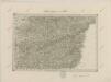
II. vojenské mapování 15
1 : 144000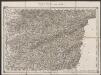
Umgebungen von Zlin
1 : 144000 K.K. Militärisches Geographisches Institut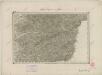
II. vojenské mapování 15
1 : 144000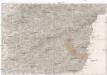
Umgebungen von Zlin
1 : 144000 Zlín (Česko : oblast) K.K. Militärisch-Geographisches Institut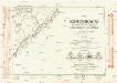
Komunikační mapa země Moravskoslezské
1 : 100000 Trenčín (Slovensko : oblast) Morslez. zem. výbor
Umgebungen Banow und die Höhen Tabelle
1 : 144000 K.K. Militärisches Geographisches Institut
Podrobná mapa Markrabství moravského a Vévodství slezského
1 : 100000 Moravské markrabství Srp, Jan Jos. R. Vilímek

Nedaschowa Lhotta - m1941-1-006 - Kaiserpflichtexemplar der Landkarten des stabilen Katasters
1 : 2880
Nedaschowa Lhotta - m1941-1-003 - Kaiserpflichtexemplar der Landkarten des stabilen Katasters
1 : 2880
Nedaschowa Lhotta - m1941-1-004 - Kaiserpflichtexemplar der Landkarten des stabilen Katasters
1 : 2880
Nedaschowa Lhotta - m1941-1-002 - Kaiserpflichtexemplar der Landkarten des stabilen Katasters
1 : 2880
Nedaschowa Lhotta - m1941-1-001 - Kaiserpflichtexemplar der Landkarten des stabilen Katasters
1 : 2880