Maps of Slaný

Podrobné mapy zemí Koruny české v měřítku 1:75.000 a mapa vzdáleností všech míst při silnici ležících - Velvary - Slaný - Kralupy. Průvodce statisticko-historický po všech místech na těchto mapách uvedených a rejstřík věcný názvů hor, potoků, řek, rybníků atd/ Sešit 12. List 40,
1 : 75000
Podrobné mapy zemí Koruny české v měřítku 1:75.000 a mapa vzdáleností všech míst při silnici ležících
1 : 75000 Kralupy nad Vltavou-oblast (Česko) Bělohlav, Josef Kučera, Karel F. Topič

Gradkartenblatt
1 : 25000 Velvary-oblast (Česko) Albrecht, Julius
Karte des Schlaner Bezirkes im Prager Kreise
1 : 70000 Slaný-oblast (Česko) Wagner, Jan Eduard Karl André
III. vojenské mapování 3852/4
1 : 25000
Plan der Gegend zwischen Tursko und Theresienstadt
1 : 61500 Budyně nad Ohří-oblast (Česko)
Karte des Welwarner Bezirkes im Prager Kreise
1 : 72400 Velvary-oblast (Česko) Wagner, Jan Eduard Karl André
Karte des Welwarner Bezirkes im Prager Kreise
1 : 72400 Velvary-oblast (Česko) Wagner, Jan Eduard Karl André
General-Karte Fürst Kinsky schen Allodialdomäne Zlotnitz
1 : 1400 Zlonice (Česko) Pröhle, Heinrich Kinský, Ferdinand
III. vojenské mapování 3852/3
1 : 25000
Gradkartenblatt
1 : 25000 Louny-oblast (Česko) Bellschan, Anton
Lager in der Gegend vom Georgen-Berg
1 : 100000 Říp (Česko : hora : oblast)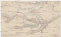
Plan der Gegend von Budin auf 3 Stund in der Länge, und 1/2 Stund in der Breite
1 : 61000 Budyně nad Ohří (Česko) Turati
Podružná dráha z Minkovic do Zvoleňovse
1 : 1000 Kamenný Most (Česko)
Netesch (Netess) - c4768-1-001 - Kaiserpflichtexemplar der Landkarten des stabilen Katasters
1 : 2880
Netesch (Netess) - c4768-1-002 - Kaiserpflichtexemplar der Landkarten des stabilen Katasters
1 : 2880
Netesch (Netess) - c4768-1-005 - Kaiserpflichtexemplar der Landkarten des stabilen Katasters
1 : 2880
Netesch (Netess) - c4768-1-006 - Kaiserpflichtexemplar der Landkarten des stabilen Katasters
1 : 2880
Netesch (Netess) - c4768-1-003 - Kaiserpflichtexemplar der Landkarten des stabilen Katasters
1 : 2880
Netesch (Netess) - c4768-1-004 - Kaiserpflichtexemplar der Landkarten des stabilen Katasters
1 : 2880
Schlan (Slany) - c6996-1-001 - Kaiserpflichtexemplar der Landkarten des stabilen Katasters
1 : 2880
Schlan (Slany) - c6996-1-007 - Kaiserpflichtexemplar der Landkarten des stabilen Katasters
1 : 2880
Schlan (Slany) - c6996-1-004 - Kaiserpflichtexemplar der Landkarten des stabilen Katasters
1 : 2880
Schlan (Slany) - c6996-1-005 - Kaiserpflichtexemplar der Landkarten des stabilen Katasters
1 : 2880
Schlan (Slany) - c6996-1-003 - Kaiserpflichtexemplar der Landkarten des stabilen Katasters
1 : 2880
Schlan (Slany) - c6996-1-006 - Kaiserpflichtexemplar der Landkarten des stabilen Katasters
1 : 2880
Schlan (Slany) - c6996-1-002 - Kaiserpflichtexemplar der Landkarten des stabilen Katasters
1 : 2880
Schlan (Slany) - c6996-1-008 - Kaiserpflichtexemplar der Landkarten des stabilen Katasters
1 : 2880
Perutz (Peruc) - c5709-1-005 - Kaiserpflichtexemplar der Landkarten des stabilen Katasters
1 : 2880
Perutz (Peruc) - c5709-1-008 - Kaiserpflichtexemplar der Landkarten des stabilen Katasters
1 : 2880
Perutz (Peruc) - c5709-1-001 - Kaiserpflichtexemplar der Landkarten des stabilen Katasters
1 : 2880
Perutz (Peruc) - c5709-1-006 - Kaiserpflichtexemplar der Landkarten des stabilen Katasters
1 : 2880
Perutz (Peruc) - c5709-1-002 - Kaiserpflichtexemplar der Landkarten des stabilen Katasters
1 : 2880
Perutz (Peruc) - c5709-1-004 - Kaiserpflichtexemplar der Landkarten des stabilen Katasters
1 : 2880
Perutz (Peruc) - c5709-1-003 - Kaiserpflichtexemplar der Landkarten des stabilen Katasters
1 : 2880


