Maps of Mauritius

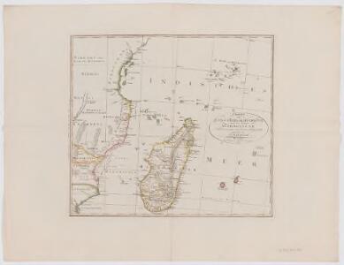
Charte von Zanguebar der Kafferküste und der Insel Madagascar : nach den neuesten und besten Hülfsmitteln
1 : 6800000 Reinecke, J. C. M. (Johann Christoph Matthias), 1770-1818 Im Verlag des Industrie Comptoirs
Cartes générale et particuliéres des isles de France, de Bourbon et de Rodrigue
1 : 2530000 Mauricius Bonne, Rigobert André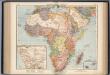
Afrika. Politische Ubersicht
1 : 20000000 Scobel, Albert
A correct map of the African islands of Bourbon, and Mauritius or the Isle of France
1 : 887040
Neue Charte von der Insel Bourbon od Reunion
Réunion Bory de Saint-Vincent, Jean-Baptist Genevieve Marcellin
Neue CHARTE von der Insel BOURBON od REUNION
Réunion Bory de Saint-Vincent, Jean-Baptist Genevieve Marcellin
Isle De La Reunion.
1 : 588000 Levasseur, Victor.
Map of the island of Mauritius
1 : 63360 Mauricius Descubes, A. A. Descubes
CHARTE von ÎLE DE FRANCE oder der Insel Frankreich
Mauricius Bory de Saint-Vincent, Jean-Baptist Genevieve Marcellin
Charte von Ile de France oder der Insel Frankreich
Mauricius Bory de Saint-Vincent, Jean-Baptist Genevieve Marcellin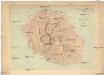
Ile de la Réunion
1 : 100000 Réunion Lépervanche, Paul Samary, Paul Augustin Challamel
Neue Charte von der Insel Bourbon od Reunion
Réunion Bory de Saint-Vincent, Jean-Baptist Genevieve Marcellin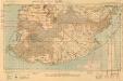
Mauritius, South
[A collection of maps of Mauritius]. [S.l.] : [s.n.]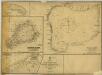
Salomon Islands (1907)
Indian Ocean. Principal Groups of the Chagos Archipelago, by Commander R. Moresby ... 1837. (Salomon Islands. Surveyed ... 1905. Natural scale, 1 : 38,180; Salomon Islands. Entrance to Lagoon. Surveyed ... 1905. Natural scale, 1 : 12,130) [Admiralty Chart]
Plan of the Harbour at the Island Chagos or Diego Garcia
Plan of the Harbour at the Island Chagos or Diego Garcia ... from a survey ... by Lieut. A. Blair. Includes two views of the island of Chagos [Admiralty Chart] [London]
Diego Garica from entrance to East Point.
Diego Garcia from entrance to East Point. Surveyed by Commr. F.C.P. Vereker ... 1885. Natural Scale, 1 : 24,188. (Southern portion. Natural Scale, 1 : 72,560.) [Admiralty Chart] London
Port Louis (1903)
Map of vicinity of Port Louis. Ink and watercolour on paper. The map was subsequently printed as Intelligence Division, War Office, No.1730. -- 'Capt Harrison i/c Survey Sect' ― War Office catalogue. Harrison, William Albert.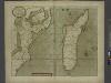
A new draught of the Island of MADAGASCAR ats St. LORENZO with Augustin Bay and the Island of Mombass at Large
from The sea-atlas : containing an hydrographical description of most of the sea-coasts of the known parts of the world.
Carte Particuliere De L'Isle Dauphine ou Madagascar Et St. Laurens, Levée Par Ordre Expres des Roys De Portugal sous qui on en a Fait la Decouverte. [Karte], in: Atlas nouveau, contenant toutes les parties du monde [...], Bd. 2, S. 225.
1 Karte aus Atlas Sanson, Nicolas Jaillot, Alexis Hubert und Mortier, Pieter
Topographical map of the Island of Madagascar
1 : 4580000 from the original design drawn on the spot by M. Roberts S.I. Neele sculpt. London : [s.n.]
Fénérive
1 : 500000 France. Service géographique de l'armée [Tananarive] : Service géographique du Corps d'occupation
Maroantsetra
1 : 500000 France. Service géographique de l'armée [Tananarive] : Service géographique du Corps d'occupation
Vohemar
1 : 500000 France. Service géographique de l'armée Tananarive : Service géographique du Corps d'occupation
Diego-Suarez
1 : 500000 Madagascar. Service géographique [Tananarive] : Service géographique de Madagascar
Diego-Suarez
1 : 500000 Madagascar. Service géographique [Tananarive] : Service géographique de Madagascar
Vohémar
1 : 500000 Madagascar. Service géographique [Tananarive] : Service Géographique de Madagascar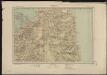
Vohémar
1 : 500000 Madagascar. Service géographique [Tananarive] : Service Géographique de Madagascar
Tamatave
1 : 500000 Madagascar. Service géographique [Tananarive] : Service géographique de Madagascar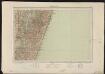
Tamatave
1 : 500000 Madagascar. Service géographique [Tananarive] : Service géographique de Madagascar