Maps of Amazon Basin

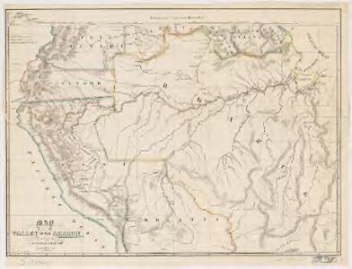
Map of the valley of the Amazon : to accompany Lt. Herndon's report
1 : 6750000 Elliott, H. C A. Hoen
Map of the valley of the Amazon : to accompany Lt. Herndon's report
1 : 6500000 Elliott, H. C. (Henry C.) s.n.
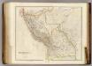
Peru, Amazones.
1 : 10000000 Bowen, Emanuel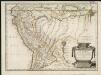
Le Perou
1 : 7033000
Venezuela, New Granada, Ecuador, Peru & Bolivia Chile And Guiana.
1 : 15206400 Johnson, A.J.
Carte du Perou, pour servir à I'histoire des Incas et à celle de l'etat present de cette province
1 : 195000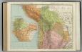
Chile, Bolivia, Peru, Ecuador, Uruguay, Paraguay, Argentine Republic. (northern half).
1 : 5020000 Rand McNally and Company
224-225. South America, North West. The World Atlas.
1 : 7500000 USSR (Union of Soviet Socialist Republics).
Columbian (sic) and Peruvian Republics, etc.
1 : 8400000 Sharpe, J.
Facsimile: Northern Portion of South America.
1 : 9100000 L'Isle, Guillaume de, 1675-1726
Venezuela, New Granada, Equator, Peru.
1 : 9950000 Hughes, William
Mappa del Perù
1 : 3000000 Barrera, Daniel Imprenta Lemercier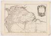
Carte du Pérou et Brésil sepl. de Tierre - Firme, de Guayana, et de la rivière des Amazones : ce qui fait la partie boréale de L'Amérique Meridiole
1 : 6500000 Anville, Jean Baptiste Bourguignon d', 1697-1782 P. Santini, Chez M. Remondini
Peru and Bolivia.
1 : 8200000 Colton, G.W.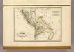
Perou et Bolivia.
1 : 14000000 Malte-Brun, Conrad, 1775-1826
Perou, Bolivie.
1 : 8000000 Garnier, F. A., 1803-1863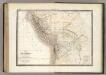
Perou, Haut Perou.
1 : 6800000 Lapie, M. (Pierre), 1779-1850
Peru & Bolivia.
1 : 11200000 Tallis, J. & F.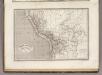
Perou et Bolivia.
1 : 8200000 Montemont, A.
Pérou et pays circonvoisins
1 : 10700000 Peru Bonne, Rigobert André
Perou, Bolivie.
1 : 6000000 Vivien St Martin, L.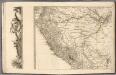
(Sheet 3) Mapa Geografico De America Meridional.
1 : 4335200 Ricarte, Hippolytus
Peru And Bolivia.
1 : 8236800 Colton, G.W.
Peru and Bolivia.
1 : 8000000 Tanner, Henry S.
Peru and Bolivia.
1 : 8200000 Colton, G.W.
Peru.
1 : 8750000 Lucas, Fielding Jr.
Peru.
1 : 5400000 Hall, S. (Sidney)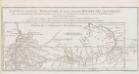
Carte du cours du Maragnon ou de la Grande Riviere des Amazones.
1 : 4000000 En 1743, Charles-Marie de La Condamine, un científico francés que hacía parte de la Expedición Geodésica al Virreinato de Perú, encargada de medir la forma de la Tierra en el Ecuador, emprendió su viaje de regreso a Europa por el Río Amazonas con la intención de corregir los mapas europeos sobre la región Amazónica, y evaluar la presencia real de los españoles y portugueses en la zona. La Condamine compara los resultados de sus cálculos y observaciones con los del jesuita Samuel Fritz, quien había también recorrido el río y publicado en 1707 un mapa titulado “El Gran Rio Marañón, o Amazonas con la Misión de la Compañía de Jesús". En puntillado La Condamine contrasta el trazado del curso del Río y su desembocadura del mapa de Fritz. La Condamine, Charles Marie de (1701-1774)
Peru and Bolivia.
1 : 8200000 Colton, G.W.