Maps of Saint-Octave-de-Métis

Maps of Saint-Octave-de-Métis

$title$

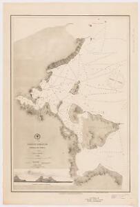
Orange Harbour : Tierra del Fuego

1 : 18700 United States. Hydrographic Office Hydrographic Office
$title$

Schoodic Head

1 : 24000
$title$

Winter Harbor

1 : 24000
$title$

Tunk Mountain

1 : 24000
$title$

Lead Mountain

1 : 24000
$title$

Quillpig Mountain

1 : 24000
$title$

Gassabias Lake

1 : 24000
$title$

Nicatous Lake SE

1 : 24000
$title$

Duck Lake

1 : 24000
$title$

Nicatous Lake NE

1 : 24000
$title$

Bottle Lake

1 : 24000
$title$

Bottle Lake

1 : 24000
$title$

Springfield SE

1 : 24000
$title$

Bowers Mountain

1 : 24000
$title$

Potter Hill

1 : 24000
$title$

Wytopitlock SE

1 : 24000
$title$

Wytopitlock

1 : 24000
$title$

Wytopitlock NE

1 : 24000
$title$

Alder Brook

1 : 24000
$title$

Mattawamkeag Lake SE

1 : 24000
$title$

Mattawamkeag Lake SE

1 : 24000
$title$

Meduxnekeag Lake

1 : 24000
$title$

Smyrna Mills SE

1 : 24000
$title$

Ludlow

1 : 24000
$title$

Ludlow

1 : 24000
$title$

Smyrna Mills NE

1 : 24000
$title$

Howe Brook SE

1 : 24000
$title$

Echo Lake

1 : 24000
$title$

Presque Isle SE

1 : 24000
$title$

Caribou

1 : 24000
$title$

Caribou SE

1 : 24000
© MapTiler © OpenStreetMap contributors
How does it work?
These instructions will show you how to find historical maps online.
Getting started
Type the place name in the search box to find the exact location. You can further adjust the search by zooming in and out.
Zoom
Zoom in and out with the buttons or use your mouse or touchpad natively.
Exact Area tool
Click here and draw a rectangle over the map to precisely define the search area.
Set filters
Narrow your search with advanced settings, such as Years (from/to), Fulltext, Publisher, etc.
Results
See the results of your search on the right side. You can scroll down to find more maps of this location.
?

Download OldMapsOnline Mobile