Maps of Baden-Württemberg

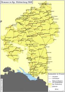
Straßen im Königreich Württemberg 1848
Württemberg Straßennetz Kunz, Andreas ; Treiling, Thomas
Geographica provinciarum Sveviae descriptio
Švábsko (Německo) Hurter, Johann Christoph Bodenehr, Gabriel Hanß Georg Bodenehr
[Geographica provinciarum Sveviae descriptio]
Švábsko (Německo) Hurter, Johann Christoph Bodenehr, Johann Georg bey Hanß Georg Bodenehr
S.R.I. circulus Sueviae continens ducatum Wirtenbergensem alisq. status et provincias eidem circulo insertas
1 : 640000 Württembersko (Německo) Homann, Johann Baptist á Ioh. Bapt. Homanno
Typus ac Synopsis sequentium XXVIII Tabellarum Sveviae = Anweissung und Inhalt über hier nachfolgende XXVIII grosse Tabellen
Mollova mapová sbírka Hurter, Johann Christoph Bodenehr, Gabriel
Typus ac Synopsis sequentium XXVIII Tabellarum Sveviae = Anweissung und Inhalt über hier nachfolgende XXVIII grosse Tabellen
Mollova mapová sbírka Hurter, Johann Christoph Bodenehr, Johann Georg
Cours du Danube feuille I contenant la Suabe ou est exactement marquée la succession de Charles VI
1 Karte : Kupferdruck ; 47 x 55 cm Le Rouge chez le Rouge rue des Augustins vis a vis le Panier Fleuri
Hydrographische Durchlässigkeitskarte des Königreichs Württemberg
1 : 600000 Regelmann, Carl Giesecke & Devrient
S. R. I. Circulus Sueviae Continens Ducatum Wirtenbergensem Aliosq[ue] Status Et Provincias Eidem Circulo Insertas
1 : 620000 Homann, Johann Baptist
Circulus Suevicvs in quo sunt ducatus Wirtenbergensis
1 Karte : Kupferdruck ; 47 x 55 cm Probst J. Michael Probst excud
S. R. I. Circulus Sueviae continens Ducatum Wirtenbergensem
1 : 640000 Mollova mapová sbírka Homann, Johann Baptist Homann, Johann Baptista

La Souabe
1 : 880000 Mollova mapová sbírka Sanson, Nicolas Mariette, Pierre
Circulus Suevicus complectens omnes status subdivisos ex quibus constat
1 Karte : Kupferdruck ; 48 x 57 cm Valck edente Gerardô Valck
Circulus Suevicus : in quo Ducatus Wirtenbergensis cum reliquis Statibus Et Provinciis curate designatus proponitur
Lotter, Tobias Konrad Lotter
Circulus Suevicus in quo sunt ducatus Wirtenbergensis
1 Karte : Kupferdruck ; 48 x 57 cm Danckerts Theodorus Danckerts
Circulus Suevicus
1 : 590000 1 Karte : Kupferdruck ; 49 x 57 cm Danckerts, Theodorus [Danckerts]
Circulus Suevicus
1 Karte : Kupferdruck ; 47 x 56 cm Homann; Funck ex officina Davidis Funck
S.R.I. Sueviae Circulus atq. Ducatus una cum Insertis et Adjacentibus Regionibus, accuratissime in earundem particulares Provincias divisum
1 : 620000 Mollova mapová sbírka Visscher, Nicolaes Schenk, Peter II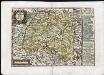
Der Schwäbische Creis
Schreiber, Johann Georg
La Souabe
1 : 870000 Mollova mapová sbírka Sanson, Guillaume Sanson, Guillaume
Circolo di Svevia diviso ne suoi stati
1 Karte : Kupferdruck ; 31 x 40 cm Zatta; Zuliani; Pitteri presso Antonio Zatta
S. R. I. Circulus Sueviae Continens Ducatum Wirtenbergensem Aliosq[ue] Status Et Provincias Eidem Circulo Insertas
Homann, Johann Baptist
Circulus Suevicus in quo Ducatus Wirtenbergensis cum reliquis Statibus et Provinciis curate designatus proponitur
1 : 630000 Mollova mapová sbírka Seutter, Matthäus Seutter, Matthäus
Der schwæbische Kreis. nach dessen neuen Säkularisationen und Entschädigungen entworfen
1 Karte : Kupferdruck ; 46 x 53 cm Walch zufinden bey Joh. Walch
Der schwæbische Kreis. nebst den oesterreichischen Besizungen in Schwaben
1 Karte : Kupferdruck ; 46 x 53 cm Walch zufinden bey Joh. Walch
Circulus Suevicus
1 : 600000 Mollova mapová sbírka Homann, Johann Baptist Funck, David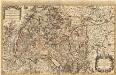
Le Cercle de Souabe subdivisé et tous les Estats qui le composent
1 : 520000 Mollova mapová sbírka Sanson, Guillaume Jaillot, Alexis Hubert
Circulus Suevicus
1 : 600000 Mollova mapová sbírka Wit, Frederik de Wit, Frederick