Maps of West Pomeranian

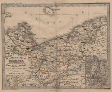
Die Preussische Provinz Pommern, bestehend aus den Regierungs-Bezirken: Stettin, Cöslin & Stralsund
1 : 1850000 Pommern
Pommern.
1 : 600000 Kiepert, Heinrich, 1818-1899
Provinz Pommern
Grosser Hand-Atlas über alle Theile der Erde in 170 Karten Meyer, J. Verlag des Bibliographischen Instituts
Ducatus Pomeraniae novißima tabula
1 : 740000 Pomořansko (Německo a Polsko) Homann, Johann Baptist J. B. Homann
Ducatus Pomeraniae novißima tabula
1 : 802000 Pomořansko (Německo a Polsko) Homann, Johann Baptist Ioh. Bapt. Homann
Ducatus Pomeraniae novißima tabula
1 : 740000 Pomořansko (Německo a Polsko) Homann, Johann Baptist Ioh. Bapt. Homann
Ducatus Pomeraniae novißima tabula
1 : 802000 Pomořansko (Německo a Polsko) Homann, Johann Baptist Ioh. Bapt. Homann
Nova Illustrissimi Ducatus Pomeraniae Tabula [Karte], in: Gerardi Mercatoris et I. Hondii Newer Atlas, oder, Grosses Weltbuch, Bd. 1, S. 322.
1 Karte aus Atlas Mercator, Gerhard und Hondius, Jodocus Jansson, Jan
Pomeraniae Ducatus Tabula. [Karte], in: Theatrum orbis terrarum, sive, Atlas novus, Bd. 1, S. 166.
1 Karte aus Atlas Blaeu, Joan Blaeu, Willem Janszoon
Pommern.
1 : 940000 Flemming, Carl
[...] Pomeraniae Ducatus Tabulam [Karte], in: Novus atlas absolutissimus, Bd. 2, S. 45.
1 Karte aus Atlas Janssonius Offizin
Pomeraniae Ducatus Tabula. [Karte], in: Le théâtre du monde, ou, Nouvel atlas contenant les chartes et descriptions de tous les païs de la terre, Bd. 1, S. 119.
1 Karte aus Atlas Blaeu, Willem Janszoon und Blaeu, Joan Blaeu, Willem Janszoon
Pomeraniae Ducatus Tabula. [Karte], in: Novus Atlas, das ist, Weltbeschreibung, Bd. 1, S. 90.
1 Karte aus Atlas Blaeu, Joan Blaeu, Willem Janszoon
Serenissimo, celsissimo ac invictissimo principi Frederico Guiljelmo, D.G. Marchioni Brandenburgico, S.R.I. electori et archicamerario, etc. Pomeraniae ultori, victori, duci ac reduci hanc Pomeraniae ducatus tabulam / D.D.D. Nicolaus Visscher
1 : 770000 Annotatie: Origineel is Blad 92 in atlas factice; Annotatie geografische gegevens: Met twee schaalstokken: Milliaria Germanica Communia, en: Milliaria Gallica quorum 20 uni gradui respondent Nicolaes Jansz Visscher sr 1618-1679 [Amstelaedami : Nicolaus Visscher]
Nova Illustrissimi Ducatus Pomeraniae Tabula [Karte], in: Novus atlas absolutissimus, Bd. 2, S. 42.
1 Karte aus Atlas Janssonius Offizin
Le Duché De Pomeranie divisé en ses Principales Parties [Karte], in: Atlas nouveau, contenant toutes les parties du monde [...], Bd. 1, S. 332.
1 Karte aus Atlas Sanson, Nicolas Jaillot, Alexis Hubert und Mortier, Pieter
Pommern.
1 : 1250000 Andree, Richard
Preussische Provinz Pommern
Haute Saxe septentrionale.
1 : 750000 Robert de Vaugondy, Gilles, 1688-1766
Preusische Provinz Pommern
1 : 620000 Pomořansko (Německo a Polsko) Kiepert, Heinrich Gräf, A. Geographisches Institut
Pommern.
1 : 1170000 Radefeld, Carl Christian Franz, 1788-1874
Provinz Pommern
1 : 938000 Pomořansko (Německo a Polsko) Handtke, Friedrich C. Fleming
POMERANIÆ | DVCATVS TABVLA
Auctore | Eilhardo Lubino. S. Rogiers sculpsit [Amsterdam : Joan Blaeu]
Tabula generalis totius Pomeraniae.....

Tabula generalis totius Pomeraniae tam Suecicae quam Brandenburgicae, ad priorem ducatus Bardens. et comit. Gutzkoviensis, nec non adjacens insula Rugia, ad posteriorem ducatus Pomeraniae proprie sic. dict. Stettinensis, Cassubiae, Vandaliae, et dominia Louwenburgense Wolgastense, Butoviense etc. pertinent
ad hodiernum usum diligenter exarata sumptibus Tob. Conr. Lotter Matthaeus Albrecht Lotter, fil[ius] sculps. Aug. Vind : Tob. Conr. Lotter

Tabula marchionatus Brandenburgici et ducatus Pomeraniae quae sunt pars septentrionalis circuli Saxoniae superioris
1 : 1000000 Braniborsko (Německo) Homann, Johann Baptist J. B. Homann
Tabula marchionatus Brandenbvrgici et dvcatvs Pomeraniae quae sunt pars septentrionalis circvli Saxoniae svperioris
1 : 1100000 Braniborsko (Německo) Homann, Johann Baptist a Ioh. Baptista Homanno
Tabula marchionatus Brandenburgici et ducatus Pomeraniae quae sunt pars septentrionalis circuli Saxoniae superioris
1 : 1000000 Braniborsko (Německo) Homann, Johann Baptist Ioh. Baptista Homanno