Maps of Rostov

[Südrussland]
1 : 1500000 Don-Gebiet, Jekaterinoslaw (Gouvernement)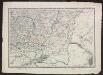
Voenno-dorožnaja karta časti Rossii i pograničnych zemelʹ
1 : 1680000 Ukraine, Don-Gebiet Šubert [Generalmajor]
Partie, Russie d'Europe. Europe 16.
1 : 1641836 Vandermaelen, Philippe, 1795-1869
Das Vordringen des Carenreiches in die südrussische Steppe und die Neordnung der Südbezirke bis 1774
Ukraine (Süd), Neurussland, Verwaltungsgliederung Anton, J.
[Asov]
1 Karte : Kupferdruck ; 18 x 13 cm [Trattner]
Südlicher Theil des Saratowschen Gouvernements mit dem See Elton und den Salzstrassen
Russland, Saratow (Gouvernement), Verkehrswege
Osteuropa 1:300 000
1 : 300000 Kursk-oblast (Rusko) OKH
Porogen des Dnjepr
1 : 2400000 Dnjepr Flusslauf, Stromschnelle
TRACTVS | BORYSTHENIS | Vulgo DNIEPR et NIEPR dicti, | à BOVZIN usque ad CHORTYCA OSTROW.
Amstelædami, Excud. Ioannes Blaeu.
Carte des embouchures du Tanais et des environs depuis Taigan, jusqu'a Nova-Krepa / Croisey scul.
1 : 310000 1 Karte : Kupferdruck ; 17 x 23 cm Bellin, Jacques Nicolas [Bellin]
Aus dem Nowochoper Kreise des Gouv. Woronesh
Russland Gouvernement Woronesch Khoper Novochopërsk Deutsche
Plan sraženīja pri Poltavě
Ukraine Poltawa Nordischer Krieg <1700-1721> Poltawa / Schlacht
Überreste der Stadt Sarai in der Nähe von Zarew, nördlich der Achtuba, eines Armes der Wolga
Sarai Archäologische Stätte, Goldene Horde
Plan Novoj Siči
Ukraine Saporoschje (Region) Saporoger Kosaken
Plan d'Azak où Azof / Croisey scul.
1 : 35000 1 Karte : Kupferdruck ; 21 x 16 cm Bellin, Jacques Nicolas [Bellin]
Moscowitische belagerung und Eroberung der Haubt-Stadt Asoff, im Tartarischen Königreich Nagaja am
1 Vogelschaukt. : Kupferdruck ; 26 x 34 cm Merian, Caspar [Merian's Erben]
Okrestnosti g. Orla i verchov'ja r. Oki
Russland Zentralrussland Orel Oka
Cvmania Magna olim Hvnnia Orientalis
1 : 6500000 Mollova mapová sbírka
Taurica Chersonesus, Hodie Przecopsca, et Gazara dicitur. [Karte], in: Novus atlas absolutissimus, Bd. 1, S. 113.
1 Karte aus Atlas Janssonius Offizin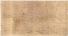
[Ukrajina - vrstevnice a říční síť]
Ukrajina
Governi di Moscovia e Woronez colle loro provincie nella Russia europea
1 Karte : Kupferdruck ; 41 x 32 cm Zatta; Zuliani; Pitteri presso Antonio Zatta
Governi di Moscovia e Woronez colle loro provincie nella Russia europea / G. Zuliani inc. ; G. Pitte
1 : 3500000 1 Karte : Kupferdruck ; 41 x 32 cm Zuliani, Giuliano presso Antonio Zatta
I governi di Moscovia e Woronez nell'impero della Russia in Europa / Gio. Ma. Cassini som.co. inc.
1 : 3500000 1 Karte : Kupferdruck ; 44 x 31 cm Cassini, Giovanni Maria Presso la Calcografia Camerale
Nouvelle carte des etats du grand duc de Moscovie en Europe partie meridionale
1 : 3700000 1 Karte : Kupferdruck ; 34 x 45 cm Châtelain, Zacharias [Verlag nicht ermittelbar]
TAVRICA CHERSONESVS | Nostra ætate | PRZECOPSCA, | et GAZARA dicitur.
[Amsterdam : Joan Blaeu]
Südliches Blatt vom Europ. Russland
Hand-Atlas über alle Theile der Erde nach dem neuesten Zustande und über das Weltgebäude Stieler, Adolf bei Justus Perthes

Partie meridionale de Moscovie / dressée par G. de L'Isle
1 : 3200000 1 Karte : Kupferdruck ; 40 x 55 cm L'Isle, Guillaume de chez Ian Barend Elwe
Schema podrazdělenīj srednerusskoj i okružajuščich vozvyšennostej i nizmennostej
Russland Geografie
![[Südrussland]](https://images-2.georeferencer.com/images/iiif/383156424566/full/,300/0/native.jpg)

