Maps of Klaipeda
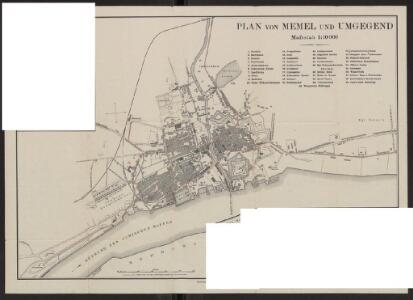
Plan von Memel und Umgegend
Litauen Memel Klaipėda H. Wagner & E. Debes (Leipzig)
Messtischblatt 292 : Memel, 1942 Memel
1 : 250000 Memel. - Aufnahme 1910, berichtigt 1940, hrsg. 1912.. - 1:25000. - [Berlin]: Reichsamt für Landesaufnahme, 1942. - 1 Kt.
[Nebenkarte Kgl. Schmelz]
Litauen Memelland Memel Stadtviertel Stadtplan
3. Memel. (Germany)
1 : 100000 Reichsamt fur Landesaufnahme
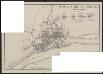
[Umgebungsplan Memel]
1 : 300000 Litauen Ostpreußen Memel Umland
Composite: 3. Memel. (Germany)
1 : 100000 Reichsamt fur Landesaufnahme
Ostsee
1 : 70000 Baltské moře Reichs-Marine-Amt
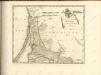
Sect. 2. Memel (Das Curische Haff nördl. Theil), uit: Geologische Karte der Provinz Preussen
1 : 100000 Annotatie: Incompleet; Voor aanwezige bladen zie bladoverzicht; Met inzetkaarten; Annotatie geografische gegevens: Coördinaten gebaseerd op nulmeridiaan van Ferro (Hierro) Berlin : Neumann
1. Memel, uit: Topographische Uebersichtskarte des Deutschen Reiches / herausgegeben v. d. Kartogr. Abt. d. Königl. Preuß. Landesaufnahme
1 : 200000 titelvariant: Topogr. Übersichtskarte des Deutschen Reiches; Annotatie: Titel boven bladen ook: Topogr. Übersichtskarte des Deutschen Reiches; Annotatie geografische gegevens: Op elk blad twee maatstokken: 10 Kilometer = 5,5 cm; 1 geogr. Meile = 3,6 cm; Legenda onder op elk blad Königlich Preußische Landesaufnahme. Kartographische Abtheilung [S.l : Königlich Preußische Landesaufnahme, Kartographische Abtheilung]
Die Kurische Nehrung und ihre Umgebung
1 : 300000 Russland Litauen Kurische Nehrung Bezzenberger, Adalbert
Ostsee
1 : 150000 Baltské moře Reichs-Marine-Amt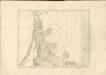

Potentissimo BORUSSORUM REGI FRIDERICO WILHELMO, Majestate, Fortitudine Clementia Augustissimo
1 : 200000 Kaliningrad-oblast (Rusko) Betgen, Johann F. Homanniani Heredes
Ostsee
1 : 150000 Baltské moře Reichs-Marine-Amt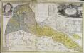
Dvcatvs Cvrlandiæ jux.ta Barnikelii architecti curici primarii geometricam delineationem geographica tabula expressus
1 Karte : Kupferdruck ; 47 x 34 cm Barnickel Homännische Erben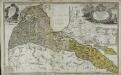
Dvcatvs Cvrlandiæ jux.ta Barnikelii architecti curici primarii geometricam delineationem geographica tabula expressus
1 Karte : Kupferdruck ; 48 x 34 cm Barnickel Homännische Erben
Provinz Ostpreussen
1 : 1250000 Ostpreußen
Litauisch und Masurisch
Ostpreußen Litauisch, Masurisch
Prvssia
1 Karte : Kupferdruck ; 35 x 47 cm Mercator; Hondius Henricus Hondius
Ost-Preussen.
1 : 935000 Flemming, Carl

Übersichtskarte von Mittel - Europa

Provinz Ost - Preussen

Riga, Libau, Memel, Kowno
1 : 750000 Kaunas (Litva) K. u. k. Militärgeographisches Institut
Regnum Borussiae gloriosis auspiciis serenissimi et potentissimi princip. Friderici III primi Borussiae regis march. et elect. Brandenburg inauguratum die 18 Jan A 1701
1 : 760000 Prusko Homann, Johann Baptist J.B. Homann
REGNUM BORUSSIAE Gloriosis auspiciis Serenissimi et Potentissimi Pri. FRIDERICI III PRIMI BORUSSIAE REGIS, MARCH. ET ELECT. BRAN. inauguratum die 18. Ian A. 1701 Geographice cum vicinis Regionibus adumbratum
1 : 750000 Prusko Homann, Johann Baptist a Ioh. Baptista Homanno
Regnum Borussiae gloriosis auspiciis serenissimi et potentissimi prin Friderici III primi Borussiae regis, march. et elect. Brandenburg inauguratum die 18. Ian A. 1701
1 : 760000 Prusko Homann, Johann Baptist a Ioh Baptista Homanno
Regnum Borussiae gloriosis auspiciis serenissimi et potentissimi prin Friderici III primi Borussiae regis, march. et elect. Bran inauguratum die 18. Ian. A. 1701
1 : 760000 Prusko Homann, Johann Baptist a Ioh. Baptista Homanno
Regnum Borussiae gloriosis auspiciis serenissimi et potentissimi princ. Friderici III primi Borussiae regis, march. et elect. Brand. inauguratum die 18. Ian. A. 1701
1 : 760000 Prusko Homann, Johann Baptist a Ioh. Baptista Homanno