Maps of Turan Lowland
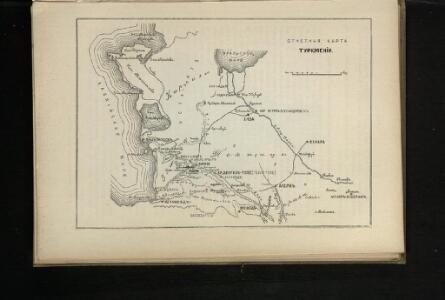
Otčetnaja karta Turkmenīi
Turkmenistan Eroberung
Nova et accuratissima maris Caspii hactenus maximam partem nobis non satis cogniti ac regionum adjacentium delineat
1 Karte : Kupferdruck ; 48 x 56 cm Probst; Seutter anjezo in Verlag bey Iohann Michael Probst Chalcogr. in Augspurg
28-29. Uzbek SSR and Turkmen SSR. The World Atlas.
1 : 3000000 USSR (Union of Soviet Socialist Republics).
Turkmenskaja SSR: Osnovnyje objekty promyšlennogo, transportnogo i selskochozjaistvennogo stroitelstva, postroennye i načatye stroitelstvom do načala treťej pjatiletki
Kalmykov, V. A.
Vierte Revolution des Caspischen Meeres, oder Karte des Czar Peter des Grossen
1 Karte : Kupferdruck ; 20 x 29 cm Anville Philipp Heinrich Perrenon

No.30. Karta Evropeyskaia Rossiia. Sheet 16
1 : 2000000 Shokalskago,Iu. M.
Caspian Sea.
1 : 4530000 Orbeliani, Sulxan-Saba, 1658-1725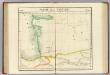
Partie, la Tartarie. Asie 53.
1 : 1641836 Vandermaelen, Philippe, 1795-1869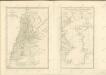

Essai d'une nouvelle carte de la mer Caspienne
1 Karte : Kupferdruck ; 51 x 25 cm Anville; Delahaye s.n.
A new and accurate map of the Caspian sea
1 Karte : Kupferdruck ; 31 x 21 cm Bowen s.n.
Carte marine de la mer Caspiene
1 Karte auf 2 Blatt : Kupferdruck ; 86 x 60 cm Verden; L'Isle chez le Sr. Delisle quay de l'horloge
Geographica nova ex oriente gratiosissima, duabus tabulis specialissimis contenta quarum una mare Caspivm altera Kamtzadaliam seu terram Jedso curiosè exhibe[n]t
2 Karten auf 1 Blatt : Kupferdruck ; Bildgrösse 48 x 56 cm Homann editore Io. Bapt. Homann S. C. M. geogr
A new and accurate map of the Caspian sea / by Eman.l Bowen
1 : 4400000 1 Karte : Kupferdruck ; Bowen, Emanuel [Printed for William Innys and Joseph Richardson ... [et al.]]
Geographica nova ex oriente gratiossima, duabus tabulis specialissimis contenta, quarum una mare Caspivm, alt[e]ra Kamtzadaliam se[u] terram Jedso curiosé [e]xhibe[n]t
Kamčatka (Rusko) Homann, Johann Baptist Io. Bapt. Homann
Feuille 35 (G V), uit: Carte géologique internationale de l'Europe : la carte, votée au congrès géologique international de Bologne en 1881, est exécutée conformément aux décisions d'une commission internationale, avec le concours des gouvernements, sous le dir. de M.M. Beyrich et Hauchecorne
Annotatie: Blad 48 gamme des couleurs; blad 49: bladwijzer en titelblad Heinrich Ernst Beyrich 1815-1896; Wi. Hauchecorne Berlin : Reimer / (Berlin: Institut lithographique)
Nova et accuratissima Maris Caspii
1 : 1910000 Kaspické moře Seutter, Matthäus Matth. Seutter
Karte von dem Caspischen Meer / nach Pr. Güldenstaedts Entwurf ; gezeichnet von J. Wussin ; herausg
1 : 3100000 1 Karte : Kupferdruck ; 48 x 26 cm Schraembl, Franz Anton zu finden in eigenem Verlage [Schrämbl]
Essai d'une nouvelle carte de la mer Caspienne / par le Sr. d'Anville de l'Acad. r.le des inscript.
1 : 2400000 1 Karte : Kupferdruck ; 51 x 25 cm Anville, Jean Baptiste Bourguignon d' [Verlag nicht ermittelbar]
Carte de la mer Caspiene
1 : 3000000 1 Karte : Kupferdruck ; 44 x 22 cm L'Isle, Guillaume de [Verlag nicht ermittelbar]
Geographica nova ex oriente gratiosissima, duabus tabulis specialissimis contenta quarum una mare Ca
1 : 2500000 2 Karten auf 1 Blatt : Kupferdruck ; 48 x 56 cm Homann, Johann Baptist editore Io. Bapt. Homann S. C. M. geogr.
Carte marine de la mer Caspiene / levée suivant les ordres de S. M. czariene, par Mr. Carl Vanverde
1 : 1600000 1 Karte auf 2 Blatt : Kupferdruck ; 47 x 62 cm und 43 x 62 cm Verden, Carl van chez le Sr. Dezauche Géogr. Rue des Noyers
Carte de la mer caspienne / dressée en 7.bre 1776 d'après les dernieres observations par D. Gulden
1 : 5300000 1 Karte : Kupferstich ; 24 x 14 cm Tardieu, Pierre-François Froullé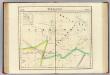
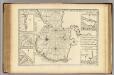
Turkestan. Asie 54.
1 : 1641836 Vandermaelen, Philippe, 1795-1869
[Xiva]
Usbekistan Xiva Eroberung
Russian Empire in Eastern & Western Asia.
1 : 3000000 Fullarton, A. & Co.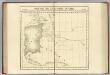
Partie, Russie d'Asie. Asie 41.
1 : 1641836 Vandermaelen, Philippe, 1795-1869
Portions of the Russian empire in eastern and western Asia / drawn by Augustus Petermann F.R.G.S. ;
1 : 3000000 2 Karten auf einem Blatt : Mehrfarbendruck ; 33 x 48 cm Petermann, A. A. Fullarton