Maps of Thüringen
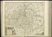
[42][42]Circuli Saxoniae Superioris pars meridionalis ..., uit: Atlas sive Descriptio terrarum orbis
Annotatie: Gedigitaliseerde versie. Amsterdam. Heiloo : Picturae (vervaardiger), 2015. tiff-bestand. Gedigitaliseerd: 07-01-2015; Origineel: Universiteitsbibliotheek Vrije Universiteit (XL.05127.-) ; Netherlands; Titelpagina ontbreekt Wit, Frederik de Amsterdam : Frederick de Wit

1:500,000 Europe (Air) G.S.G.S. No. 4072, Leipzig
Sheet NE50-10 from the map series: 1:500,000 Europe (Air) G.S.G.S. No. 4072.
[No. 5. Allemagne, Saxe], uit: [Carte de l'Europe]
1 : 490000 Paris : Piquet
Neueste Charte vom Königreich Sachsen
1 : 683000 Sasko (Německo) Walch, Johann J. Walch
CIRCULI SAXONIAE SUPERIORI[S]
1 : 620000 Anhaltsko (Německo) Wit, Frederick de F. de Wit
Circuli Saxoniae superiori[s] pars meridionalis
1 : 620000 Anhaltsko (Německo) Danckerts, Justus per Iustinum Danckerts
Circuli Saxoniae superiori[s] pars meridionalis
1 : 600000 1 Karte : Kupferdruck ; 47 x 55 cm Danckerts, Justus [Danckerts]
Haute Saxe meridionale.
1 : 600000 Robert de Vaugondy, Gilles, 1688-1766
Mittel Deutschland
Neuer Handatlas über alle Theile der Erde Kiepert, Heinrich Verlag von Dietrich Reimer
Thuringen u. Sachsen.
1 : 600000 Gutbier, Ludwig von
Charte von dem Königreiche Sachsen
1 : 673000 Sasko (Německo) Zuccheri, Edmund von im Verlage des Kunst und Industrie Comptoirs
Charte von dem Königreiche Sachsen
1 : 673000 Sasko (Německo) Zuccheri, Edmund von im Verlage des Kunst und Industrie Comptoirs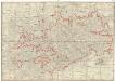
Post-Charte des Königreich Sachsen und der angränzenden Ländern
1 : 430000 Sasko (Německo) Güssefeld, Franz L. Geographisches Institut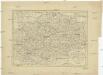
Charte des Königreichs Sachsen
1 : 965000 Sasko (Německo)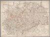
Das Königreich Sachsen mit den Kurfürstlich- und Herzoglich- Saechsischen Laendern / ... neu entw. von D.F. Sotzmann
1 : 600000 Sotzmann, Daniel Friedrich Nürnberg : Schneider u. Weigelschen Kunst u. Buchhandlung
Charte vom Königreich Sachsen
1 : 694000 Sasko (Německo) Güssefeld, Franz L. Christoph Fembo
Saxoniae Superioris praesertim electoralis circulus, cum adjacentibus ducatibus et provinciis simulque diligentissime annotatis postarum cursus et stationes mappa geographica
1 : 500000 recens et accurata delineata per Tob. Conradum Lotter Aug. Vindel. : per Tob. Conradum Lotter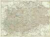
Karte von den Kurfürstlich- und Herzöglich- Saechsischen Laendern
1 : 550000 Sasko (Německo) von den k. k. privileg. Schneider u. Weigelschen Kunst u. Buchhandlung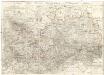
Oro-hydro-graphische general Charte von Königreiche Sachsen und den angrenzenden Ländern
1 : 450000 Sasko (Německo) Rühle von Lilienstern, Johann Jakob Otto August Keyl, Christian Karl Maximilian in der Rittnerschen Kunsthandlung
Das Königreich Sachen
Neuester Schul-Atlas Walch, Johann im Verlag bei Joh. Walch
Saxoniae Electoralis, Finitimarumque Provinciarum Nova et Antea nunquam edita delineatio
1 : 730000 Mollova mapová sbírka Schenk, Pieter Schenk, Peter I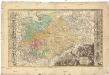
Dvcatvs electorat[us] et principat[us] dvcvm Saxoniae
1 : 462500 Sasko (Německo) Zollmann, Friedrich Zollmann, Philipp Heinrich ab Homannianis Heredibvs
Saxoniae, Misniae, Thvringiae, nova exactissimaq[ue] descriptio
1 Karte : Kupferdruck ; 31 x 47 cm Ortelius s.n.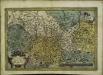
Saxoniae, Misniae, Thvringiae, nova exactissimaq[ue] descriptio
1 Karte : Kupferdruck ; 32 x 48 cm Ortelius s.n.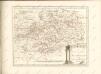

Sachsen, Thüringen und Benachbarte Laender
Hand-Atlas über alle Theile der Erde nach dem neuesten Zustande und über das Weltgebäude Stieler, Adolf bei Justus Perthes
Sachsen, Thuringische Staaten.
1 : 870000 Andree, Richard
![[42][42]Circuli Saxoniae Superioris pars meridionalis ..., uit: Atlas sive Descriptio terrarum orbis](https://images-2.georeferencer.com/images/iiif/423611726152/full/,300/0/native.jpg)

