Maps of Pagėgių savivaldybė

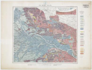
Sect. 4. Tilsit (Das Memel Delta (Schalaunen)), uit: Geologische Karte der Provinz Preussen
1 : 100000 Annotatie: Incompleet; Voor aanwezige bladen zie bladoverzicht; Met inzetkaarten; Annotatie geografische gegevens: Coördinaten gebaseerd op nulmeridiaan van Ferro (Hierro) Berlin : Neumann
Meßtischblatt 0997 : Tilsit, 1927
1 : 250000 Tilsit. - Hrsg. 1915, einzl. Nachtr. 1927. - 1:25000. - [Berlin]: Reichsamt für Landesaufnahme, 1927. - 1 Kt.
Meßtischblatt 0995 : Neukirch, 1938
1 : 250000 Neukirch. - Aufn. 1912, hrsg. 1914, letzt. Nachtr. 1938. - 1:25000. - [Berlin]: Reichsamt für Landesaufnahme, 1938. - 1 Kt.
Meßtischblatt 0994 : Rauterskirch, 1938
1 : 250000 Rauterskirch. - Hrsg. 1914, kl. Nachtr. 1925, redakt. Änd. 1938. - 1:25000. - [Berlin]: Reichsamt für Landesaufnahme, 1938. - 1 Kt.
Meßtischblatt 0996 : Heinrichswalde, 1937
1 : 250000 Heinrichswalde. - Aufn. 1914, einz. Nachtr. 1928. - 1:25000. - [Berlin]: Reichsamt für Landesaufnahme, 1937. - 1 Kt.
Meßtischblatt 0897 : Pogegen, 1940
1 : 250000 Pogegen. - Aufn. 1913, hrsg. 1915, letzt. Nachtr. 1940. - 1:25000. - [Berlin]: Reichsamt für Landesaufnahme, 1940. - 1 Kt.
Meßtischblatt 0895 : Kuckerneese, 1939
1 : 250000 Kuckerneese. - Hrsg. 1914, einzl. Nachtr. 1928, redakt. Änd. 19. - 1:25000. - [Berlin]: Reichsamt für Landesaufnahme, 1939. - 1 Kt.
Meßtischblatt 62 : Spucken, 1937
1 : 250000 Spucken. - Hrsg. 1914, einzelne Nachtr. 1928, [Druckvermerk] 36. - 1:25000. - [Berlin]: Reichsamt für Landesaufnahme, 1937. - 1 Kt.
Meßtischblatt 0896 : Rucken, 1940
1 : 250000 Rucken. - Aufn. 1912, hrsg. 1914, letzt. Nachtr. 1939/40. - 1:25000. - [Berlin]: Reichsamt für Landesaufnahme, 1940. - 1 Kt.
Meßtischblatt 0797 : Nattkischken, 1939
1 : 250000 Nattkischken. - Hrsg. 1915, redakt. Änd. 1939. - 1:25000. - [Berlin]: Reichsamt für Landesaufnahme, 1939. - 1 Kt.
Meßtischblatt 0795 : Uszlöknen, 1940
1 : 250000 Uszlöknen. - Aufn. 1912, hrsg. 1914, letzt. Nachtr. 1940. - 1:25000. - [Berlin]: Reichsamt für Landesaufnahme, 1940. - 1 Kt.
Meßtischblatt 0794 : Ruß, 1938
1 : 250000 Ruß. - Hrsg. 1912, einzelne Nachtr. 1927, red. Änd. 193. - 1:25000. - [Berlin]: Reichsamt für Landesaufnahme, 1938. - 1 Kt.
Meßtischblatt 0796 : Coadjuthen, 1914
1 : 250000 Coadjuthen. - Aufn. [1897 ?], hrsg. 1914. - 1:25000. - [Berlin]: Reichsamt für Landesaufnahme, 1914. - 1 Kt.
Messtischblatt 0694 : Heydekrug, 1940 Heydekrug
1 : 250000 Heydekrug. - Aufn. 1910, hrsg. 1912, letzte Nachtr. 1940. - 1:25000. - [Berlin]: Reichsamt für Landesaufnahme, 1941. - 1 Kt.
Meßtischblatt 0695 : Gaidellen, 1939
1 : 250000 Gaidellen. - Hrsg. 1914, redakt. Änd. 1939. - 1:25000. - [Berlin]: Reichsamt für Landesaufnahme, 1939. - 1 Kt.
Meßtischblatt 0696 : Wersmeninken, 1939
1 : 250000 Wersmeninken. - Hrsg. 1914, redakt. Änd. 1939. - 1:25000. - [Berlin]: Reichsamt für Landesaufnahme, 1939. - 1 Kt.
Meßtischblatt 32, neue Nr. 0697 : Ackmonischken, 1939
1 : 250000 Ackmonischken. - Hrsg. 1915, redakt. Änd. 1939. - 1:25000. - [Berlin]: Reichsamt für Landesaufnahme, 1939. - 1 Kt.
Meßtischblatt 0798 : Uszkullmen, 1939
1 : 250000 Uszkullmen. - Hrsg. 1915, redakt. Änd. 1939. - 1:25000. - [Berlin]: Reichsamt für Landesaufnahme, 1939. - 1 Kt.
Meßtischblatt 0898 : Willkischken, 1941
1 : 250000 Willkischken. - Aufn. 1913, hrsg. 1915, letzt. Nachtr. 1940, Aus. - 1:25000. - [Berlin]: Reichsamt für Landesaufnahme, 1941. - 1 Kt.
Meßtischblatt 0998 : Ragnit, 1939
1 : 250000 Ragnit. - Aufn. 1913, hrsg. 1915, letzt. Nachtr. 1939. - 1:25000. - [Berlin]: Reichsamt für Landesaufnahme, 1939. - 1 Kt.
Composite: 31. Skaisgirren. (Germany)
1 : 100000 Reichsamt fur Landesaufnahme
10. Medischkehmen. (18. Tilsit). (Germany)
1 : 100000 Reichsamt fur Landesaufnahme
Composite: 10. Medischkehmen. (18. Tilsit). (Germany)
1 : 100000 Reichsamt fur Landesaufnahme
Tilsit 8, uit: Special-Karte von Mittel-Europa / nach amtlichen Quellen bearbeitet von W. Liebenow
1 : 300000 titelvariant: W. Liebenow's Mittel-Europa; Annotatie: Titel boven de bladen: W. Liebenow's Mittel-Europa Johannes Wilhelm Liebenow 1822-1897 Frankfurt a. M. : Ludwig Ravenstein
Potentissimo BORUSSORUM REGI FRIDERICO WILHELMO, Majestate, Fortitudine Clementia Augustissimo
1 : 200000 Kaliningrad-oblast (Rusko) Betgen, Johann F. Homanniani Heredes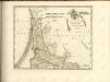
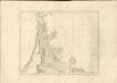

Die Kurische Nehrung und ihre Umgebung
1 : 300000 Russland Litauen Kurische Nehrung Bezzenberger, Adalbert
Sect. 8. Insterburg (Nadrauen), uit: Geologische Karte der Provinz Preussen
1 : 100000 Annotatie: Incompleet; Voor aanwezige bladen zie bladoverzicht; Met inzetkaarten; Annotatie geografische gegevens: Coördinaten gebaseerd op nulmeridiaan van Ferro (Hierro) Berlin : Neumann