Maps of Highland

[Kaart], uit: Bartholomew's general map of Scotland / The Edinburgh Geographical Institute
1 : 633600 Annotatie geografische gegevens: Inzet: Orkney and Shetland islands on a reduced scale. - [ca. 1:1.840.000] The Edinburgh Geographical Institute, Edinburgh Edinburgh [etc.] : Bartholomew
[Kaart], uit: Bartholomew's general map of Scotland
1 : 633600 Edinburgh : Bartholomew [etc.]
Naturalist's map of Scotland
1 : 633600 Harvie-Brown, John Alexander ; Bartholomew, John [John Bartholomew]
Scotland.
1 : 1500000 Colton, G.W.
Scotland.
1 : 1500000 Colton, G.W.
Scotland.
1 : 1225000 Teesdale, Henry
A map of Scotland
1 : 1250000 Skotsko Virtue, George Starling, Thomas George Virtue
Scotland.
1 : 1500000 Colton, G.W.
Scotland.
1 : 1760000 Finley, Anthony
Scotland.
1 : 775000 Arrowsmith, John
Scotland.
1 : 1584000 Colton, G.W.
Scotland.
1 : 1800000 Tanner, Henry S.
Scotland.
1 : 1000000 Andree, Richard; Times (London, England)
Scotland.
1 : 800000 Thomson, John
Scotland.
1 : 1010000 Hall, S. (Sidney)
Scotland.
1 : 1013760 Letts, Son & Co.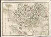
Scotland with its Islands
A new general atlas of modern geography, consisting of a complete collection of maps of the four quarters of the globe Wyld, James James Wyld
Scotland.
1 : 1800000 Finley, Anthony
Scotland.
1 : 760320 Arrowsmith, John
Composite: Scotland.
1 : 633300 Johnston, Alexander Keith
First sketch of a new geological map of Scotland
1 : 1600000 Murchison, Roderick Impey ; Geikie, Archibald ; Johnston, Alexander Keith Johnston and Blackwood
Composite: Scotland.
1 : 633300 Johnston, Alexander Keith
SCOTIA REGNUM
1 : 870000 Skotsko Wit, Frederick de ex Officina Frederici de Witt
Scotland.
1 : 1013760 Fullarton, A. & Co.
Scotia Regnum : divisum in partem Septentrionalem et Meridionalem : subdivisas in comitatus, vicecomitatus, provincias, praefecturas, dominia et insulas
1 : 800000 per F. de Wit. [Amsterdam] : F. de Wit
Index map.
1 : 1200000 Thomson, John
[Kaart], uit: Scotland / The London Geographical Institute
1 : 570000 Annotatie: Reeksvariant vermeld als: Philip's new series of imperial maps for tourists & travellers; Annotatie geografische gegevens: Inzet: Shetland Island; Edinburgh & vicinity The London Geographical Institute, London [London : George Philip & Son]

L'Ecosse
1 Karte : Kupferdruck ; 54 x 47 cm Le Rouge; Basset; Basset chez Basset rue Saint Jacques
Nova et accurata totius regni Scotiæ, secundum omnes provincias et adjacentes insulas, exquisito studio determinatæ, delineatio
1 Karte : Kupferdruck ; 56 x 48 cm Lotter; Silbereisen Tobias Konrad Lotter
L'Ecosse
1 Karte : Kupferdruck ; 54 x 47 cm Le Rouge; Bowles chés le Sr. le Rouge ingen.r géog. du roy rue des grands Augustins
Nova et accurata totius regni Scotiæ, secundum omnes provincias et adjacentes insulas, exquisito studio determinatæ, delineatio
1 Karte : Kupferdruck ; 56 x 48 cm Seutter; Silbereisen Matthäus Seutter
Scotia regnum
1 Karte : Kupferdruck ; 56 x 49 cm Wit ex officina J. Cóvens et C. Mortier
Novissima regni Scotiæ septentrionalis et meridionalis tabula
1 Karte : Kupferdruck ; 49 x 58 cm by I. Cóvens en C. Mortier op de Vygendam
Scotia Cambdeni et Sibbaldi
1 Karte : Kupferdruck ; 37 x 31 cm Weigel; Camden; Sibbald; Kauffer Christoph Weigel
Novissima regni Scotiæ septentrionalis et meridionalis tabula
1 Karte : Kupferdruck ; 56 x 48 cm Schenk Pieter Schenk
Nouvelle carte d'Ecosse
1 Karte : Kupferdruck ; 33 x 31 cm Châtelain s.n.
Regnum Scotiæ, seu pars septent: Magnæ Britanniæ
1 Karte : Kupferdruck ; 46 x 58 cm Valck; Valck G. und L. Valck
Magnæ Britanniæ pars septentrionalis qua regnum Scotiæ in suas partes et subjacentes insulas divisum accurata tabula
1 Karte : Kupferdruck ; 56 x 46 cm Visscher; Homann Johann Baptist Homann
Le royaume d'Escosse
1 Karte auf 2 Blatt : Kupferdruck ; 84 x 57 cm Sanson; Jaillot chez H. Jaillot
Scotia regnum
1 Karte : Kupferdruck ; 56 x 49 cm Wit ex officina Frederici de Witt
Scotia regnvm
1 Karte : Kupferdruck ; 37 x 49 cm Janssonius apud Ioannem Ianssonium
Novissima regni Scotiæ septentrionalis et meridionalis tabula
1 Karte : Kupferdruck ; 49 x 58 cm Allard by Carolus Allard op den dam
Exactissima regni Scotiæ tabula
1 Karte : Kupferdruck ; 55 x 46 cm Visscher Visscher
Scotia regnvm
1 Karte : Kupferdruck ; 37 x 48 cm Blaeu Joan Blaeu
Scotia, regnum
1 Karte : Kupferdruck ; 33 x 39 cm Mercator; Hondius Henricus Hondius
Scotia, regnum
1 Karte : Kupferdruck ; 17 x 24 cm Mercator Cloppenburgh
Scotia, regnum
1 Karte : Kupferdruck ; 33 x 38 cm Mercator; Hondius Jodocus Hondius
Scotiæ tabvla
1 Karte : Kupferdruck ; 35 x 47 cm Ortelius s.n.
![[Kaart], uit: Bartholomew's general map of Scotland / The Edinburgh Geographical Institute](https://images-2.georeferencer.com/images/iiif/738651059951/full/,300/0/native.jpg)

