Maps of Greater Sunda Islands

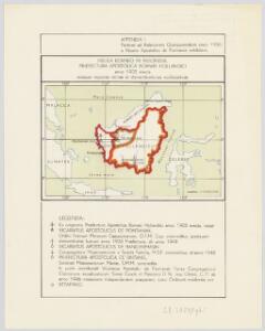
Insula Borneo in Indonesia : Præfectura Apostolica Bornæi Hollandici : anno 1905 erecta eiusque regiones vicinæ et dismembrationes ecclesiasticæ
1 : 16500000 titelvariant: Præfectura Apostolica Bornæi Hollandici [S.l. : Vicario Apostolico de Pontianak]
Borneo
Kaart van Nederlandsch Oost-Indië op een schaal van 1:1.800.000 / naar de nieuwste bronnen bew. onder toezicht van I. Dornseiffen door E. de Geest
1 : 1800000 Annotatie geografische gegevens: Inzet: De Natoena-eilanden; Noordelijk gedeelte der Tidoengsche landen; De Taloer- of Salibao-Eilanden; Atjih, Babi en Nias; Nieuw-Guinea (Nederlandsch gedeelte) en nabijliggende eilanden. - 1:6.000.000 Isaac Dornseiffen 1818-1898; Evert de Geest 1838-? Amsterdam : Seyffardt
Carte des îles Sumatra, Java et Bornéo et des mers environnantes
1 : 3770000 dressée par M. Daussy, d'après les travaux du Capitaine Horsburgh et d'autres navigateurs gravé par Chassant ; écrit par J.M. Hacq [...] [Paris] : Dépot-général de la Marine
Overzichtskaart van het Eiland Sumatra / Topographische Inrichting
Topographische Inrichting, Batavia Batavia : Topographische Inrichting
Insula Borneo et occidentalis pars Celebis cum adjacentibus Insulis. [Karte], in: Novus atlas absolutissimus, Bd. 9, S. 121.
1 Karte aus Atlas Janssonius Offizin
[Borneo, Celebes, Halmaheira, Ceram] / Top. Bureau v/d Gen. Staf
Topographisch Bureau Generale Staf Batavia Batavia : Top. Bureau v/d Gen. Staf
Blad XXI Boven Embaloeh (2) en Blad XXII Boven Kapoewas, uit: Residentie Wester-Afdeeling van Borneo / Topographisch Bureau
1 : 200000 titelvariant: Residentie Westerafdeeling van Borneo; Annotatie: Titelvariant: Residentie Westerafdeeling van Borneo; Voor aanwezige bladen zie overzichtsblad; Annotatie geografische gegevens: Opname: 1886-1895 Topographisch Bureau, Batavia Batavia : Topographisch Bureau
Borneo, Billiton en omliggende eilanden / ontworpen en geteekend door W.F. Versteeg
J.Voltelen Arnhem Arnhem : J. Voltelen
Reduzirte Karte vom Sunda- Oder Borneo-Meere und den Strassen zur Verbindung desselben mit dem Indischen und dem Chinesischen Meere, der Macassar-Strasse &c, zugleich als Karte von Djava, den kleinen Sunda-Inseln, Celebes, &c, &c.
1 : 2356000 dem .. Admiral Krusenstern [...] gewidmet von H. Berghaus gest. v. W. Jättnig Gotha : Perthes
Borneo / Army Map Service, Washington D.C.
Army Map Service Washington D.C. Washington D.C. : Army Map Service
Borneo / Topografische Dienst
Topografische Dienst Batavia Batavia : Reproductiebedrijf Topografische Dienst
Præfectura Apostolica de Bandjarmasin : anno 1938 i.e. anno dismembrationis a Vicariatu Apostolico Bornaei Hollandici ; Præfectura Apostolica de Sintang : anno 1948 i.e. anno dismembrationis a Vicariatu Apostolico de Pontianak
1 : 7500000 titelvariant: Præfectura Apostolica de Sintang; Annotatie: Stationes primariae cum anno erectionis [S.l. : Vicario Apostolico de Pontianak]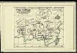
Süd-Borneo

Kaart van het eiland Borneo / Topographisch Bureau
Topographisch Bureau Batavia Batavia : Topographisch Bureau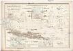
Reduzirte Karte vom SUNDA- ODER BORNEO-MEERE
1 : 2250000 Borneo Berghaus, Heinrich Karl Wilhelm Jättnig, Wilhelm J. Perthes
Overzichtskaart van het eiland Borneo : met aanduiding van de politieke indeeling, de organisatie van het bestuur, de bestaande en nog aan te leggen verkeerswegen en van de groote cultuur- en industrieele centra / samengesteld op last van de N.I. regeering [door de] Topographische Inrichting, Batavia
Topografische Inrichting Batavia Batavia : Topographische Inrichting
Concept oudheidkundige kaart van Borneo

Borneo / Geogr[aphische] lith[ographie] v[an] E. de Geest
Seyffardt's Boekhandel Amsterdam Amsterdam : Seyffardt's Boekhandel
Borneo
1 : 5000000 Annotatie: Linksonder: Molengraaff, Borneo; Proefdruk, bestemd voor, maar uiteindelijk niet opgenomen in: Geologische verkenningstochten in Centraal-Borneo (1893-94) / G.A.F. Molengraaff. - Leiden : Brill ; [etc.], 1900 [S.l. : s.n.] / (Leiden : Trap)
Borneo / Top[ographische] Inr[ichting]
Topographische Inrichting Batavia Batavia : Top[ographische] Inr[ichting]
Kalimantan
[S.l. : s.n.]
Kaart van het eiland Borneo
Grav. en druk van T. Hooiberg te Leiden te 's Hage : uitgave van K. Fuhri
Bladwijzer Zuider en ooster afd. van Borneo
[S.l. : s.n.]
Kaart van het eiland Celebes
D. Heyse lith. te 's Hage ; steendr. v. P. Blommers te 's Hage te 's Hage : uitgave van K. Fuhri
Algemeene schetskaart van Nederlandsch-Indië : Gouv[ernement] Groote Oost, Res[identie] Manado / Topografische Dienst, Batavia
[S.l. : s.n.]
Celebes, de Kleine Soenda-Eilanden / Geogr[aphische] lithogr[aphie] v[an] E. de Geest
Seyffardt's Boekhandel Amsterdam Amsterdam : Lith[ographische] Drukkerij van Seyffardt's Boekhandel te Amsterdam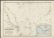
Reduzirte Karte vom Chinesischen Meere, 1.stes oder Südliches Blatt
1 : 2300000 H. Berghaus gestochen von W. Jaeck u. W. Brose Gotha : Perthes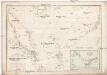
REDUZIRTE KARTE vom CHINESISCHEN MEERE
1 : 2350000 Asie jihovýchodní Berghaus, Heinrich Karl Wilhelm Brose, Wilhelm J. Perthes