Maps of Štôla

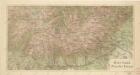
[Linkerblad], uit: Podrobná mapa Vysokých Tater
1 : 25000 Annotatie: Opname 1896/97, gedeeltelijk herzien 1931; Annotatie geografische gegevens: Inzet: Pérehled oblasti Tater. - 1:200.000 [Praag : Vojenský Zeméepisný Ústav]
[Gradkartenblatt]
1 : 25000 Slovensko Vojenský zeměpisný ústav
[Gradkartenblatt]
1 : 25000 Slovensko Vojenský zeměpisný ústav
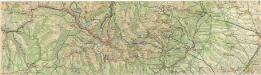
Orientačné mapy: Vysoké Tatry
Bělohlav, Josef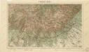
Vysoké Tatry
Podrobná mapa Vysokých Tater

Hohe Tatra
1 : 400000 Hohe Tatra
Vysoké Tatry

Vysoké Tatry

Vysoké Tatry

Píšova mapa Vysokých Tater
1 : 50000 Vysoké Tatry, pohoří-oblast (Polsko a Slovensko) Gregor, Julius A. Píša
Vysoké Tatry
1 : 40000 Vysoké Tatry, pohoří (Polsko a Slovensko) Mrázek, J. Klub čsl. turistů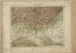
Vysoké Tatry

Vysoké Tatry
1 : 75000 Slovensko Vojenský zeměpisný ústav
VZÚ v Praze účastníkům I. sjezdu slovanských geografů v Praze 1924 -soubor map

III. vojenské mapování 4364
1 : 75000
Hohe Tátra
1 : 75000 Hohe Tatra, Spišská Sobota (Poprad) Geripp: Assist. Leitner. Terrain: Oberlt. Storch
Vysoké Tatry

Vysoké Tatry
1 : 75000 Vysoké Tatry, pohoří (Polsko a Slovensko) Čs. voj. zeměp. ústav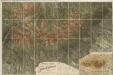
Detai - Karte des Tátra Gebietes
Hohe Tatra
Vysoké Tatry

[Gradkartenblatt]
1 : 25000 Slovensko Vojenský zeměpisný ústav
[Gradkartenblatt]
1 : 25000 Slovensko Vojenský zeměpisný ústav
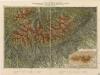
[Náčrt z Tater]
Tatry (Polsko a Slovensko : pohoří) Kořistka, Karel František Edvard
Vysoké Tatry
Terrain- und Höhenkarte der Hohen Tatra in den Central-Karpaten
1 : 100000 Vysoké Tatry, pohoří (Polsko a Slovensko) Kořistka, Karel František Edvard Petermann, August Justus Perthes
Terrain- und Höhenkarte der Hohen Tatra in den Central-Karpaten
1 : 100000 Vysoké Tatry, pohoří (Polsko a Slovensko) Kořistka, Karel František Edvard Petermann, August Justus Perthes
Hohe Tatra.
from Spezialkarte der osterreichisch-ungarischen Monarchie.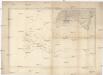
![[Linkerblad], uit: Podrobná mapa Vysokých Tater](https://images-2.georeferencer.com/images/iiif/050908191788/full/,300/0/native.jpg)

