Maps of Rhein-Erft-Kreis

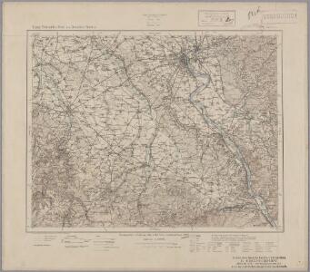
123. Cöln a. Rh., uit: Topographische Uebersichtskarte des Deutschen Reiches / herausgegeben v. d. Kartogr. Abt. d. Königl. Preuß. Landesaufnahme
1 : 200000 titelvariant: Topogr. Übersichtskarte des Deutschen Reiches; Annotatie: Titel boven bladen ook: Topogr. Übersichtskarte des Deutschen Reiches; Annotatie geografische gegevens: Op elk blad twee maatstokken: 10 Kilometer = 5,5 cm; 1 geogr. Meile = 3,6 cm; Legenda onder op elk blad Königlich Preußische Landesaufnahme. Kartographische Abtheilung [S.l : Königlich Preußische Landesaufnahme, Kartographische Abtheilung]
[20] Sect. Cöln, uit: Geologische Karte der Rheinprovinz und der Provinz Westphalen / ausgeführt durch H. von Dechen
1 : 80000 titelvariant: Dechen's geologische Karte vom Rheinland und Westphalen; Annotatie: Titel op bladoverzicht; Incompleet Heinrich von Dechen Berlin : Schropp
Descriptio agri civitatis Coloniensis : cum suis limitibus, terminis, viis, confiniis, interjacentibus, et adjacentibus pagis, villis, castris etc
1 : 60000 Cóvens et Mortier apud I. Cóvens et C. Mortier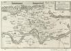
Accurata Territorii Coloniensis Descriptio
Mollova mapová sbírka Person, Nikolaus Person, Nicolas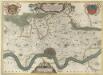
Descriptio Agri Civitatis Coloniensis
1 : 55000 Mollova mapová sbírka Blaeu, Joan Mortier, Pierre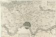
Descritione del distretto della Citta di Colonia con li suoi termini Confini, Villaggi, e Terre &
1 : 55000 Mollova mapová sbírka Hacque, Johann Baptist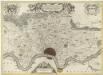
Descriptio Agri Civitatis Coloniensis
1 : 55000 Mollova mapová sbírka Blaeu, Joan Blaeu, Joan I.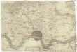
Descritione' del dis[tretto] della citta' di Colo[nia] con li suoi termi[ni] confini, villagi e terr[e &]
1 : 100000 Kolín nad Rýnem-oblast (Německo)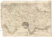
Descritione' del distretto della citta' di Colonia con li suoi termini confini, villagi e terre &
1 : 100000 Kolín nad Rýnem-oblast (Německo)
Colonia Agrippina antiquissima, maxima ac celeberrima Libera Imperii Civitas et Emporium florentissimum
1 : 12000 Mollova mapová sbírka Seutter, Matthäus Seutter, Matthäus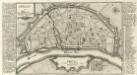
Cölln am Rhein.
1 : 18000 Mollova mapová sbírka Bodenehr, Gabriel Bodenehr, Gabriel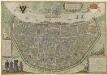
Colonia Agrippina
Mollova mapová sbírka Brachel, Peter von Hogenberg, Franz Braun, Georg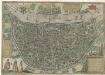
Colonia Agrippina
Mollova mapová sbírka Brachel, Peter von Hogenberg, Franz Braun, Georg
Colonia Agrippina
Mollova mapová sbírka Brachel, Peter von Hogenberg, Franz Braun, Georg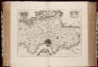
Descriptio agri civitatis Coloniensis : cum suis limitibus, terminis, viis, confiniis, interjacentibus et adjacentibus pagis, villis, castris, etc. / [Joan Blaeu]
1 : 25000 Annotatie: Het eerst verschenen in: Atlas maior, sive Cosmographia Blaviana ... - Amstelaedami : sumptibus Ioannis Blaeu, 1662; Origineel is Blad 72 in atlas factice; Annotatie geografische gegevens: West boven Blaeu, Joan [Amsterdam : Joan Blaeu]
DESCRIPTIO AGRI | CIVITATIS COLONIENSIS, | Cum suis limitibus, terminis, viis, confiniis, interjacen- | tibus et adjacentibus Pagis, Villis, Castris, etc.
[Amsterdam : Joan Blaeu]
Plan von Coeln u. Umgegend
1 : 25000 Roos Lengfeld
Orographische Karte des Siebengebirges bei Bonn
1 : 50000 hrsg. in der lith. Anst. v. Henry & Cohen Bonn : Henry & Cohen
Geognostischer Führer in das Siebengebirge am Rhein
1 : 25000 Dechen, Heinrich ; von Rath, G. vom Henry & Cohen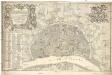
Nova et accurata ichnographia liberae ac imperialis civitatis Coloniensis anno 1752 confecta et ejusdem civitatis perillustribus strenuls consultis simisque dominis d[omi]nis consultibus et senatui
1 : 3800 Kolín nad Rýnem (Německo) Reinhardt, J. V. Rößler, Michael
Meßtischblatt 3156 : Linz, 1910
1 : 250000 Linz. - Aufn. 1893, hrsg. 1895, bericht. 1910. - 1:25000. - [Berlin]: Kgl. Preuss. Landesaufnahme, 1910. - 1 Kt.
Meßtischblatt 3156 : Ahrweiler, 1932
1 : 250000 Ahrweiler. - Hrsg. 1895, bericht. 1932. - 1:25000. - [Berlin]: Reichsamt für Landesaufnahme, 1932. - 1 Kt.
Meßtischblatt 3156 : Ahrweiler, 1926
1 : 250000 Ahrweiler. - Aufn. 1893, bericht. 1910, einz. Nachtr. 1926. - 1:25000. - [Berlin]: Reichsamt für Landesaufnahme, 1926. - 1 Kt.
Meßtischblatt 3156 : Ahrweiler, 1895
1 : 250000 Ahrweiler. - Aufn. 1893. - 1:25000. - [Berlin]: Kgl. Preuss. Landesaufnahme, 1895. - 1 Kt.
Meßtischblatt 3155 : Altenahr, 1895
1 : 250000 Altenahr. - Aufn. 1893. - 1:25000. - [Berlin]: Kgl. Preuss. Landesaufnahme, 1895. - 1 Kt.
Meßtischblatt 3154 : Münstereifel, 1895
1 : 250000 Münstereifel. - Aufn. 1893. - 1:25000. - [Berlin]: Kgl. Preuss. Landesaufnahme, 1895. - 1 Kt.
Meßtischblatt 3153 : Mechernich, 1895
1 : 250000 Mechernich. - Aufn. 1893. - 1:25000. - [Berlin]: Kgl. Preuss. Landesaufnahme, 1895. - 1 Kt.
Meßtischblatt 5404, Preuß 3152 alt : Schleiden, 1938
1 : 250000 Schleiden. - Aufn. 1892, bericht. 1938, vorläuf. Ausg., Nur für d. Dienstgebrauch!. - 1:25000. - [Berlin]: Reichsamt für Landesaufnahme, 1938. - 1 Kt.
Meßtischblatt 5309 : Honnef-Königswinter, 1948
1 : 250000 Honnef- Königswinter. - Aufn. 1893, hrsg. 1895, bericht. 1938, Ausg. 1942. - 1:25000. - Bad Godesberg : HVA, 19[48]. - 1 Kt.