Maps of Ardennes

Givet 97, uit: Special-Karte von Mittel-Europa / nach amtlichen Quellen bearbeitet von W. Liebenow
1 : 300000 titelvariant: W. Liebenow's Mittel-Europa; Annotatie: Titel boven de bladen: W. Liebenow's Mittel-Europa Johannes Wilhelm Liebenow 1822-1897 Frankfurt a. M. : Ludwig Ravenstein
Carte topographique d'Allemagne
1 : 224000 Bouillon (Belgie) Jaeger, Johann Wilhelm Abraham I.W.A. Iaeger
Carte topographique d'Allemagne
1 : 224000 Limburg (Belgie : provincie) Jaeger, Johann Wilhelm Abraham I. W. A. Iaeger
Carte topographique tres exacte
1 : 230000 Belgie W. D. S. Jaeger, Johann Christian I.C. Iaeger
Leodiensis Dioecesis Typvs
1 : 330000 Mollova mapová sbírka Ortelius, Abraham
Carte Contenant le Pais entre Namur, Liege, Meziere te Arlon
1 : 200000 Mollova mapová sbírka Le Rouge, Georges-Louis Le Rouge, Georges-Louis
Area Bella Gerentium in Gallia et Belgio :
1 : 585000 Mollova mapová sbírka Valk, Gerhard
Luxembourg.
1 : 275500 Robert de Vaugondy, Gilles, 1688-1766
Ducatus Luxemburg
1 : 316000 Mollova mapová sbírka Seutter, Matthäus Seutter, Matthäus Seutter, Matthäus
Ducatus Luxemburgi
1 : 316000 Mollova mapová sbírka Homann, Johann Baptist Homann, Johann Baptista
Givet 97, uit: [W. Liebenow's Special-Karte von Mittel-Europa]
1 : 300000 titelvariant: W. Liebenow's Mittel-Europa; Annotatie: Titel boven de bladen: W. Liebenow's Mittel-Europa Johannes Wilhelm Liebenow 1822-1897 Hannover : Hermann Oppermann
Le Duché de Luxembourg
1 : 330000 Mollova mapová sbírka Fer, Nicolas de Starckman, P. Fer, Nicolas de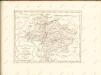

Le duché de Luxembourg
1 : 370000 Lucembursko Fer, Nicolas de Starckman, P. N. de Fer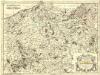
Paemani in Eburonibus
1 : 240000 Mollova mapová sbírka Sanson, Nicolas Mariette, Pierre
Comitatus Namurcensis cum Finitimis Regionibus, ad Usum Serenissimi Burgundiae Ducis
Mollova mapová sbírka Covens, Johannes Covens, Johannes I
Le Duché de Luxembourg divisé en Quartier Walon, et Allemand
1 : 140000 Mollova mapová sbírka Jaillot, Alexis-Hubert Jaillot, Alexis Hubert
Le Comté de Namur, Partie de l'Evesché de Liege, du Luxembourg, &c.
1 : 140000 Mollova mapová sbírka Jaillot, Alexis-Hubert Jaillot, Alexis Hubert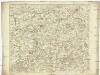
Le comté de Namur, partie de l'evesché de Liege, du Luxembourg, &c
1 : 130000 Lucembursko (Belgie) Jaillot, Alexis-Hubert Jaillot
Comté de Namur. Tiré des Memoires les plus nouueaux
1 : 158000 Mollova mapová sbírka Sanson, Guillaume Jaillot, Alexis Hubert
Carte de la Principauté de Liege et de la Comté de Namur
1 : 135000 Mollova mapová sbírka Maire, Christopher Kints, Everard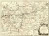
Le Comté de Namur
1 : 140000 Mollova mapová sbírka Nolin, Jean-Baptiste Nolin, Jean Baptiste II.
Carte particuliere des environs de Philippeville, Charlemont, Marienbourg, Rocroy, Charleville, Mezieres, Sedan
1 : 150000 sur la copie de Brussel par E.H. Fricx A Amsterdam : chez J. Covens et C. Mortier
XIX ; 4.L., uit: Carte chorographique des Pays-Bas Autrichiens / ... par le Comte de Ferraris ; gravée par L.A. Dupuis
1 : 86400 Annotatie: Bladen linksboven genummerd met Romeinse cijfers, rechtsboven met een cijfer en een letter; Met opdracht aan keizer Joseph II (bl.XVI); Met plattegrond van Brussel (bl. XXI), overzichtskaart (bl. XXII) en bladwijzer (bl. XXIII); Annotatie geografische gegevens: Schaalstokken: Echelle de Toises ou de Lieues communes de France; Echelle de Verges ou de Lieues de Brabant; Echelle de Milles d'Allemagne (bl. XVII); Echelle de Mètres; In de hoeken lengte- en breedtematen T.M.e en T.P.e Joseph-Jean François Ferraris Comte de 1726-1814; L.A. Dupuis [S.l. : s.n.]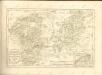

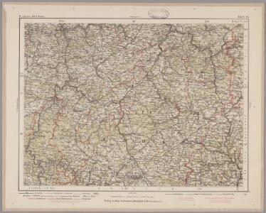
136. Malmedy, uit: Topographische Uebersichtskarte des Deutschen Reiches / herausgegeben v. d. Kartogr. Abt. d. Königl. Preuß. Landesaufnahme
1 : 200000 titelvariant: Topogr. Übersichtskarte des Deutschen Reiches; Annotatie: Titel boven bladen ook: Topogr. Übersichtskarte des Deutschen Reiches; Annotatie geografische gegevens: Op elk blad twee maatstokken: 10 Kilometer = 5,5 cm; 1 geogr. Meile = 3,6 cm; Legenda onder op elk blad Königlich Preußische Landesaufnahme. Kartographische Abtheilung [S.l : Königlich Preußische Landesaufnahme, Kartographische Abtheilung]
Namvrcvm Comitatvs
1 : 140000 Mollova mapová sbírka Surhon, Jean de Schenk, Peter I
NAMVRCVM | COMITATVS
Auctore Iohann. Surhonio. [Amsterdam : Joan Blaeu]