Maps of Bagrationovsky District

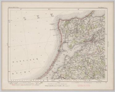
Köningsberg 17, uit: Special-Karte von Mittel-Europa / nach amtlichen Quellen bearbeitet von W. Liebenow
1 : 300000 titelvariant: W. Liebenow's Mittel-Europa; Annotatie: Titel boven de bladen: W. Liebenow's Mittel-Europa Johannes Wilhelm Liebenow 1822-1897 Frankfurt a. M. : Ludwig Ravenstein
[Kaliningrad a okolí]
1 : 760000 Kaliningrad-oblast (Rusko)
Sect. 6. Königsberg (West-Samland), uit: Geologische Karte der Provinz Preussen
1 : 100000 Annotatie: Incompleet; Voor aanwezige bladen zie bladoverzicht; Met inzetkaarten; Annotatie geografische gegevens: Coördinaten gebaseerd op nulmeridiaan van Ferro (Hierro) Berlin : Neumann
Sect. 14. Heiligenbeil, uit: Geologische Karte der Provinz Preussen
1 : 100000 Annotatie: Incompleet; Voor aanwezige bladen zie bladoverzicht; Met inzetkaarten; Annotatie geografische gegevens: Coördinaten gebaseerd op nulmeridiaan van Ferro (Hierro) Berlin : Neumann
72. Frauenburg. (48. Gr. Bruch) (Germany)
1 : 100000 Reichsamt fur Landesaufnahme
Composite: 48. Gr. Bruch. (72. Frauenburg) (Germany)
1 : 100000 Reichsamt fur Landesaufnahme
Composite: 72. Frauenburg. (48. Gr. Bruch) (Germany)
1 : 100000 Reichsamt fur Landesaufnahme
Composite: 28. Cumehnen. (Germany)
1 : 100000 Reichsamt fur Landesaufnahme
28. Cumehnen. (Germany)
1 : 100000 Reichsamt fur Landesaufnahme
Composite: 49. Pillau. (Germany)
1 : 100000 Reichsamt fur Landesaufnahme
49. Pillau. (Germany)
1 : 100000 Reichsamt fur Landesaufnahme
29. Cranz. (Germany)
1 : 100000 Reichsamt fur Landesaufnahme
48. Gr. Bruch. (72. Frauenburg) (Germany)
1 : 100000 Reichsamt fur Landesaufnahme
Composite: 50. Konigsberg i.Pr. (Germany)
1 : 100000 Reichsamt fur Landesaufnahme
Composite: 29. Cranz. (Germany)
1 : 100000 Reichsamt fur Landesaufnahme
50. Konigsberg i.Pr. (Germany)
1 : 100000 Reichsamt fur Landesaufnahme
71. Tiegenort. (Germany)
1 : 100000 Reichsamt fur Landesaufnahme
Königsberg und Umgegend
1 : 370000 Königsberg, Umland
15. Sarkau. (Germany)
1 : 100000 Reichsamt fur Landesaufnahme
Umgegend v. Königsberg
1 : 200000 Königsberg, Umland
Composite: 15. Sarkau. (Germany)
1 : 100000 Reichsamt fur Landesaufnahme
Meßtischblatt 1689 : Pr. Eylau, 1937
1 : 250000 Pr. Eylau. - Hrsg. 1912, bericht. 1928, einz. Nachtr. 1937. - 1:25000. - [Berlin]: Reichsamt für Landesaufnahme, 1937. - 1 Kt.
Meßtischblatt 1688 : Canditten, 1940
1 : 250000 Canditten. - Aufn. 1910, hrsg. 1912, bericht. 1928, letzte Na. - 1:25000. - [Berlin]: Reichsamt für Landesaufnahme, 1940. - 1 Kt.
Meßtischblatt 1686 : Eisenberg (i. Ostpr.), 1936
1 : 250000 Eisenberg (i. Ostpr.). - Hrsg. 1913, bericht. 1928. - 1:25000. - [Berlin]: Reichsamt für Landesaufnahme, 1936. - 1 Kt.
Meßtischblatt 399 : Braunsberg (Ost), 1937
1 : 250000 Braunsberg (Ost). - Hrsg. 1912, bericht. 1928, einz. Nachtr. 1937. - 1:25000. - [Berlin]: Reichsamt für Landesaufnahme, 1937. - 1 Kt.
Meßtischblatt 397, neue Nr. 1683 : Tolkemit, 1940
1 : 250000 Tolkemit. - Hrsg. 1911, einz. Nachtr. 1929, redakt. Änd. 194. - 1:25000. - [Berlin]: Reichsamt für Landesaufnahme, 1940. - 1 Kt.
Meßtischblatt 396, 331 a : Kahlberg- Liep, 1933
1 : 250000 Kahlberg- Liep. - Hrsg. 1911, Nachtr. 1925. - 1:25000. - [Berlin]: Reichsamt für Landesaufnahme, 1933. - 1 Kt.
Meßtischblatt 1680 : Steegen, 1936
1 : 250000 Steegen. - Hrsg. 1910, Nachtr. 1925. - 1:25000. - [Berlin]: Reichsamt für Landesaufnahme, 1936. - 1 Kt.
Meßtischblatt 1690 : Glommen, 1938
1 : 250000 Glommen. - Hrsg. 1913, bericht. 1928, einz. Nachtr. 1938. - 1:25000. - [Berlin]: Reichsamt für Landesaufnahme, 1938. - 1 Kt.