Maps of Kanal

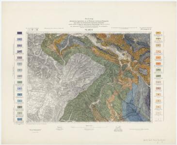
Zone 21, Kol. IX, Tolmein, uit: Geologische Karte der im Reichsrathe vertretenen Königreiche und Länder der Österreich-Ungarischen Monarchie : auf Grundlage der Specialkarte i.M. 1:75.000 des k.u.k. Militär-geographischen Institutes / neu bearb. und als Kartenwerk von 341 Blattnummern in zwanglosen Lfg. hrsg. durch die k.k. Geologische Reichsanstalt in Wien
1 : 75000 titelvariant: Geologische Spezialkarte der im Reichsrate vertretenen Königreiche und Länder der Österreichisch-Ungarischen Monarchie; Geologische Specialkarte der im Reichsrathe vertretenen Königreiche und Länder der Österreichisch-Ungarischen Monarchie; Annotatie: Titel bovenaan kaartblad: Geologische Spezialkarte der im Reichsrate vertretenen Königreiche und Länder der Österreichisch-Ungarischen Monarchie en Geologische Specialkarte der im Reichsrathe vertretenen Königreiche und Länder der Österreichisch-Ungarischen Monarchie; Annotatie geografische gegevens: Coördinaten gebaseerd op nulmeridiaan van Ferro (Hierro) Kaiserlich-Königliche Geologische Reichsanstalt, Wenen Wien : K.K. Geologische Reichsanstalt
Tolmein.
from Spezialkarte der osterreichisch-ungarischen Monarchie.
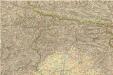
Uebersichtsblatt zum Kriegsspielplan der Umgebung von Gorz

Italy 1:100,000 / Sardinia 1:100,000, Tolmino
Italy 1:100,000 / Sardinia 1:100,000 , Series GSGS 4164. Great Britain. War Office. General Staff. Geographical Section. [London] : War Office
Bez titulu: Okolí Gorice

Nördliches Isonzogebiet
Isonzo-Gebiet Isonzoschlachten
[Gorice a Gradiška]
Gorice a Gradiška im Verl. des Geograph. Instituts
Comitatus Goritiae Et Finitima
1 : 115000 Mollova mapová sbírka Coronini, Rudolf Winkler, Johann Christoph
Trst
1 : 200000 Terst (Itálie) Kartografska radionica
Der Goerzer Kreis und der Triester Kreis
1 : 260000 Gorizia (Itálie) Kindermann, Joseph Karl Junker, Christoph Franz Xaver Miller
Comitatus Goritiae et Gradiscae
1 : 216000 Mollova mapová sbírka Coronini, Rudolf
Gründt Riß der Statt Görtz
Mollova mapová sbírka Merian, Matthaeus Merian, Caspar
Comitatus Goritiae et Gradiscae cum limitibus Venetis et vicinia
1 : 220000 Benátky (Itálie) Coronini, Rudolf Quischae, D.
Carta d ́Italia speciale per Automobilisti

Le Frioul
1 : 278000 Furlandsko Santini, P. Remondini, M. M. Remondini
Carta topografica della provincia del Friuli
1 : 162000 Furlandsko Malvolti, Giuseppe Zuliani, Pietro
Aus der Übersichtskarte von Mittel-Europa 1:750 000
1 : 750000 Evropa střední K. k. Österreichische Staatsbahnen
Carta delle contee di Gorizia, di Gradisca, distetto di Trieste, e del Friuli Veneto
1 : 208000 Burgenland (Rakousko) Capellaris, Giann Antonio Tommasini
Patria del | FRIVLI | olim | FORVM IVLII.
[Amsterdam : Joan Blaeu]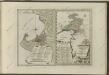

Patria del Friuli olim Forum Iulii [Karte], in: Novus Atlas, das ist, Weltbeschreibung, Bd. 3, S. 148.
1 Karte aus Atlas Blaeu, Joan Blaeu, Willem Janszoon
Patria del Friuli olim Forum Iulii [Karte], in: Theatrum orbis terrarum, sive, Atlas novus, Bd. 3, S. 128.
1 Karte aus Atlas Blaeu, Joan Blaeu, Willem Janszoon
Nuova carta topografica del territorio di Friul
1 : 210000 Furlandsko Capellaris, Gio. Antonio Furlanetto, Lodovico Lodovico Furlanetto
G. Freytags Karte der Isonzo-Front
1 : 350000 Gorizia (Itálie : provincie) Kartogr. Anstalt G. Freytag & Berndt
Carta Generale del Regno Lombardo-Veneto e paesi limitrofi... II.

Carta del Friuli tra i fiumi Livenza ed Isonzo
1 : 200000 Furlandsko Marinelli, Giovanni Taramelli, Torquato E. Passero
Il Friuli colla Carnia e Cadorino di nuova projezione
1 : 402000 Furlandsko Pitteri, Marco Alvise Antonio Zatta
Ducatus Carnioliae Tabula Chorographica Iusu Sumptuque inclytorum Provinciae Statuum.
1 : 100000 Mollova mapová sbírka Florjančič de Grienfeld, Janez Dizma