Maps of Sachsen-Anhalt

Sect. 14: Berlin, uit: Geologische Karte des Deutschen Reichs in 27 Blaettern / [von] Richard Lepsius ; Red. von C. Vogel
1 : 500000 Annotatie: Blad 18 ontbreekt; Een aantal bladen op linnen; Een aantal bladen gereviseerd 1913-1914; Annotatie geografische gegevens: Met schaalstokken o.a. in kilometers; Legenda Carl Vogel 1828-1897 Gotha : Justus Perthes
Saxoniae tractus Ducatum Magdeburgensem cum suo circulo Salico princ. Anhaltinum Halberstadiensem finitimarumq. regionum electoratus nempe Brandenburg. Saxoniae ducatus Brunsvicensis etc. partes ostendens
1 : 490000 Anhaltsko (Německo) Homann, Johann Christoph Homannovi dědicové
Saxoniae tractus ducatum Magdeburgensem cum suo circulo Salico princ. Anhaltinum Halberstadiensem finitimarumq. regionum electoratus nempe Brandenburg. Saxoniae ducatus Brunsvicensis etc. partes ostendens
1 : 490000 Anhaltsko (Německo) Homann, Johann Christoph Homannovi dědicové
Saxoniae Tractus Ducatum Magdeburgensem
1 : 370000 Mollova mapová sbírka Homann, Johann Baptist Homann, Johann Baptista
Geographische Charte des Hertzogthums und Halle Nebst etlichen angräntzende Orthen und Fürstenthume Gestochen
1 : 310000 Mollova mapová sbírka Schenk, Pieter Schenk, Peter II
Ducatus Magdeburgensis et Halensis cum finitimis Delineatio geographica curante
1 : 320000 Mollova mapová sbírka Seutter, Matthäus Lotter, Tobias Conrad Seutter, Matthäus
Das Hertzogthum Magdeburg mit seinen abgetheilten Provintzien
1 : 930000 Mollova mapová sbírka Weigel, Johann Christoph Weigel, Johann Christoph
Berlin - Leipzig - Wittenberge

Saxonia Superior [Karte], in: Novus atlas absolutissimus, Bd. 2, S. 66.
1 Karte aus Atlas Janssonius Offizin
Geographische Charte des Herzogthums Magdenburg und Halle
1 : 308000 Halle an der Saale-oblast (Německo) Schenk, Pieter P. Schenk
Geographische Charte des Herzogthums Magdenburg und Halle
1 : 308000 Halle an der Saale-oblast (Německo) Schenk, Pieter P. Schenk
Geographische Charte des Herzogthums Magdenburg und Halle
1 : 308000 Halle an der Saale-oblast (Německo) Schenk, Pieter P. Schenk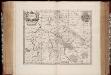
Saxonia svperior
1 : 350000 Annotatie: Origineel is Blad 98 in atlas factice; Annotatie geografische gegevens: Schaalvermelding op de kaart: 2 Milliaria Germanica communia; Rechtsboven binnen kader: XXI; De kaart toont Ober Sachsen met het bisdom Halle, het vorstendom Anhalt en het graafschap Barby Johannes Janssonius van Waesberge -1681?; Moses Pitt ca. 1654-1696; Stephanus Swart [Oxford : apud Janssonio-Waesbergios, Mosem Pitt et Stephanum Swart]
SAXONIA | SVPERIOR, & | HALL EPISCOPATVS.
Amstelædami J. Blaeu excudebat
Principatus Anhaldinus Et Magdeburgensis Archiepiscopatus. [Karte], in: Novus atlas absolutissimus, Bd. 2, S. 78.
1 Karte aus Atlas Janssonius Offizin
Saxonia Svperior.
1 : 350000 Mollova mapová sbírka Janssonius van Waesberge, Johannes Pitt, Moses
Saxonia Svperior & Hall Episcopatvs
1 : 300000 Mollova mapová sbírka Blaeu, Joan Blaeu, Joan I.
Regiae Celsitvdini Sereniss. Principi ac Dno. Frider. Christiano Leopoldo Princ. Pol. et Lith. Reg. Princ. Elect. ac Dvci Sax. Dno. Svo Longe Clementiss. Consistorii Wittebergensis Tabvlam Hanc Geographicam Svmma Mentis Pietate Consecravit Svbiectissimvs
1 : 250000 Mollova mapová sbírka Vierenklee, Johann Ehrenfried Homann, Johann Baptista - dědici
Magdebvrgensis Archiepiscopatvs
1 : 350000 Mollova mapová sbírka Blaeu, Joan Blaeu, Joan I.
MAGDEBVRGENSIS | ARCHIEPISCOPATVS.
Amstelædami | J. Blaeu excudebat.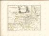

Straßen in den Anhaltischen Herzogtümern 1848
Anhalt Straßennetz Kunz, Andreas ; Treiling, Thomas
Regiae celsitvdini sereniss. principi ac domino Frieder. Christiano Leopoldo [...] consistorii Wittebergensis tabvlam hanc geographicam svmma mentis pietate consecravit
1 : 250000 Braniborsko (Německo) Vierenklee, Johann Ehrenfried Homannianos Heredes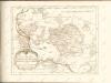

Anhaltinus Principatus Stirpis Ascaniensis felicitate hodiè florens
Seutter, Matthäus; Lotter, Tobias Conrad
Die Herzogthümer Anhalt Dessau, Cöthen u. Bernburg
1 : 780000 Anhaltsko (Německo) Bibliographisches Institut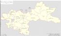
Regierungsbezirk Merseburg Kreiseinteilung 1820
Preußen, Merseburg, Regierungsbezirk Kunz, Andreas ; Johnen, Bettina ; Moeschl, Joachim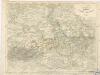
Die Herzogthümer Anhalt, Dessau, Cöthen u. Bernburg

Episcopatus Halberstadensis Descriptio nova. [Karte], in: Novus atlas absolutissimus, Bd. 2, S. 89.
1 Karte aus Atlas Janssonius Offizin
![Sect. 14: Berlin, uit: Geologische Karte des Deutschen Reichs in 27 Blaettern / [von] Richard Lepsius ; Red. von C. Vogel](https://images-2.georeferencer.com/images/iiif/320351585896/full/,300/0/native.jpg)

