Maps of Kreis Höxter

Sect. Warburg
1 : 80000 titelvariant: Warburg; Annotatie geografische gegevens: Legenda rechts van de kaart [Berlin : Simon Schropp'sche Hof-Landkartenhandlung]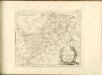

Plan de la Bataille de Wilhelmsthal
1 : 55000 Mollova mapová sbírka Bauer, Friedrich Wilhelm von Schley, Jacobus van der Gosse, Pierre II.
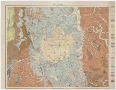
320. Furstenberg.
1 : 100000 Reichsamt fur Landesaufnahme
Messtischblatt 2588 : Warburg, 1933 Warburg
1 : 250000 Warburg. - Hrsg. 1909, einz. Nachtr. 1932, [gedr. 19]33. - 1:25000. - [Berlin]: Reichsamt für Landesaufnahme, 1933. - 1 Kt.
Meßtischblatt 2517 : Trendelburg, 1898
1 : 250000 Trendelburg. - Aufn. 1896. - 1:25000. - [Berlin]: Reichsamt für Landesaufnahme, 1898. - 1 Kt.
Meßtischblatt 2516 : Borgentreich, 1932
1 : 250000 Borgentreich. - Hrsg. 1898, bericht. 1907, einz. Nachtr. 1932. - 1:25000. - [Berlin]: Reichsamt für Landesaufnahme, 1932. - 1 Kt.
Meßtischblatt 2516 : Borgentreich, 1907
1 : 250000 Borgentreich. - Aufn. 1896, hrsg. 1898, bericht. 1907. - 1:25000. - [Berlin]: Reichsamt für Landesaufnahme, 1907. - 1 Kt.
Meßtischblatt Borgentreich
1 : 250000 Borgentreich. - Aufn. 1896. - 1:25000. - [Berlin]: Reichsamt für Landesaufnahme, 1898. - 1 Kt.
Meßtischblatt Peckelsheim
1 : 250000 Peckelsheim. - Aufn. 1896, bericht. 1937, gedr. 1945. - 1:25000. - [Berlin]: Reichsamt für Landesaufnahme, 1945. - 1 Kt.
Meßtischblatt 2444 : Karlshafen, 1937
1 : 250000 Karlshafen. - Hrsg. 1898, einz. Nachtr. 1937. - 1:25000. - [Berlin]: Reichsamt für Landesaufnahme, 1937. - 1 Kt.
Meßtischblatt 2444 : Karlshafen, 1898
1 : 250000 Karlshafen. - Aufn. 1896. - 1:25000. - [Berlin]: Reichsamt für Landesaufnahme, 1898. - 1 Kt.
Meßtischblatt 2443 : Borgholz, 1898
1 : 250000 Borgholz. - Aufn. 1896. - 1:25000. - [Berlin]: Reichsamt für Landesaufnahme, 1898. - 1 Kt.
Meßtischblatt 4320 : Willebadessen, 1945
1 : 250000 Willebadessen. - Stand 1937. - 1:25000. - [Berlin]: Reichsamt für Landesaufnahme, 1945. - 1 Kt.
Messtischblatt 2587 : Marsberg, 1909 Marsberg
1 : 250000 Marsberg. - Aufn. 1907. - 1:25000. - [Berlin]: Reichsamt für Landesaufnahme, 1909. - 1 Kt.
Meßtischblatt Kleinenberg
1 : 250000 Kleinenberg. - Aufn. 1896. - 1:25000. - [Berlin]: Reichsamt für Landesaufnahme, 1898. - 1 Kt.
Meßtischblatt 2441 : Lichtenau, 1898
1 : 250000 Lichtenau. - Aufn. 1896. - 1:25000. - [Berlin]: Reichsamt für Landesaufnahme, 1898. - 1 Kt.
Messtischblatt 2591 : Hann. Münden, 1926 Hann. Münden
1 : 250000 Hann. Münden. - Aufn. 1907, einz. Nachtr. 1926. - 1:25000. - [Berlin]: Reichsamt für Landesaufnahme, 1926. - 1 Kt.
Meßtischblatt 2518 : Ödelsheim, 1926
1 : 250000 Ödelsheim. - Aufn. 1896, einz. Nachtr. 1926. - 1:25000. - [Berlin]: Reichsamt für Landesaufnahme, 1926. - 1 Kt.
Meßtischblatt 2518 : Ödelsheim, 1898
1 : 250000 Ödelsheim. - Aufn. 1896. - 1:25000. - [Berlin]: Reichsamt für Landesaufnahme, 1898. - 1 Kt.
Meßtischblatt 2445 : Uslar, 1898
1 : 250000 Uslar. - Aufn. 1896. - 1:25000. - [Berlin]: Reichsamt für Landesaufnahme, 1898. - 1 Kt.
Paderbornensis Episcopatus Descriptio Nova [Karte], in: Le théâtre du monde, ou, Nouvel atlas contenant les chartes et descriptions de tous les païs de la terre, Bd. 1, S. 169.
1 Karte aus Atlas Blaeu, Willem Janszoon und Blaeu, Joan Blaeu, Willem Janszoon
Paderbornensis Episcopatus Descriptio Nova [Karte], in: Novus Atlas, das ist, Weltbeschreibung, Bd. 1, S. 138.
1 Karte aus Atlas Blaeu, Joan Blaeu, Willem Janszoon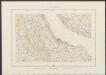
Paderbornensis Episcopatus, Descirptio Nova [Karte], in: Theatrum orbis terrarum, sive, Atlas novus, Bd. 1, S. 218.
1 Karte aus Atlas Blaeu, Joan Blaeu, Willem Janszoon
Episcopatus Paderbornensis descriptio nova [Karte], in: Novus atlas absolutissimus, Bd. 2, S. 124.
1 Karte aus Atlas Janssonius Offizin
Carte de l'Evêché de Paderborn
1 : 180000 Mollova mapová sbírka Carlet, Louis-François Lotter, Tobias Conrad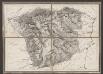
Episcopatus Paderbornensis descriptio nova [Karte], in: Gerardi Mercatoris et I. Hondii Newer Atlas, oder, Grosses Weltbuch, Bd. 1, S. 167.
1 Karte aus Atlas Mercator, Gerhard und Hondius, Jodocus Jansson, Jan
Episcopatus Paderbornensis descriptio nova / Iohanne Gigante Ludense ; [Henricus Hondius]
1 : 225000 Annotatie: Het eerst verschenen in: Novus Atlas ... Ersten Theils, Ander Stück. - Amstelodami : apud Ioannem Ianssonium, 1644; 1e staat: Amstelodami : Henricus Hondius, [1630]; Origineel is Blad 75 in atlas factice Gigas, Joannes (1580-1650); Hondius, Henricus Amstelodami : Joannes Janssonius excudit