Maps of Myanmar
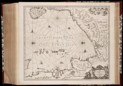
Sinus Gangeticus; vulgo Golfo de Bengala nova descriptio
1 : 4500000 Annotatie: Zeekaart; Kaart uitg. in de periode vanaf ca. 1650 tot ca. 1680; Origineel is Blad 190 in atlas factice; Annotatie geografische gegevens: Schaalstokken op de kaart: 45 Milliaria Germanica communia (=7,5 cm), en: 60 Milliaria Gallica communia (=7,5 cm); Westen boven Johannes Janssonius 1588-1664 [Amstelodami] : [Apud Ioannem Ianssonium]
Sinus Gangeticus: Vulgo Golfo De Bengala Nova descriptio. [Karte], in: Novus atlas absolutissimus, Bd. 9, S. 115.
1 Karte aus Atlas Janssonius Offizin
Sinus Gangeticus; Vulgo Golfo De Bengala Nova descriptio. [Karte], in: Het vijfde Deel Des Grooten Atlas : Vervatende De Water-Weereld, S. 92.
1 Karte aus Atlas Jansson, Jan Jansson, Jan
Bay of Bengal
Indian Ocean. Bay of Bengal. Compiled from the latest Government Surveys, 1880. London : Admiralty
India S.
1 : 4457000 Johnston, Alexander Keith, 1804-1871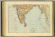
India South.
1 : 5448960 Stanford, Edward
Composite: l'Inde.
1 : 3100000 Anville, Jean Baptiste Bourguignon d, 1697-1782
Tabula Asiae XI. [Karte], in: Claud. Ptolemaeus. Geographia lat. cum mappis [...], S. 326.
1 Karte aus Atlas Münster, Sebastian [und Ptolemaeus, Claudius]
Indien & Inner-Asien In 2 Blattern. (Sudliches Blatt)
1 : 7500000 Petermann, A.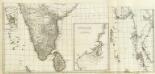
(Carte de l'Inde. Southern section).
1 : 3100000 Anville, Jean Baptiste Bourguignon d, 1697-1782
Inner-Asien & Indien, Südliches Blatt
Adolf Stieler's Handatlas über alle Theile der Erde und über das Weltgebäude Stieler, Adolf Justus Perthes
[Indien & Inner-Asien, Südliches Blatt]
Handatlas über alle Theile der Erde und über das Weltgebäude Stieler, Adolf Justus Perthes
Tabula Asiae XI. [Karte], in: Geographia universalis vetus et nova complectens Claudii Ptolemaei Alexandrini enarrationis libros VIII, S. 296.
1 Karte aus Atlas Münster, Sebastian [und Ptolemaeus, Claudius]

地圖綜要 : 三卷(西南海夷圖)
地圖綜要 南明弘光元年(1645),吴学俨等编纂,李釜源鉴定,朗润堂藏板。 该书为明末军事防务地图集,涉及诸多江防、海防、边防等相关地图和解说,军事意味明显,这与成书背景有密切关系。该书在江南刊刻成书之际,清军已大举入关,大明王朝覆灭,仅剩南明小王朝残喘于南方,军事防务至关重要。也因其明显的南明立场,该书被列为四库禁毁书。全书分总卷、内卷和外卷三部分。燕京藏本共八册,书前序言、凡例和目录的总卷部分缺失。 总卷论及大明疆域沿革、军事防守要害、各省道里等内容,地图有《華夷古今形勝圖》,未画方,标绘各府所在,在空白处标注史地简介;《天下各鎮各邊要圖》,未画方,标注北方边防各山口关隘、东南海防、西南边防等;《京省合宿分界圖》,未画方,图上方标注各星宿,对应大明各府州;《天下輿地分里總圖》,计里画方,每方五百里,绘制两京十三省各府所在地。 内卷为两京十三省的建置总数、分里图、分界图、各府州县志、总论及事宜,其中,建制总数包括府州县卫所及各类机构数量、户数、口数、税、钞、丝、绢、盐、马草等数量;分里图采用计里画方,分别绘制两京十三省各府、州、县、卫所及山川河流名;分界图则以突出府界和州县的相对位置,并不追求里程的准确性,因此,与分里图相比,不仅删去了山川地名和解说,而且地图变形较大,以便于较为疏朗地标注各府州县地名;各府州县志则包括省内各府的山川河流、土产古迹、名宦人物等通常为方志所记载的内容;总论高度概括各地历史和地理形势;事宜则多论及该地的军事守备要领。每省分里图和分界图各一幅。 外卷主要为江防、海防、边防相关地图和图说。包括《長江會源分里全圖》《江防全圖》《漕河分里圖》《黃河分里圖》《海防全圖》《日本島夷入寇要害圖》《海運分里圖》《九邊總圖》及九边分图《遼東沿邊圖》《薊鎮沿邊圖》《宣府沿邊圖》《大同沿邊圖》《山西沿邊圖》《大同山西二邊分里合圖》《延綏沿邊圖》《寧夏沿邊圖》《固原沿邊圖》《甘肅沿邊圖》《四夷總圖》及四夷分图《東北諸夷圖》《朝鮮圖》《日本圖》《琉球圖》《東南海夷圖》《東南濱海諸夷圖》《西南海夷圖》《安南圖》《迤北西番諸夷圖》《西域圖》《朔漠圖》等。 在外卷诸图中,以《江防全圖》规模最大、绘制最为详细,并附有详细的解说,显然,这与当时南明小王朝偏居南方的局势密切相关,天堑长江实际上已经成为南明小王朝最后的屏障。 在图例上,府用正方形,州用菱形(包括土州),县用椭圆,卫所用椭圆外加四方短线,但图上大多数卫所并没有标志。 李釜源名茹春,崇祯十年(1637 年)进士,知华亭县。 《中國古籍善本書目》著录。 8册64图,墨刻本,中文,尺寸24.7 x 16.3 cm,计里画方。 Harvard-Yenching | Rare Book | T 3080.7 2925,Harvard-Yenching | Microfilm | FC9113, Master Microforms | Offsite Storage | Film Mas 34483;Hollis Number:008094513 吴学俨等 朗润堂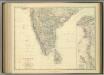
India (southern sheet).
1 : 4457000 Johnston, Alexander Keith
[Undecima Asie tabula] [Karte], in: Clavdii Ptholomei Viri Alexandrini Cosmographie, S. 188.
1 Karte aus Atlas Nicolaus Germanus [und Ptolemaeus, Claudius]
Undecima Asie Tabula [Karte], in: [Clavdii Ptholomei Cosmographi ...], S. 332.
1 Karte aus Atlas Nicolaus Germanus [und Ptolemaeus, Claudius]
140-141. South India, Ceylon, Burma. The World Atlas.
1 : 5000000 USSR (Union of Soviet Socialist Republics).
Inde Medionale.
1 : 5000000 Vivien St Martin, L.
Burmah
1 : 9000000 Annin & Smith Lincoln & Edmands
Birman Empire.
1 : 3700000 Thomson, John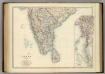
India (southern sheet).
1 : 4457000 Johnston, Alexander Keith
Burma und Malayische Halbinsel
1 : 6000000 Malajsie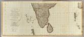
Hindoostan (south)
1 : 2500000 Robert Laurie & James Whittle
Peninsula Indiae citra Gangem hoc est orae celeberrimae Malabar & Coromandel cum adjacente insula non minus celebratissima Ceylon
1 : 3000000 Indie studio Homannianorum Heredum
Peninsula INDIAE citra Gangem, hoc est Orae celeberrimae MALABAR & COROMANDEL Cum adjacente Insula non minus celebratissima CEYLON
1 : 3000000 Ganga-oblast (Indie a Bangladéš) Delisle, Guillaume studio Homannianorum Heredum
Peninsula INDIAE citra Gangem hoc est Orae celeberrimae MALABAR & COROMANDEL Cum adjacente Insula non minus celebratissima CEYLON
1 : 3000000 Ganga-oblast (Indie a Bangladéš) Delisle, Guillaume studio Homannianorum Heredum
Indochine.
1 : 5000000 Vivien St Martin, L.