Maps of Israel
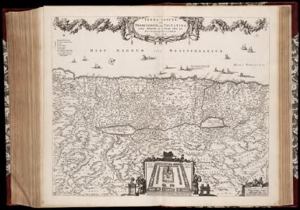
Terra Sancta, sive Promissionis, olim Palestina / recens delineata, et in lucem edita per Nicolaum Visscher anno 1659
1 : 900000 Annotatie: Dit exemplaar bevat bij enige plaatsnamen aan de westkust aantekeningen in pen; Origineel is Blad 183 in atlas factice; Annotatie geografische gegevens: Schaalstokken op kaart: 6 Milliaria Germanica communia = 6 Gemeene Duytsche Mylen van 15 in een Graed (=4,8 cm), en: 8 Milliaria unius Horæ = 8 Uren gaens yder synde 24 Stadien dat is 3000 passé (=4,8 cm); Noordwest boven; Inzet: Castrorum populi Israelitici Nicolaes Jansz Visscher sr 1618-1679 [S.l. : C.J. Visscher excudit]
Tabula Moderna Terre Sancte [Karte], in: [Clavdii Ptholomei Cosmographi ...], S. 311.
1 Karte aus Atlas Nicolaus Germanus [und Ptolemaeus, Claudius]
Iudaea seu terra sancta
1 : 600000 Izrael Sanson, Guillaume Cordier, Louis apud Hubertum Iaillot
Palestina nynější
Tabula Moderna Terre Sancte [Karte], in: Claudii Ptolemei viri Alexandrini mathematice discipline philosophi doctissimi geographie opus [...], S. 272.
1 Karte aus Atlas Waldseemüller, Martin [und Ptolemaeus, Claudius] Übelin, Georg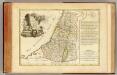
Douze Tribus d'Israel.
1 : 1030000 Bonne, Rigobert, 1727-1794
Iudaea seu Terra Sancta quae Hebraeorum sive Israelitarum in suas duodecim tribus divisa, secretis ab invicem regnis Iuda et Israel expressis insuper sex ultimi temporis ejusdem terrae provinciis
1 : 615000 Izrael Sanson, Guillaume Mortier, Pieter apud Petrum Mortier
Iudaea, seu Terra Sancta quae hebraeorum sive Israelitarum in suas duodecim tribus divisa, secretis ab invicem regnis Iuda, et Israel expressis insuper sex ultimi temporis ejusdem terrae provinciis
1 : 600000 Izrael Sanson, Guillaume Schenk, Pieter Pierre Schenk
Iudaea, seu Terra Sancta quae Hebraeorum sive Israelitarum in suas duodecim tribus divisa, secretis ab invicem regnis Iuda, et Israel expressis insuper sex ultimi temporis ejusdem terrae provinciis
1 : 600000 Izrael Sanson, Guillaume Schenk, Pieter Pierre Schenk
Karte von Palaestina
1 : 384000 Palestina Emmerich, Anna Katharina Riess, Richard Friedrich Pustet
Palestine
1 : 762000 Jeruzalém Hughes, W. Chapman & Hall
Karte von Palaestina
1 : 1030000 Jeruzalém Klöden, Karl Friedrich von Mare, Carl bei August Rücker
Palästina
Volksschul-Atlas über alle Teile der Erde Lange, Henry Druck und Verlag von Georg Westermann
Palestina za doby soudců a králů

Karte von Palästina
1 : 515000 Jeruzalém Velde, Charles William Meredith van de Justus Perthes
Palaestina.
1 : 1400000 Anville, Jean Baptiste Bourguignon d, 1697-1782
Palestine & Adjacent Countries.
1 : 1160000 Mitchell, Samuel Augustus
Palestine & Adjacent Countries.
1 : 1160000 Mitchell, Samuel Augustus
Palestine.
1 : 1650000 Monin, C.V.
Kaart van 't land Kanaan / naar de beste waarnemingen tot verstand van Num. XXI:14-31 ontworpen door R. Schutte ; J. van Jagen sculps. 1766
1 : 800000 Annotatie: Waarschijnlijk blad uit zakatlas Schutte, Rutger; Jagen, J. van Te Amsterdam : by J. Loveringh
La Palestine.
1 : 835000 Anville, Jean Baptiste Bourguignon d, 1697-1782
The Madaba Map
Jeruzalém Survey of Israel

Palaestina za času Krista Pána
1 : 1030000 Izrael Fáborský, Jan B. Dědictví sv. Cyrilla a Methodia
Palaestina za času Krista Pána
1 : 1030000 Izrael Fáborský, Jan B. Dědictví sv. Cyrilla a Methodia
Palestine.
1 : 684288 Stanford, Edward
TERRA SANCTA, SIVE PROMISSIONIS, olim PALESTINA
1 : 970000 Palestina Visscher, Nicolaus Visscher, Claes Jansz. C.I. Visscher excudit
Terra Sancta sive Promissionis, olim Palestina
1 : 970000 Palestina Visscher, Nicolaus per Nicolaum Visscher
Turkey in Asia (Biblical Regions) The Holy Land And Its Borders.
1 : 696960 Fullarton, A. & Co.