Maps of Cologne Government Region

Juliacensis ducatus / [Joannes Janssonius]
1 : 250000 Annotatie: Rechtsboven: XLV; Verschenen in: The English atlas volume III ... - Amsterdam : J. Jansonius a Waesberg and S. Swart, 1683; Origineel is Blad 68 in atlas factice; Oorspr. uitg.: [Amsterdam : Joannes Janssonius, 1636]; Annotatie geografische gegevens: Noordoost boven Janssonius, Joannes (jr.) (1588-1664) [Amsterdam : J. Jansonius van Waesberge etc.]
Iuliacensis Ducatus. [Karte], in: Gerardi Mercatoris et I. Hondii Newer Atlas, oder, Grosses Weltbuch, Bd. 1, S. 182.
1 Karte aus Atlas Mercator, Gerhard und Hondius, Jodocus Jansson, Jan
Archiepiscopatus et electoratus coloniensis ducatuum Iuliacensis montensis Limburgensis comitatus Meursiae et Geldriae Hispanicae
1 : 330000 Belgie Danckerts, Justus I. Danckerts
Archiepiscopatus et Electoratus Coloniensis, Ducatuum Iuliacensis Montensis Limburgensis Comitatus Meursiae et Geldriae Hispanicae, Novissima Descriptio
1 : 320000 Mollova mapová sbírka Danckerts, Justus Danckerts, Justus
Archiepiscopatus et electoratus Coloniensis, ducatuum Iuliacensis, Montensis Limburgensis comitatus Meursiae et Geldriae hispanicae, novissima descriptio
1 : 300000 1 Karte : Kupferdruck ; 47 x 56 cm Danckerts, Justus [Danckerts]
[Severní Porýní-Vestfálsko]
Severní Porýní-Vestfálsko (Německo)
Ducatus Juliaci & Bergensis tabula geographica, simul Ducatum Cliviae & Meursiae Principatum, nec non adjacterrarum inter quas integer Ducat. Limburgensis exhibetur fines complectens
1 : 315000 ex prototypo Jaillotiano delineata novisq accessionibus auctior & emendatior reddita [Norimbergae] : exeudentibus Homanianis Heredibus


Ducatus Iuliaci & Bergensis tabula geographica, simul ducatum Clivie & Meursiae principatum
1 : 350000 Jülich (Německo) Jaillot, Alexis-Hubert excudentibus Homannianis Heredibus
Ducatus Iuliaci & Bergensis tabula geographica, simul ducatum Clivie & Meursiae principatum
1 : 350000 Jülich (Německo) Jaillot, Alexis-Hubert excudentibus Homannianis Heredibus
Ducatus Iuliaci & Bergensis tabula geographica, simul ducatum Clivie & Meursiae principatum
1 : 350000 Jülich (Německo) Jaillot, Alexis-Hubert excudentibus Homannianis Heredibus
Ducatus Iuliaci & Bergensis tabula geographica, simul ducatum Clivie & Meursiae principatum
1 : 350000 Jülich (Německo) Jaillot, Alexis-Hubert excudentibus Homannianis Heredibus
Ducatus Iuliaci & Bergensis tabula geographica, simul ducatum Clivie & Meursiae principatum
1 : 350000 Jülich (Německo) Jaillot, Alexis-Hubert excudentibus Homannianis Heredibus
Ducatus Iuliaci & Bergensis tabula geographica, simul ducatum Clivie & Meursiae principatum
1 : 350000 Jülich (Německo) Jaillot, Alexis-Hubert excudentibus Homannianis Heredibus
Ducatus Iuliaci & Bergensis tabula geographica, simul ducatum Cliviae & Meursiae principatum nec non adj[...] terrarum inter quas integer ducat. Limburgensis exhibetur fines complectens
1 : 336300 Severní Porýní-Vestfálsko (Německo) Jaillot, Alexis-Hubert Homan[n]ianis Heredibus
Mappa Geographica, continens Archiepiscopatum et Electoratum Coloniensem
1 : 300000 Mollova mapová sbírka Seutter, Matthäus Seutter, Matthäus
Archiepiscopatus et Electoratus Coloniensis ut et Ducatuum Iuliacensis Et Montensis nec non Comitatus Meursiae Nova Tabula excudente
1 : 320000 Mollova mapová sbírka Homann, Johann Baptist Homann, Johann Baptista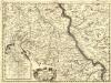
Parte Meridionale degli Stati dell'Elet. di Colonia
1 : 175000 Mollova mapová sbírka Coronelli, Vincenzo Maria
Mappa geographica, continens archiepiscopatum et electoratum Coloniensem
1 : 300000 Kolín nad Rýnem-oblast (Německo) Lotter, Tobias Conrad Tob. Conrad Lotter
Mappa geographica, continens archiepiscopatum et electoratum Coloniensem
1 : 300000 Kolín nad Rýnem-oblast (Německo) Seutter, Matthäus cura et sumtibus Matth. Seutteri
Archiepiscopatus Coloniensis Ducatibus Iuliacensi et Montensi Intermedius
1 : 300000 Mollova mapová sbírka Valk, Gerhard Valck, Gerard
Mappa geographica, continens archiepiscopatum et electoratum Coloniensem, cum conterminis ducatibus Juliacensi et Montensi, nec non comitatu Mursano
1 : 280000 Aug. Vind : cura et sumtibus Tob. Conrad Lotter
Le Duché de Juliers, l'Abbaye de St. Cornelis Mu[n]ster, la Baronie de Wickrad, et la ville imperiale d'Aix la Chapelle / tiré des memois les plus nouveaux par le Sr. Sanson
1 : 250000 Annotatie: Origineel is Blad 69 in atlas factice Guillaume Sanson 1633-1703 A Paris : chez H. Jaillot
Mappa geographica, continens archiepiscopatum et electoratum Coloniensem, cum conterminis ducatibus Juliacensi et Montensi, nec non comitatu Mursano
1 : 280000 Aug. Vind : cura et sumtibus Tob. Conrad Lotter
[57][57] Novissima et accuratissima Archiepiscopatus Coloniensis ..., uit: Atlas sive Descriptio terrarum orbis
Annotatie: Gedigitaliseerde versie. Amsterdam. Heiloo : Picturae (vervaardiger), 2015. tiff-bestand. Gedigitaliseerd: 07-01-2015; Origineel: Universiteitsbibliotheek Vrije Universiteit (XL.05127.-) ; Netherlands; Titelpagina ontbreekt Wit, Frederik de Amsterdam : Frederick de Wit
Le Duché De Iuliers, L'Abbaye De St. Cornelis Munster, La Baronie De Wickrad, et la Ville Imperiale D'Aix La Chapelle. [Karte], in: Atlas nouveau, contenant toutes les parties du monde [...], Bd. 1, S. 218.
1 Karte aus Atlas Sanson, Nicolas Jaillot, Alexis Hubert und Mortier, Pieter
Ducatus Iuliaci & Bergensis Tabula Geographica
1 : 340000 Mollova mapová sbírka Homann, Johann Baptist Homann, Johann Baptista - dědici

![Juliacensis ducatus / [Joannes Janssonius]](https://images-0.georeferencer.com/images/iiif/618861943543/full/,300/0/native.jpg)

