Maps of Grand Est
Exactissima Lotharingia : tam regis Gallorum quam Ducis Caroli / operâ Caroli Allard
1 : 450000 titelvariant: Exactissima Lotharingia tam regis Gallorum quam Ducis Caroli; Annotatie: Cum privil. ordinum Hollandiae et Westfrisiae; Origineel is Blad 21 in atlas factice; Oorspr. verschenen in: Atlas minor sive tabulae geographicae ... - Amstelodami : apud Carolum Allard, 1697; Annotatie geografische gegevens: Oost boven; Met 2 schaalstokken Carel Allard 1648-1709 Amsterdam : gedruckt by Carel Allardt
Gouvernement de Lorraine et celui d'Alsace
1 : 5920000 Alsasko (Francie) Bonne, Rigobert André
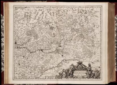
Generalis Lotharingiae ducatus tabula, qua accuratissimé ostenduntur ducatus Lotharingiae propriae et Barrensis, nec non Metensis, Tullensis, Verdunensis et alii tractus inserti et finitimi, et in quas minores ditiones subjacentes eorundem quisque divisus
1 : 500000 per Nicolaum Visscher Amst. Bat. Amst. Bat. : per Nicolaum Visscher
Generalis Lotharingiæ ducatus tabula
1 Karte auf 2 Blättern : Kupferdruck ; 61 x 55 cm Visscher N. Visscher
Metz-Belfort
1 : 300000 Kartogr. Abteilung der Kgl. Preuß. Landesaufnahme
Circvli Rheni Svperioris Pars meridionalis, seu superior Scissa, lacerata, dismembrata
1 : 1900000 Mollova mapová sbírka Franz, Johann Michael Homann, Johann Baptista - dědici
Mappa geographica, in qua ducatus Lotharingiae et Barr ut et episcopatuum Metens. Tullens. Verdunens. territoria, tractusque finitimi, in suos quiq. ditiones disterminati
1 : 499000 Bar-le-Duc (Francie) Lotter, Tobias Conrad Tob Conrad Lotter
Mappa geographica, in qua ducatus Lotharingiae et Barr ut et episcopatuum Metens. Tullens. Verdunens. territoria, tractusque finitimi, in suos quiq. ditiones disterminati
1 : 499000 Bar-le-Duc (Francie) Lotter, Tobias Conrad Tob Conrad Lotter
Mappa geographica, in qua ducatus Lotharingiae et Barr ut et episcopatuum Metens. Tullens. Verdunens. territoria, tractusque finitimi, in suos quiq. ditiones disterminati
1 : 499000 Bar-le-Duc (Francie) Lotter, Tobias Conrad Tob Conrad Lotter
Des Ober-Rheinischen Creißes Südlicher theil mit der Franche Comte und den ganzen Hertzogthum Lotharingen
1 : 26000 Mollova mapová sbírka Weigel, Christoph Weigel, Christoph I.
Mappa geographica, in qua ducatus Lotharingiæ et Barr ut et episcopatuum Metens. Tullens. Verdunens. territoria
1 Karte : Kupferdruck ; 48 x 57 cm Lotter Tobias Konrad Lotter
Mappa geographica, in qua ducatus Lotharingiæ et Barr ut et episcopatuum Metens. Tullens. Verdunens. territoria
1 Karte : Kupferdruck ; 49 x 56 cm Seutter Matthäus Seutter
Lotharingie Ducatus [Karte], in: Claudii Ptolemei viri Alexandrini mathematice discipline philosophi doctissimi geographie opus [...], S. 283.
1 Karte aus Atlas Waldseemüller, Martin [und Ptolemaeus, Claudius] Übelin, Georg
Lorraine, Alsace.
1 : 930000 Bonne, Rigobert, 1727-1794
Lotharingiae tabula generalis in qua ducatus Lotharingiae et Barri nec non Metensis, Tullensis et Verdunenis episcopatus cum insertis et finimitis ditionibus
1 : 500000 Lotrinsko (Francie) Homann, Johann Baptist a Ioh. Bapt. Homanno
LOTHARINGIAE TABULA GENERALIS
1 : 500000 Lotrinsko (Francie) Homann, Johann Baptist a Ioh. Bapt. Homanno
Lotharingiae tabula generalis
1 : 500000 Lotrinsko (Francie) Homann, Johann Baptist J. B. Homann
Lotharingiae tabula generalis in qua ducatus Lotharingiae et Barri nec non Metensis, Tullensis et Verdunenis episcopatus cum insertis et finimitis ditionibus
1 : 500000 Bar-le-Duc (Francie) Homann, Johann Baptist a Ioh. Bapt. Homanno
Lotharingae tabula generalis
1 : 500000 Lotrinsko (Francie) Homann, Johann Baptist a Ioh. Bapt. Hommano
Charte von Lothringen und Barr nebst den drey Bisthümern Metz, Toul und Verdun
1 Karte : Kupferdruck ; 45 x 56 cm Güssefeld bey den Homann. Erben
Mappa Geographica, in qua Ducatus Lotharingiae et Barr ut et Episcopatuum Metens. Tullens. Verdunens. Territoria, Tractusque Finitismi in suos quiq; ditiones disterminati sistuntur
1 : 500000 Mollova mapová sbírka Seutter, Matthäus Seutter, Matthäus

Lotharingiae Tabula Generalis
1 : 500000 Mollova mapová sbírka Homann, Johann Baptist Homann, Johann Baptista
La Lorraine qui comprend les duches de Lorraine et de Bar et de balliages des evesches et de villes de Metz, Toul et Verdun
1 Karte : Kupferdruck ; 43 x 47 cm verlegt bey Adam Ionathan Felseckern seel Erben
Les Duchez de Lorraine et de Bar.
1 : 450000 Mollova mapová sbírka Nolin, Jean-Baptiste Nolin, Jean-Baptiste I.
Lotharingia cum contiguis
1 : 860000 Mollova mapová sbírka Weigel, Christoph Weigel, Christoph I.
Charte von Lothringen und Barr nebst den drey Bisthümern Metz, Toul und Verdun
1 : 505000 Lotrinsko (Francie) Güssefeld, Franz L. bey den Homann. Erben
Les duchez de Lorraine et de Bar
1 Karte : Kupferdruck ; 46 x 60 cm Nolin; Du Tralage chez I. B. Nolin sur le quay de l'Horloge du Palais à l'enseigne de la place des Victoires vers le Pont Neuf
La Lorraine qui comprend les duchés de Lorraine et de Bar et les balliages des eveschés et des villes de Metz, Toul, et Verdun
1 Karte : Kupferdruck ; 45 x 60 cm Jaillot chez J. Cóvens et C. Mortier