Maps of Soudron
Chalons / réd. et gravée au Dépôt général de la Guerre sous la dir. de Pelet
1 : 80000 Jean Jacques Germain Pelet 1777-1858; Dépôt de la Guerre [Paris : Dépôt de la Guerre]
Plan‘‘sraženija pri Fer’’-Šampenuazě, 13 marta 1814 g.
Frankreich Fère-Champenoise Befreiungskriege <1813-1815>
Rhemi
1 Karte : Kupferdruck ; 34 x 54 cm Sanson; Robert de Vaugondy chés le S. Robert geog. ord. du roy quai de l'Horloge du Palais
Catalauni
1 Karte : Kupferdruck ; 41 x 51 cm Sanson; Robert de Vaugondy chés le S. Robert geog. du roy quai de l'Horloge
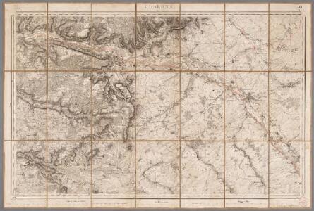
[Châlons-sur-Marne]
1 Blatt : 60 x 91 cm s.n.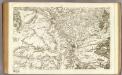
80 Chalons-en-Champagne.
1 : 86400 Cassini family; Cassini, Cesar-Francois, 1714-1784
Karta dlja ob‘‘jasnenija sraženiji pri Šampoberě, Monmiralě i Vošaně s‘‘ 29. Janv. Po 3 fevr. 1814 g.
Frankreich Champaubert Montmirail (Marne) Befreiungskriege <1813-1815> Champaubert / Schlacht
Carte de la France
1 : 100000 Francie Librairie Hachette
Département de la Marne
1 Karte : Kupferdruck ; 49 x 48 cm Houdan au bureau de l'atlas national de France rue Serpente no. 15 et au cabinet bibliographique rue de la vieille Monnoye no. 12
Tableau géographique et statistique du département de la Marne
1 : 620000 gravé par Le Gagneur Paris : Baudouin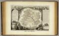
Dept. De La Marne.
1 : 561000 Levasseur, Victor.

Département de la Marne
1 : 260000 Marne (Francie : departement) Houdan, d' P. G. Chanlaire et Dumez
Département de la Marne
1 Karte : Kupferdruck ; 41 x 36 cm Capitaine s.n.
Sheet 5, uit: Stanford's large scale map of the seat of war / Stanford's Geographical Estab[lishmen]t
1 : 300000 Stanford's Geographical Establishment, Londen London : Stanford
Generalkarte von Zentraleuropa
Catalauni : evesché de Chalons sur Marne, et en Champagne
1 : 211000
La generalité de Paris, 2
1 Blatt : 67 x 52 cm chez l'auteur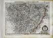
Champagne
1 Karte : Kupferdruck ; 17 x 24 cm Mercator Cloppenburgh
Champagne
1 : 505000 Champagne-oblast (Francie) apud Ioanem Ianßonium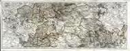
Carte du gouvernement de Champagne, 2
2 Blätter : 38 x 95 cm Bourgoin
Partie septentrionale du gouvernem. general de Champagne
1 Karte : Kupferdruck ; 47 x 58 cm Robert de Vaugondy; Haussard s.n.
Chalons - sur - Marne 124, uit: Special-Karte von Mittel-Europa / nach amtlichen Quellen bearbeitet von W. Liebenow
1 : 300000 titelvariant: W. Liebenow's Mittel-Europa; Annotatie: Titel boven de bladen: W. Liebenow's Mittel-Europa Johannes Wilhelm Liebenow 1822-1897 Frankfurt a. M. : Ludwig Ravenstein
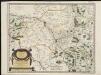
DIOECESE | de | RHEIMS, | et le païs de | RETHEL, | Par Iean Iubrien | Chalonnois.
Amsterdami, Apud Guilj. et Ioan. Blaeuw
Carte du gouvernement général de l'Isle de France, 2
1 Blatt : 79 x 55 cm Esnauts et Rapilly

Carte des dérivations d'eaux de sources
1 : 320000 [s.n.]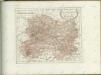

Dioecese de Rheims, et le païs de Rethel. [Karte], in: Novus Atlas, das ist, Weltbeschreibung, Bd. 2, S. 60.
1 Karte aus Atlas Blaeu, Joan Blaeu, Willem Janszoon