Maps of Hesse

Charte von Kur-Hessen / gezeichnet und hrsg. von C. Fembo ; berichtigt von I.L. Kellermann
1 : 300000 Annotatie: Met administratieve indeling Fembo, C.; Kellermann, I. L. Nürnberg : [Fembo]
Neueste Karte vom Kurfürstenthum Hessen
Grosser Hand-Atlas über alle Theile der Erde in 170 Karten Meyer, J. Verlag des Bibliographischen Instituts
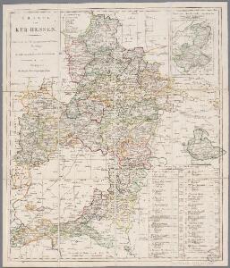
Charte von Kur-Hessen
1 : 360000 gezeichnet und hrsg. von C. Fembo berichtigt von I.L. Kellermann Nürnberg : [Fembo]
Churfurstenthum Hessen.
1 : 497000 Flemming, Carl

Des Ober-Rheinischen Creißes in Teutschland Nordlicher Theil mit Seinen abgetheilten Provintzen
1 : 1800000 Mollova mapová sbírka Weigel, Christoph Weigel, Christoph I.
Hassia landgraviatus
1 : 360000 Hesensko (Německo) Hondius, Henricus sumptibus Henrici Hondii
Parte Inferiore Del Circolo Dell' Alto Reno

Hassia landgraviatus
1 : 360000 Hesensko (Německo) Blaeu, Willem Janszoon Blaeu, Joan apud Guiljelmum et Johannem Blaeu
S. R. I. Circulus Rhenani Superior

Hessen, Schaumburg, Cassel.
1 : 625000 Grassl, J. (Joseph)
Hassia Lantgraviatus Tam Superior Casselanensis quam Inferior Darmstadina
1 : 410000 Mollova mapová sbírka Valk, Gerhard

Hassiae descriptio
1 Karte : Kupferdruck ; 32 x 23 cm Dryander; Ortelius s.n.
S. R. I. Circulus Rhenanus Superior in quo sunt landgraviatus Hasso-Casselensis Darmstadiensis et Rhenofeldensis abbatia Fuldensis principatus Waldeck et Hirschfeld Comitatus Nassau-Weilburg Usingen Wisbaden, et Idstein Solmensis Hanoviensis Isenburgensis superior Witgenstein Hatzfeld Westerburg et Hachenburg urbes imperiales: Franckfurt, Fridberg, Wetzlar et Gelenhausen
1 : 460000 Norimbergae : ex conatibus Joh. Baptistae Homanni
Hessen-Nassau
1 : 850000 Hesensko (Německo) Meyer, Joseph Bibliographisches Institut
S. R. I. Pars Septentrionalior Superioris Circuli Rhenani

Le landgraviat de Hesse-Cassel meridional et septentr. avec une partie du landgraviat de Hesse-Darmstadt et de la Vetteravie avec autres dependences
1 : 137000 Hesensko (Německo) Carlet, Louis-François Lotter, Tobias Conrad T. C. Lotter
Hassia landtgrauiatus
1 : 410000 Mollova mapová sbírka Mercator, Gerhard Hondius, Henricus
Mappa circuli Rhenani superioris
1 : 472000 Hesensko (Německo) Lotter, Tobias Conrad Tob. Conr. Lotter
Mappa circuli Rhenani superioris
1 : 472000 Hesensko (Německo) Lotter, Tobias Conrad Tob. Conr. Lotter
MAPPA CIRCULI RHENANI SUPERIORIS
1 : 470000 Durynsko (Německo) Lotter, Tobias Conrad Tob. Conr. Lotter
Mappa circuli Rhenani superioris
1 : 472000 Hesensko (Německo) Lotter, Tobias Conrad Tob. Conr. Lotter
Hassia Lantgraviatus Tam Superior Casselanensis quam Inferior Darmstadina
1 : 410000 Valk, Gerhard
Hassia landtgraviatus. [Karte], in: Gerardi Mercatoris Atlas, sive, Cosmographicae meditationes de fabrica mundi et fabricati figura, S. 376.
1 Karte aus Atlas Mercator, Gerhard Montanus, Petrus
Hassia landtgrauiatus
1 Karte : Kupferdruck ; 33 x 40 cm Mercator; Hondius sumptibus Henrici Hondij
Hassia landtgrauiatus
1 Karte : Kupferdruck ; 33 x 40 cm Mercator s.n.
S. R. I. circulus Rhenanus superior
1 : 256000 Durynsko (Německo) Homann, Johann Baptist J. B. Homann
S. R. I. circulus Rhenanus superior
1 : 485000 Durynsko (Německo) Homann, Johann Baptist J.B. Homann
S. R. I. circulus Rhenanus superior
1 : 256000 Durynsko (Německo) Homann, Johann Baptist J. B. Homann