Maps of Aceh Utara

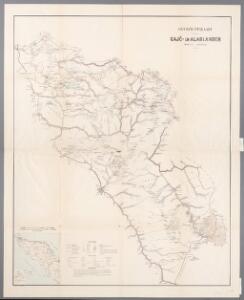
Overzichtskaart van de Gaj ̄o- en Alaslanden, uit: Overzichtskaart van de Gajō- en Alaslanden
1 : 200000 titelvariant: Kaart behoorende bij Het Gajōland en zijne bewoners; Annotatie: Bijkaart: Kaart aangevende de ligging der Gajō- en Alaslanden ten opzichte van de overige landschappen van Noord Sumatra (schaal 1:2.000.000); Omslagtitel: Kaart behoorende bij Het Gajōland en zijne bewoners, door C. Snouck Hurgronje; Annotatie geografische gegevens: Legenda Christiaan Snouck Hurgronje 1857-1936; Topographisch Bureau, Batavia Batavia : Topographisch Bureau
Overzichtskaart van de Gaj¯o- en Alaslanden
Topographisch Bureau Batavia Batavia : Topographisch Bureau
Tapaktoean / published by War Office = uitgegeven door War Office ; revised and photolithographed by War Office
War Office Washington D.C. [Washington D.C.] : War Office
Idi / published by War Office = uitgegeven door War Office ; revised and photolithographed by War Office
War Office Washington D.C. [Washington D.C.] : War Office
Blangkedjeren / samengesteld door den Topografischen Dienst (Kartogr[afische] Afd[eling] naar diverse gegevens in 1940
Topografische Dienst Batavia Batavia : Reproductiebedrijf Topografische Dienst
Lamië / samengesteld door den Topografischen Dienst (Kartogr[afische] Afd[eling] naar diverse gegevens in 1941
Topografische Dienst Batavia Batavia : Reproductiebedrijf Topografische Dienst
Meulaboh / published by War Office = uitgegeven door War Office ; revised and photolithographed by War Office
War Office Washington D.C. [Washington D.C.] : War Office
Loekoep / Topografische Inrichting
Topografische Inrichting Batavia Batavia : Topografische Inrichting
Takingeun : opgenomen door den Topografischen Dienst in 1917-1926
Topografische Dienst Weltevreden (Batavia) Weltevreden (Batavia) : Reproductiebedrijf Topografische Dienst
Laoet Tawar : opgenomen door den Topografischen Dienst in 1916-1920
Topografische Inrichting Batavia Batavia : Topografische Inrichting
[G[oenoeng] Poenti] / photolithographed and printed by 65 Rep. group I.E.
Survey Directorate H.Q. ALFSEA [S.l.] : Sur[ve]y Directorate H.Q. ALFSEA
Boven Besitang : opgenomen door den Topografischen Dienst in 1933-1934
Topografische Dienst Batavia Batavia : Reproductiebedrijf Topografische Dienst
Koetatjane : opgenomen door den Topografischen Dienst in 1933-1934
Topografische Dienst Batavia Batavia : Reproductiebedrijf Topografische Dienst
[Laoet Tawar] / photolithographed and printed by 65 Rep. group I.E.
Survey Directorate H.Q. ALFSEA [S.l.] : Sur[ve]y Directorate H.Q. ALFSEA
[Ramasan] / photolithographed and printed by 65 Rep. group I.E.
Survey Directorate H.Q. ALFSEA [S.l.] : Sur[ve]y Directorate H.Q. ALFSEA
[G[oenoeng] Mesir] / photolithographed and printed by 65 Rep. group I.E.
Survey Directorate H.Q. ALFSEA [S.l.] : Sur[ve]y Directorate H.Q. ALFSEA
[Blang Oebor-Oebor / photolithographed and printed by 65 Rep. group I.E.
Survey Directorate H.Q. ALFSEA [S.l.] : Sur[ve]y Directorate H.Q. ALFSEA
[Teungkoe Digoedam] / Topographische Inrichting
Topografische Dienst Batavia Batavia : Topographische Inrichting
[Glanggang Merak] / Topographische Inrichting
Topografische Dienst Batavia Batavia : Topographische Inrichting
[Langsar] / Topographische Inrichting
Topografische Inrichting Batavia Batavia : Topographische Inrichting
[Koeala Simpang] / Topographische Inrichting
Topografische Inrichting Batavia Batavia : Topographische Inrichting
Midden Peutoë : opgenomen door den Topografischen Dienst in 1935-1936
Topografische Dienst Batavia Batavia : Reproductiebedrijf Topografische Dienst
[Ladanggoesta] : opgenomen door den Topografischen Dienst in 1917-1918 en 1920-1923
Topografische Inrichting Batavia Batavia : Topografische Inrichting
[Laubaleng] : opgenomen door den Topografischen Dienst in de jaren 1919-1923
Topografische Inrichting Batavia Batavia : Topografische Inrichting
Peudawa-Rajeu : opgenomen door den Topografischen Dienst in 1938
Topografische Dienst Batavia Batavia : Reproductiebedrijf Topografische Dienst
Pajabakong : opgenomen door den Topografischen Dienst in 1935-1936
Topografische Dienst Batavia Batavia : Reproductiebedrijf Topografische Dienst
Goenoeng Besar : opgenomen door den Topografischen Dienst in 1935-1936
Topografische Dienst Batavia Batavia : Reproductiebedrijf Topografische Dienst
Mbang : opgenomen door den Topografischen Dienst in 1936-1937
Topografische Dienst Batavia Batavia : Reproductiebedrijf Topografische Dienst
Iemirah : opgenomen door den Topografischen Dienst in 1936-1937
Topografische Dienst Batavia Batavia : Reproductiebedrijf Topografische Dienst