Maps of Carpathian Mountains

[Kaart], uit: Übersichtskarte der gewerblichen Unterrichts-Anstalten in Österreich / entw. u. gezeichnet von Karl Peucker ; bearb. von Adolf Müller
1 : 1700000 titelvariant: Die gewerblichen Unterrichts-Anstalten in Österreich; Annotatie: Omslagtitel: Die gewerblichen Unterrichts-Anstalten in Österreich; Opdrachtgever: K.K. Ministerium für Cultus und Unterricht; Met lijst van instellingen voor beroepsonderwijs Peucker, Karl; Müller, Adolf (fl. 1899) Wien : Artaria
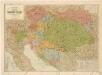
Císařství Rakouské
1 : 729000 Rakousko-Uhersko c. k. školní knihosklad
Bez titulu: Östereich

Bez titulu: Östereich

Bez titulu: Östereich

[Historisch-geographischer Atlas zu den allgemeinen Geschichtswerken von C. v. Rotteck, Pölitz u. Becker] : Oestreich zur Uebersicht der Hauptbegebenheiten dieses Staates
von Julius Loewenberg Lithographie von B. Herder in Freiburg im Breisgau [Freiburg im Breisgau] : [Herder]
Der Oesterreichische Kaiser-Staat
Hand-Atlas über alle Theile der Erde nach dem neuesten Zustande und über das Weltgebäude Stieler, Adolf bei Justus Perthes
Routenkarte der eisenbahnen von Österreich, Ungarn und Bosnien-Herzegowina
Eberle, Joseph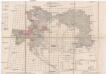
Übersichts-Blatt zur Spezial-Karte der österr[eichisch] ung[arischen] Monarchie
Evropa střední K. u. k. Militärgeographisches Institut
Strassen- und Eisenbahnkarte des oesterreichischen Kaiserthumes
1 : 864000 Rakousko (1804-1867) Schaller, Georg k.k. militärisch-geographisches Institut
Austrian Empire.
1 : 4100000 Tanner, Henry S.
Austrian Empire.
1 : 3380000 Sharpe, J.
Schulkarte von Österreich-Ungarn
Šolcova nejnovější politická a železniční cestovní mapa Rakousko – Uherska

Austria.
1 : 4000000 Colton, G.W.
Der Oesterreichische Kaiserstaat
1 : 3700000 Evropa jihovýchodní Weiland, Karl Ferdinand im Verlage des Geograph. Instituts
Der Oesterreichische Kaiserstaat
1 : 3700000 Evropa jihovýchodní Weiland, Karl Ferdinand Metzeroth, C. im Verlage des Geograph. Instituts
Uibersichtskarte von Oesterreich in Hinsicht auf Raum- und Bevölkerungs-Verhältnisze der einzelnen Länder dieses Kaiserthumes
Rakousko Schnabel, Jiří Norbert Schönflug, Jakub
Landwehrterritorial- und Landwehr-Ergänzungsbezirkseinteilung
1 : 3000000 Rakousko-Uhersko k.u.k. Militärgeographisches Institut
Militärterritorial und Ergänzungsbezirkseinteilung
1 : 3000000 Rakousko-Uhersko k.u.k. Militärgeographisches Institut
Landwehrterritorial- und Landwehr-Ergänzungsbezirkseinteilung
1 : 3000000 Rakousko-Uhersko k.u.k. Militärgeographisches Institut
Austria.
1 : 4000000 Colton, G.W.
Ethnographical map of Austria-Hungary. 1918
1 : 4000000 First World War ethnographical map of Austria-Hungary. 1918. War Office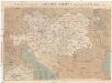
Prochaska's Eisenbahnkarte von Oesterreich-Ungarn für 1894
1 : 1500000 Evropa jihovýchodní Karl Prochaska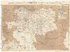
Prochaska's Eisenbahnkarte von Oesterreich-Ungarn für 1892
1 : 1500000 Evropa jihovýchodní Karl Prochaska
Oesterreich-Ungarn Eisenbahn-Karte
1 : 1500000 Budapešť (Maďarsko) Bomsdorff, Theodor von Karl Prochaska
Oesterreich-Ungarn Eisenbahn-Karte
1 : 1500000 Budapešť (Maďarsko) Bomsdorff, Theodor von Karl Prochaska
Oesterreich-Ungarn Eisenbahn-Karte
1 : 1500000 Rakousko-Uhersko Bomsdorff, Theodor von Karl Prochaska
Oesterreich-Ungarn Eisenbahn-Karte
1 : 1500000 Rakousko-Uhersko Bomsdorff, Theodor von Karl Prochaska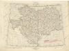
![[Kaart], uit: Übersichtskarte der gewerblichen Unterrichts-Anstalten in Österreich / entw. u. gezeichnet von Karl Peucker ; bearb. von Adolf Müller](https://images-2.georeferencer.com/images/iiif/684320905671/full/,300/0/native.jpg)

