Maps of Friuli-Venezia Giulia

Abriss der neuen Stadt und Festung Palmae = Nova Palmae civitas
1 : 8000 titelvariant: Nova Palmae civitas; Annotatie: Met 6 regels tekst (Latijn en Duits) [S.l. : s.n.]
Strassoldo.
from Spezialkarte der osterreichisch-ungarischen Monarchie.
Gorz und Gradisca.
from Spezialkarte der osterreichisch-ungarischen Monarchie.
[Gorice a Gradiška]
Gorice a Gradiška im Verl. des Geograph. Instituts
Ducatus Carnioliae Tabula Chorographica Iusu Sumptuque inclytorum Provinciae Statuum.
1 : 100000 Mollova mapová sbírka Florjančič de Grienfeld, Janez Dizma
Comitatus Goritiae Et Finitima
1 : 115000 Mollova mapová sbírka Coronini, Rudolf Winkler, Johann Christoph
Mappa Generalis in Qua Danubii Fl. Caetium Montem inter et Bulgariae Flumen Jantram, Intercepti Tractus Integer In Subsequentibus XVIII. Secrionibus Divisim Specialissimè Exhibendus Repraesentatur. Notandum Sectionibus illis Lineolas per Transversum Secantes Danubium Iisque Interpositos Numeros Respondere
1 : 100000 Mollova mapová sbírka Marsili, Luigi Ferdinando
Trst
1 : 200000 Terst (Itálie) Kartografska radionica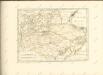

Der Goerzer Kreis und der Triester Kreis
1 : 260000 Gorizia (Itálie) Kindermann, Joseph Karl Junker, Christoph Franz Xaver Miller
Comitatus Goritiae et Gradiscae
1 : 216000 Mollova mapová sbírka Coronini, Rudolf
Gründt Riß der Statt Görtz
Mollova mapová sbírka Merian, Matthaeus Merian, Caspar
Comitatus Goritiae et Gradiscae cum limitibus Venetis et vicinia
1 : 220000 Benátky (Itálie) Coronini, Rudolf Quischae, D.

Istria olim Iapidia [Karte], in: Le théâtre du monde, ou, Nouvel atlas contenant les chartes et descriptions de tous les païs de la terre, Bd. 3, S. 155.
1 Karte aus Atlas Blaeu, Willem Janszoon und Blaeu, Joan Blaeu, Willem Janszoon
Carta d ́Italia speciale per Automobilisti

Le Frioul
1 : 278000 Furlandsko Santini, P. Remondini, M. M. Remondini
Carta topografica della provincia del Friuli
1 : 162000 Furlandsko Malvolti, Giuseppe Zuliani, Pietro
Aus der Übersichtskarte von Mittel-Europa 1:750 000
1 : 750000 Evropa střední K. k. Österreichische Staatsbahnen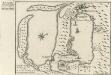
Buccari samt dessen Seehafen und derer tieffen in Istrien am Adriatischen Meer gelegen dem Kayser gehörig
Mollova mapová sbírka Bodenehr, Gabriel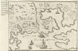
Accurater Plan des Kayserliche freyen See-Hafen Fiume oder S. Veit am Flaun, an den Grentzen des Hertzogthus Crain und des Oesterreichischen Istrien am Golfo di Carnero, und am Einfluss des Flusses Fiume
Mollova mapová sbírka Bodenehr, Gabriel
Carta del Friuli tra i fiumi Livenza ed Isonzo
1 : 200000 Furlandsko Marinelli, Giovanni Taramelli, Torquato E. Passero
Il Friuli colla Carnia e Cadorino di nuova projezione
1 : 402000 Furlandsko Pitteri, Marco Alvise Antonio Zatta
Carta delle contee di Gorizia, di Gradisca, distetto di Trieste, e del Friuli Veneto
1 : 208000 Burgenland (Rakousko) Capellaris, Giann Antonio Tommasini
Patria del | FRIVLI | olim | FORVM IVLII.
[Amsterdam : Joan Blaeu]

Patria del Friuli olim Forum Iulii [Karte], in: Novus Atlas, das ist, Weltbeschreibung, Bd. 3, S. 148.
1 Karte aus Atlas Blaeu, Joan Blaeu, Willem Janszoon
Carta Generale del Regno Lombardo-Veneto e paesi limitrofi... II.

Patria del Friuli olim Forum Iulii [Karte], in: Theatrum orbis terrarum, sive, Atlas novus, Bd. 3, S. 128.
1 Karte aus Atlas Blaeu, Joan Blaeu, Willem Janszoon


