Maps of Orange County
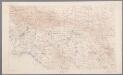
[Recto], uit: [Los Angeles-Riverside area] / R.U. Goode, geographer in charge ; comp. by J.E. Rockhold
1 : 250000 Annotatie geografische gegevens: Opname: 1893-1900 Goode, R. U.; Rockhold, J. E. [Washington, D.C. : U.S. Geological Survey]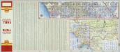
Los Angeles and Vicinity (continued from previous image).
Shell Oil Company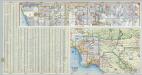
Los Angeles and Vicinity.
Shell Oil Company
Existing airports & landing fields, County of Los Angeles
1 : 1250000 Includes inset of north part of Los Angeles County and index. Los Angeles County (Calif.). Regional Planning Commission [Los Angeles, Calif.] The Commission
California Freeway and Expressway System, January 1967.
1 : 1192107 California Department of Transportation, Division of Highways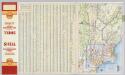
Los Angeles and Vicinity.
1 : 285120 Shell Oil Company
Commutation time (at 15 minute intervals) and distribution of population, Los Angeles County, 1930.
1 : 1200000 Commuting California Los Angeles County. Hand colored. "Source: Regional Planning Commission, Los Angeles." United States. Federal Housing Administration. Division of Economics & Statistics. [Washington, D.C.?] Federal Housing Administration, Division of Economics and Statistics
Verso: Los Angeles, California.
Hill, E. F.
Location map, Los Angeles County airports, showing motion picture studios
1 : 1220000 Relief shown by hachures and spot heights. Includes text. Regional Planning Commission, County of Los Angeles, California [Los Angeles, Calif.] The Commission.
Map Showing State Highway System (California), 1932.
1 : 1463040 California Department of Public Works, Division of Highways
Map of Beaches and Nearby Point of Interest, City of Los Angeles.
Security Savings Bank
Southern portion of Los Angeles County showing historical trails and landmarks
1 : 1275000 Mapped by D.C. Newmarch. Federal Writers' Project. Kirkman, George W. [California? : s.n.]
Population distribution in the Los Angeles area as of 1910
Map prepared by the Engineering Department, Automobile Club of Southern California.| Automobile Club of Southern California. Engineering Dept. The Department
Population distribution in the Los Angeles area as of 1920
Map prepared by the Engineering Department, Automobile Club of Southern California. Automobile Club of Southern California. Engineering Dept. The Department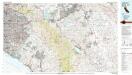
Santa Ana
1 : 100000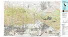
San Bernardino
1 : 100000
Pictorial map of the Los Angeles metropolitan district: a complete geographical guide to the fastest growing territory in the entire world / drawn for the Los Angeles times by Charles H. Owens.
"Showing in accurate detail and in relief the location of cities, towns, highways, railroads, water courses, coast developments, parks, airports, government stations, oil fields, natural landmarks, etc." Includes index. Owens, Charles H. Los Angeles, Calif.] : Los Angeles times
San Jacinto quadrangle showing San Andreas Rift, Mission Creek Fault.
1 : 125000 U.S. Geological Survey
San Jacinto
1 : 125000
San Jacinto
1 : 125000
San Jacinto
1 : 125000
San Jacinto
1 : 125000
San Jacinto
1 : 125000
San Jacinto
1 : 125000
San Jacinto
1 : 125000
San Jacinto
1 : 125000
San Jacinto
1 : 125000
Corona
1 : 125000
Corona
1 : 125000
Corona
1 : 125000
Corona
1 : 125000
Corona
1 : 125000
Corona
1 : 125000
Corona
1 : 125000
Elsinore
1 : 125000
Elsinore
1 : 125000
Elsinore
1 : 125000
Elsinore
1 : 125000
Elsinore
1 : 125000
Elsinore
1 : 125000
Elsinore
1 : 125000
![[Recto], uit: [Los Angeles-Riverside area] / R.U. Goode, geographer in charge ; comp. by J.E. Rockhold](https://images-2.georeferencer.com/images/iiif/484938444242/full/,300/0/native.jpg)

