Maps of Zürich

Offizieller Uebersichtsplan der Stadt Zürich
1 : 7500 Topogr. Anstalt Winterthur: J. Schlumpf, vormals Wurster, Randegger & Cie.
Übersichtsplan von Zürich und Umgebung
1 : 5000 Vögeli, Arnold (geb. 1826)
Offizieller Uebersichtsplan der Stadt Zürich
1 : 7500 1 Karte hrsg. Vermessungsamt der Stadt Zürich
Plan der Stadt Zürich mit Umgebung
1 : 10000 1 Plan nach den neuesten Aufnahmen zusammen getragen von H. Weiss-Keiser
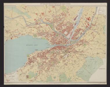
Offizieller Uebersichtsplan der Stadt Zürich
1 : 7500 1 Plan hrsg. Vermessungsamt der Stadt Zürich
Uebersichtsplan der Stadt Zürich nebst Umgebung
1 : 6600 Orell Füssli & Co.
Strassen-Übersichtsplan von Zürich und Umgebung
1 : 8800 1 Plan gez. von H. Keller
Strassen-Übersichtsplan von Zürich und Umgebung
1 : 8800 1 Plan gez. von Hch. Keller
Plan der Stadt Zürich u. Umgebung nach dem grossen offiziellen Plane
1 : 10000 1 Plan
Strassen-Uebersichtsplan von Zürich und Umgebung
1 : 8800 1 Plan gezeichnet von Hch. Keller
Strassen-Uebersichtsplan von Zürich und Umgebung
1 : 8800 1 Plan Gezeichnet von Hch. Keller
[Recto], uit: [Zürich]
1 : 12500 Annotatie: Bijlage bij: Führer durch Zürich u. Umgebung / hrsg vom Offiziellen Verkehrsbureau; Annotatie geografische gegevens: West boven Zürich : Kartogr. Anstalt Hofer & Co.
[Zürich]
1 : 20000 1 Plan
Uebersichtsplan von Zürich
1 : 10000 1 Plan
[Zürich]
1 : 12000 Orell Füssli
[Zürich]
1 : 10000 1 Plan
Plan von Zürich & Umgebung
1 : 16000 1 Plan
Übersichtsplan der Stadt Zürich nebst Umgebung, bearbeitet für das Adressbuch der Stadt Zürich
Orell Füssli und Cie., in Zürich
[Zürich]
1 : 10000 1 Plan
Plan der stadt Zürich
1 : 12000 Curych (Švýcarsko : oblast) Orell Füssli
Bericht betreffend Zürcher Strassenbahnen
1 : 10000 Darstellung der Strassenzüge Brüstlein, John E. ; Riggenbach, E. Lithographie, Druck und Verlag Hofer & Burger
[Zürich]
1 : 12500 Zurich (Switzerland). Vermessungsamt Kartogr. Anstalt Hofer & Co.
Plan von Zürich und Umgebung
1 : 10000 1 Plan
Streckenmesser für das Droschkenwesen von Zürich & Ausgemeinden
1 : 10000 1 Plan
Projekierte Einmündung der rechtsseitigen Seebahn in den Nordost-Bahnhof in Zürich; Übersichtsplan
1 : 10000 Ohne Datumsangabe. Wurster, Randegger und Cie., in Winterthur
Plan von Zürich & Umgebung
1 : 10000 1 Plan
[Zürich]
1 : 10000 1 Plan
Plan von Zürich & Umgebung
1 : 18000 1 Plan
Plan der Stadt Zürich
1 : 10000 Mit roter Einzeichnung von Bahn- und Quaiprojekten. Ohne Datumsangabe. Wurster, Randegger und Cie., in Winterthur